Old Maps of Queens, New York for Metal Detecting
Plan your next treasure hunt with 74 historic maps of Queens. Find old homesites, ghost towns, trails, and gathering spots that may be lost to time — perfect for identifying promising metal detecting locations.
- Locate forgotten sites: Uncover places like long-lost settlements, abandoned rail lines, or gathering spots.
- Plan better hunts: Use map overlays combined with LiDAR or satellite views to narrow in on historically rich areas.
- Made for detectorists: Thousands of hobbyists use these maps to discover relics, coins, and hidden history.
Use these historic maps to boost your research and find new opportunities beneath the surface of Queens.
Queens, New York maps
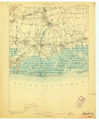
(74)- 1889 Map of Brooklyn
 1889 Brooklyn1889 Print · USGSCovers Queens, including New York, Hempstead, and other nearby areas
 - 1891 Map of Brooklyn
 1891 Brooklyn1891 Print · USGSCovers Queens, including New York, Hempstead, and other nearby areas
 - 1891 Map of Harlem
 1891 Harlem1891 Print · USGSCovers Queens, including New York, North Hempstead, and other nearby areas
 - 1897 Map of Harlem, 1956 Print
 1897 Harlem1956 Print · USGSCovers Queens, including New York, North Hempstead, and other nearby areas4 unique versions available
 - 1897 Map of Brooklyn, 1959 Print
 1897 Brooklyn1959 Print · USGSCovers Queens, including New York, Hempstead, and other nearby areas3 unique versions available
 - 1897 Map of Hempstead, 1961 Print
 1897 Hempstead1961 Print · USGSCovers Queens, including New York, Hempstead, and other nearby areas
 - 1897 Map of Oyster Bay, 1963 Print
 1897 Oyster Bay1963 Print · USGSCovers Queens, including New York, Hempstead, and other nearby areas
 - 1898 Map of Harlem
 1898 Harlem1898 Print · USGSCovers Queens, including New York, North Hempstead, and other nearby areas
 - 1898 Map of Hempstead
 1898 Hempstead1898 Print · USGSCovers Queens, including New York, Hempstead, and other nearby areas
 - 1898 Map of Staten Island
 1898 Staten Island1898 Print · USGSCovers Queens, including New York, Newark, and other nearby areas
 - 1898 Map of Brooklyn
 1898 Brooklyn1898 Print · USGSCovers Queens, including New York, Hempstead, and other nearby areas
 - 1898 Map of Oyster Bay
 1898 Oyster Bay1898 Print · USGSCovers Queens, including New York, Hempstead, and other nearby areas
 - 1899 Map of Hempstead
 1899 Hempstead1899 Print · USGSCovers Queens, including New York, Hempstead, and other nearby areas
 - 1900 Map of Passaic
 1900 Passaic1900 Print · USGSCovers Queens, including New York, Newark, and other nearby areas
 - 1900 Map of Staten Island
 1900 Staten Island1900 Print · USGSCovers Queens, including New York, Newark, and other nearby areas10 unique versions available
 - 1900 Map of Harlem
 1900 Harlem1900 Print · USGSCovers Queens, including New York, North Hempstead, and other nearby areas16 unique versions available
 - 1900 Map of Brooklyn
 1900 Brooklyn1900 Print · USGSCovers Queens, including New York, Hempstead, and other nearby areas11 unique versions available
 - 1900 Map of Oyster Bay
 1900 Oyster Bay1900 Print · USGSCovers Queens, including New York, Hempstead, and other nearby areas15 unique versions available
 - 1903 Map of Hempstead
 1903 Hempstead1903 Print · USGSCovers Queens, including New York, Hempstead, and other nearby areas9 unique versions available
 - 1905 Map of Passaic
 1905 Passaic1905 Print · USGSCovers Queens, including New York, Newark, and other nearby areas4 unique versions available
 - 1942 Map of Passaic
 1942 Passaic1942 Print · USGSCovers Queens, including New York, Newark, and other nearby areas
 - 1944 Map of Newark, 1971 Print
 1944 Newark1971 Print · USGSCovers Queens, including New York, Philadelphia, and other nearby areas5 unique versions available
 - 1947 Map of Brooklyn
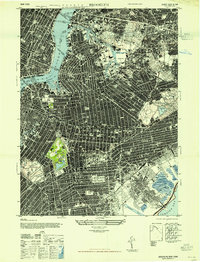 1947 Brooklyn1947 Print · USGSCovers Queens, including New York, Kings County, and other nearby areas
 - 1947 Map of Sea Cliff
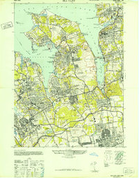 1947 Sea Cliff1947 Print · USGSCovers Queens, including New York, Oyster Bay, and other nearby areas
 - 1947 Map of Jamaica
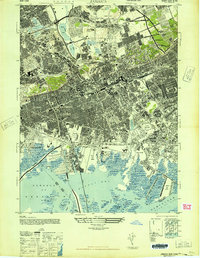 1947 Jamaica1947 Print · USGSCovers Queens, including New York, Hempstead, and other nearby areas
Showing maps 1-25 of 74
Frequently asked questions
- What are the different types of historical maps available for Queens?
- What is the oldest map of Queens?
- Where can I purchase historical maps of Queens for my home or office?
- Where can I download high-res historical maps of Queens?
- Are there historical topographic maps available for Queens?
- Is there historical aerial imagery available for Queens?
- Where are historical maps of Queens sourced from?