Old Maps of Hartland, New York
Explore 61 old maps of Hartland, spanning from 1897 to today. These high-resolution historic maps reveal how streets, neighborhoods, landmarks, and natural features evolved over time — perfect for genealogy, metal detecting, research, and local history exploration.
What you can do with these maps:
- See how Hartland changed over time: Compare historical maps to modern-day views to trace roads, homesites, rail lines & more.
- View detailed metadata: Each map includes creators, publishers, year, scale, and archive source.
- Overlay maps with satellite & LiDAR: Visualize the past alongside modern tools to explore terrain & human change.
- Trusted historical sources: Maps sourced from the USGS, Library of Congress, and other archives.
- Access maps your way: View online, download high-res files, or order prints for personal or research use.
Start exploring old maps of Hartland to uncover forgotten places, hidden landmarks, and the deep history beneath your feet.
Hartland, NY maps
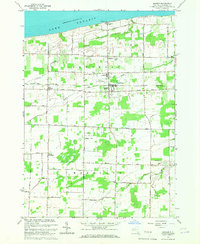
(61)- 1897 Map of Olcott
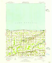
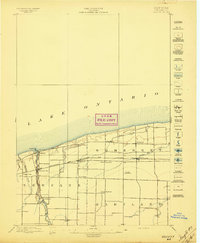 1897 Olcott1897 Print · USGSNiagara County's lakefront and agricultural interior are captured here in the late 1890s as the rail era reached its peak. Genealogists can trace family lands near Newfane or locate early infrastructure like the Olcott L.H. and the Rome Watertown and Ogdensburg R.R. line.6 unique versions available
 - 1897 Map of Medina
 1897 Medina1897 Print · USGSWestern New York at the close of the nineteenth century reveals a landscape defined by the Erie Canal and the Tonawanda Indian Reservation. Researchers can trace the early rail-and-water economy through settlements like Medina, Akron, and the vanished stops of Smithville Sta.7 unique versions available
 - 1897 Map of Lockport
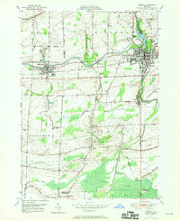
 1897 Lockport1897 Print · USGSNiagara County was a powerhouse of canal and rail commerce during the 1890s, centered on the engineering marvels at Lockport. Genealogists and historians can trace the early foundations of Clarence Center, locate Swifts Mills, or follow the original path of the Erie Canal past Raynales Basin.
 - 1897 Map of Ridgeway
 1897 Ridgeway1897 Print · USGSOrleans and Niagara Counties are captured here in the late 1890s, where the bustling ERIE CANAL and the Rome Watertown and Ogdensburg R. R. define the local economy. Genealogists and historians can trace family-named sites along the Ridge Road and locate long-standing hamlets like Lyndonville and Kuckville.5 unique versions available
 - 1899 Map of Niagara
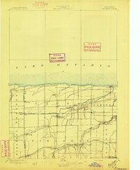
 1899 Niagara1899 Print · USGSThe Niagara Frontier is mapped here in the late nineteenth century as a bustling corridor of trade and transport. Researchers can trace the path of the Erie Canal through Lockport or locate early rural settlements like Ransomville and the Tuscarora Indian Reservation.6 unique versions available
 - 1902 Map of Lockport
 1902 Lockport1902 Print · USGSNiagara and Erie Counties thrived at the turn of the century as the Erie Canal and heavy rail transformed the region. Researchers can trace ancestral property near Lockport or locate vanished stops along the Batavia and Tonawanda Shore Line and near Reynales Basin.6 unique versions available
 - 1905 Map of Lockport, 1906 Print
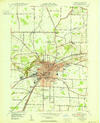
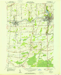
 1905 Lockport1906 Print · USGSNiagara and Erie counties at the height of the canal and rail era show a landscape defined by the Erie Canal. Trace family roots in Lockport or explore early transit networks through Transit Sta., Akron, and the Electric R. R.
 - 1948 Map of Lockport, 1953 Print
 1948 Lockport1953 Print · USGSNiagara and Erie Counties are shown here during the late forties, when the canal and rail lines still anchored the regional economy. Researchers can locate numerous numbered rural schoolhouses and vanished stops like Hodgeville Sta or Akron Junction.3 unique versions available
 - 1948 Map of Olcott, 1956 Print
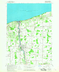
 1948 Olcott1956 Print · USGSNiagara County's lakefront and orchard country are captured here in the late 1940s as industry and agriculture moved by rail. Trace the New York Central line through Newfane or locate family roots at St Johns Ch, Corwin Cem, and various numbered schoolhouses.
 - 1949 Map of Barker
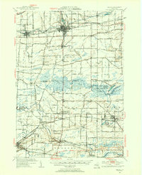
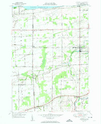
 1949 Barker1949 Print · USGSNiagara County's Lake Ontario shoreline in the late 1940s is defined by productive orchards and small rail-centered villages. Genealogists and historians can trace the foundations of local life through landmarks like Quaker Road Ch, the Trade School Airport, and School No 11.
 - 1949 Map of Medina, 1970 Print
 1949 Medina1970 Print · USGSThe Erie Canal and New York Central railroad define this late 1940s landscape between Middleport and Medina. Researchers can trace rural life through landmarks like School No 15, the Site of Neuter Fort, and Boxwood Cem.
 - 1950 Map of Newfane
 1950 Newfane1950 Print · USGSNiagara County's lakefront and agricultural heartland are captured here at mid-century as the region's rural character remained firmly intact. Researchers can trace family sites near Olcott and Newfane, locating specific landmarks like Sawyer Cem, School No 6, and the New York Central Railroad.
 - 1950 Map of Lockport
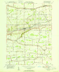
 1950 Lockport1950 Print · USGSLockport and its surrounding townships thrive along the Erie Canal in the post-war era. Genealogists and local historians can trace legacy sites like Cold Spring Cem, the Chapel of the Good Shepherd, and the International Railway corridor.
 - 1950 Map of Gasport
 1950 Gasport1950 Print · USGSNiagara County's canal and rail corridor is captured here at mid-century, following the Erie Canal through Gasport. Genealogists and local historians can trace the foundations of several hamlets including Reynales Basin, Terrys Corner, and Orangeport Settlement.
 - 1950 Map of Medina, 1956 Print
 1950 Medina1956 Print · USGSOrleans and Genesee Counties are mapped here in the mid-fifties, showing the industrial pulse of the Erie Canal and New York Central corridor. Genealogists can locate numerous rural schools and landmarks like the Site of Neuter Fort, Boxwood Cem, and the Tonawanda Indian Reservation.2 unique versions available
 - 1950 Map of Ridgeway, 1956 Print
 1950 Ridgeway1956 Print · USGSOrleans County, New York, is captured here at mid-century, where Lake Ontario orchards meet the busy corridor of the historic Erie Canal. Researchers can trace the legacy of rural education and community at School No. 16 or locate family plots at Otter Creek Cemetery and Fuller Cemetery.2 unique versions available
 - 1951 Map of Lyndonville
 1951 Lyndonville1951 Print · USGSOrleans and Niagara counties meet along this coastal stretch of Lake Ontario during the early fifties. Genealogists and local historians can trace the foundations of these communities through the locations of School No 10, St Patricks Cem, and the rail stops of the New York Central.2 unique versions available
 - 1951 Map of Medina
 1951 Medina1951 Print · USGSOrleans and Niagara Counties hum with activity in the mid-century as the Erie Canal and rail lines drive the local economy. Genealogists can locate several rural schoolhouses and family plots, such as Boxwood Cem and School No 16.
 - 1952 Map of Toronto, 1954 Print
 1952 Toronto1954 Print · USGSLake Ontario and the international border define this mid-century landscape of rapid industrial and suburban growth. Researchers can trace the vital shipping and rail corridors of the era, from the Welland Canal to the New York Central Railroad.
 - 1962 Map of Toronto, 1982 Print
 1962 Toronto1982 Print · USGSThe Golden Horseshoe and the Niagara Frontier meet in this early 1960s study of a growing international border region. Trace the path of the Welland Canal and locate land marks like the Scarborough Bluffs and Tuscarora Indian Reservation.
 - 1965 Map of Toronto
 1965 Toronto1965 Print · USGSThe Golden Horseshoe and Niagara Frontier are shown in detail during the early sixties, highlighting the international shipping and transit networks. Trace the path of the Erie Canal, the Welland Canal, and rail lines connecting Toronto and Niagara Falls.2 unique versions available
 - 1965 Map of Gasport, 1967 Print
 1965 Gasport1967 Print · USGSNiagara County's agricultural and canal-side life is captured here in the mid-sixties, from the banks of the Erie Canal to the hamlets of Hartland and Royalton Center. Genealogists and historians can locate family landmarks like the Orangeport Ch, Chestnut Ridge Cem, and the old Quarries.
 - 1965 Map of Barker, 1967 Print
 1965 Barker1967 Print · USGSThe Niagara County shoreline meets agricultural heartland in the mid-sixties, centered on the village of Barker and its rail connections. Genealogists and historians can locate the Quaker Cem, North Hartland, and the unusual Barker Central Sch Airport.
 - 1965 Map of Newfane, 1968 Print
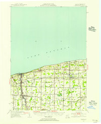
 1965 Newfane1968 Print · USGSNiagara County's Lake Ontario shoreline and the winding Eighteenmile Creek characterize this mid-century landscape. Genealogists and local historians can trace the foundations of Olcott and Newfane, locating landmarks like Corwin Cemetery and the New York Central rail line.
 - 1965 Map of Lockport, 1968 Print
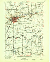
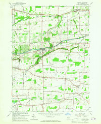
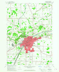 1965 Lockport1968 Print · USGSNiagara County's industrial and civic heart is captured here during the mid-sixties, centered on the historic Erie Canal. Researchers can trace old family names at Stahler Cem, locate the IOOF Home, or study the rail corridors of the Erie-Lackawanna.
Showing maps 1-25 of 61
Top cities near Hartland
- Amherst historical maps
- Clarence historical maps
- Lockport historical maps
- Lockport historical maps
- South Lockport historical maps
- Newfane historical maps
See more
Top neighborhoods of Hartland
Frequently asked questions
- What are the different types of historical maps available for Hartland?
- What is the oldest map of Hartland?
- Where can I purchase historical maps of Hartland for my home or office?
- Where can I download high-res historical maps of Hartland?
- Are there historical topographic maps available for Hartland?
- Is there historical aerial imagery available for Hartland?
- Where are historical maps of Hartland sourced from?