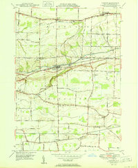
1950 Map of Gasport
USGS Topo · Published 1950About this map
The Erie Canal and the New York Central and Hudson River RR (Rochester Branch) run in parallel through this mid-century portrait of Niagara County, centering on the village of Gasport. This corridor serves as the primary artery for the region, where the industrial presence of the Middleport Water Supply and the transit hub at Reynales Basin meet a landscape largely defined by family orchards and small rural hamlets. The map meticulously documents the transition from the fruit-growing plains of Hartland in the north to the more varied elevation of Royalton in the south.
Find a feature on this map
39 named features on this map. Tap any name to fly to it.
Don’t see what you’re looking for? This feature index may not catch every label — zoom into the map to look around manually.
Map Details
Editions of this 1950 Gasport Map
This is the sole edition of this map. No revisions or reprints were ever made.
Other maps of this area

1897 · Olcott
USGS Topo · 1:62,500

1897 · Medina
USGS Topo · 1:62,500

1897 · Lockport
USGS Topo · 1:62,500

1897 · Ridgeway
USGS Topo · 1:62,500

1899 · Niagara
USGS Topo · 1:125,000

1902 · Lockport
USGS Topo · 1:62,500

1905 · Lockport
USGS Topo · 1:62,500

1948 · Lockport
USGS Topo · 1:62,500

1948 · Olcott
USGS Topo · 1:62,500
1949 · Barker
USGS Topo · 1:24,000