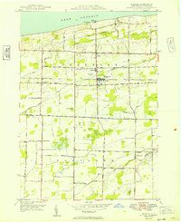
1949 Map of Barker
USGS Topo · Published 1949About this map
The village of Barker and the agricultural landscapes of Somerset and Hartland townships characterize this mid-century Lake Ontario shoreline. The New York Central RR cuts an east-west path through the center of the sheet, supporting local industry like the Cannery Waste Disposal near the village core. Educational and recreational infrastructure is well-represented, from the Trade School Airport and Central Sch to Camp Kenan on the lakefront. Local transit is defined by a rigid grid of rural corridors including Lake Road and Haight Road, connecting scattered hamlets such as West Somerset and North Hartland. Waterways like Fish Creek and Golden Hill Creek drain north toward the lake, while landmarks like the Quaker Road Ch and School No 11 serve as vital markers for family historians tracing the social fabric of Niagara County.
Find a feature on this map
36 named features on this map. Tap any name to fly to it.
Don’t see what you’re looking for? This feature index may not catch every label — zoom into the map to look around manually.
Map Details
Editions of this 1949 Barker Map
This is the sole edition of this map. No revisions or reprints were ever made.
Other maps of this area

1897 · Olcott
USGS Topo · 1:62,500

1897 · Medina
USGS Topo · 1:62,500

1897 · Lockport
USGS Topo · 1:62,500

1897 · Ridgeway
USGS Topo · 1:62,500

1899 · Niagara
USGS Topo · 1:125,000

1902 · Lockport
USGS Topo · 1:62,500

1905 · Lockport
USGS Topo · 1:62,500

1948 · Lockport
USGS Topo · 1:62,500

1948 · Olcott
USGS Topo · 1:62,500
1949 · Medina
USGS Topo · 1:24,000