1940s Maps of Augusta, New York
Explore 10 historic maps of Augusta from the 1940s. These maps offer a rare glimpse into what life looked like during the 1940s — showing old roads, neighborhoods, homes, and landmarks that have changed or disappeared over time.
Whether you're researching your family's past, planning a metal detecting trip, or studying how Augusta's landscape evolved across the 1940s, these high-resolution maps are a powerful tool for exploring the history of this region.
- Focus on a specific era: All maps on this page are from the 1940s, giving you a focused view of this time period.
- See what’s changed: Compare century-old streets, trails, and buildings to today's modern landscape using overlays and satellite layers.
- Research with precision: Use these maps for genealogy, historical research, land use analysis, or educational projects.
- View, download, or print: Maps are fully viewable online in high resolution, and can be downloaded or printed for your own records.
Start exploring Augusta's history through authentic maps from the 1940s. This is your window into the past.
Augusta, NY maps
(10)- 1943 Map of Sangerfield, 1960 Print
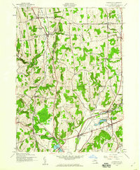
 1943 Sangerfield1960 Print · USGSCentral New York's dairy and rail heartland is meticulously documented here during the mid-forties. Genealogists and local historians can trace family-named crossroads and rural schoolhouses like Doolittle Sch, Brothertown, and Greens Crossing.
 - 1943 Map of Munnsville, 1960 Print
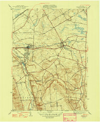
 1943 Munnsville1960 Print · USGSMadison County's valley floor and upland ridges are captured here during the 1940s, showing a landscape defined by old transit routes. You can trace the Chenango Canal and the New York Ontario and Western RR past Bouckville and Solsville.2 unique versions available
 - 1943 Map of Oriskany Falls, 1960 Print
 1943 Oriskany Falls1960 Print · USGSThe valleys of Oneida and Madison Counties were defined by a dual-railroad economy during the Second World War. Researchers can trace historic family lineages through sites like Thistle Cem, find rural schoolhouses like School No 10, or explore the village layouts of Waterville and Oriskany Falls.3 unique versions available
 - 1944 Map of Munnsville
 1944 Munnsville1944 Print · USGSMadison County during the mid-forties is depicted here as a landscape of established rail towns and hillside dairy farms. Genealogists can locate family landmarks like Cummings Cem and trace the paths of the New York Ontario and Western RR through Pratts Hollow and Bouckville.
 - 1944 Map of Oriskany Falls, 1957 Print
 1944 Oriskany Falls1957 Print · USGSOneida and Madison counties are shown here during the mid-1940s, where rural industry and rail lines intersected the high country. Researchers can locate family landmarks like St Bernards Cem, the settlement at Forge Hollow, and the expanse of Nine Mile Swamp.2 unique versions available
 - 1946 Map of Oneida, 1952 Print
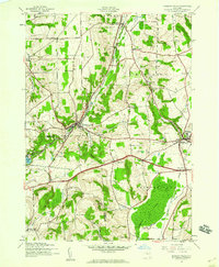
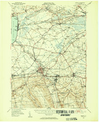 1946 Oneida1952 Print · USGSIn the mid-1940s, the corridor between Oneida Lake and the Erie Canal was a landscape of manufacturing towns and lakeside resorts. Genealogists and historians can trace the foundations of local communities through named landmarks like Oneida Castle, Irish Ridge Ch, and the Indian Sch.3 unique versions available
 - 1947 Map of Rome, 1952 Print
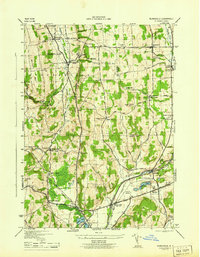
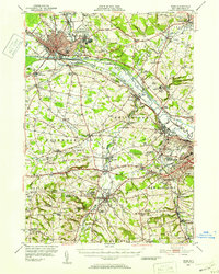 1947 Rome1952 Print · USGSMid-century Oneida County is captured here during the height of its industrial and military significance. Researchers can trace the paths of the Old Erie Canal, locate family roots near St Johns Cem, or study the grounds of Hamilton College.3 unique versions available
 - 1948 Map of Vernon
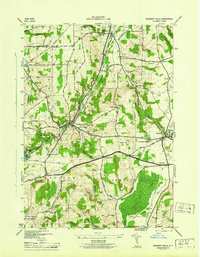
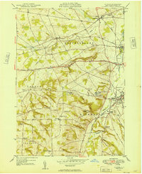
 1948 Vernon1948 Print · USGSThe communities of Oneida and Madison counties thrive along the Seneca Turnpike in the late 1940s. Genealogists can trace family lines through Valley View Cem or locate old schoolhouses like the Indian Sch and Willow Valley Sch.2 unique versions available
 - 1948 Map of Binghamton, 1980 Print
 1948 Binghamton1980 Print · USGSCentral New York and the Southern Tier thrive in the late 1940s as a hub of rail traffic and mountain industry. Researchers can trace historic transit lines like the Erie Railroad through Binghamton or find old valley settlements near Oneonta and Delhi.
 - 1949 Map of Clinton
 1949 Clinton1949 Print · USGSOneida County at mid-century reveals a landscape defined by the Oriskany Creek valley and the prominent campus of Hamilton College. Researchers can trace old family lines through Evergreen Cem or locate former mill sites near Farmers Mills and Franklin Springs.
End of results
Showing maps 1-10 of 10
Top cities near Augusta
- Utica historical maps
- Rome historical maps
- New Hartford historical maps
- Whitestown historical maps
- Oneida historical maps
- Kirkland historical maps
See more
Top neighborhoods of Augusta
Frequently asked questions
- What are the different types of historical maps available for Augusta?
- What is the oldest map of Augusta?
- Where can I purchase historical maps of Augusta for my home or office?
- Where can I download high-res historical maps of Augusta?
- Are there historical topographic maps available for Augusta?
- Is there historical aerial imagery available for Augusta?
- Where are historical maps of Augusta sourced from?