1940s Maps of Boonville, New York
Explore 7 historic maps of Boonville from the 1940s. These maps offer a rare glimpse into what life looked like during the 1940s — showing old roads, neighborhoods, homes, and landmarks that have changed or disappeared over time.
Whether you're researching your family's past, planning a metal detecting trip, or studying how Boonville's landscape evolved across the 1940s, these high-resolution maps are a powerful tool for exploring the history of this region.
- Focus on a specific era: All maps on this page are from the 1940s, giving you a focused view of this time period.
- See what’s changed: Compare century-old streets, trails, and buildings to today's modern landscape using overlays and satellite layers.
- Research with precision: Use these maps for genealogy, historical research, land use analysis, or educational projects.
- View, download, or print: Maps are fully viewable online in high resolution, and can be downloaded or printed for your own records.
Start exploring Boonville's history through authentic maps from the 1940s. This is your window into the past.
Boonville, NY maps
(7)- 1940 Map of Port Leyden
 1940 Port Leyden1940 Print · USGSUpper Lewis County at the start of the 1940s reveals a landscape shaped by the BLACK RIVER and the rail industry. Researchers can trace historic homesteads near Constableville, industrial sites at Goulds Mill, and the riverside Leyden Station PO.
 - 1945 Map of Boonville, 1954 Print
 1945 Boonville1954 Print · USGSOneida County at the close of the Second World War shows a landscape defined by the Black River and the rail lines. Genealogists and local historians can trace rural school districts like School No 5, the Hayes Cem, and the village layout of Boonville.
 - 1945 Map of Forestport, 1958 Print
 1945 Forestport1958 Print · USGSOneida County's Adirondack fringe comes into focus at the close of the war years, centered on the river-fed industry of the Black River valley. Genealogists and historians can trace rail-era landmarks like Forestport Station, Bardwell Mill, and Bethel Ch.4 unique versions available
 - 1946 Map of West Leyden
 1946 West Leyden1946 Print · USGSThe rural borderlands of Oneida and Lewis counties come into focus just after the war. Local historians can trace a lost network of rural education and community life through Alger Sch, West Leyden Cem, and the small settlement at Flint Town.
 - 1947 Map of West Leyden
 1947 West Leyden1947 Print · USGSThe rural borders of Lewis and Oneida counties come alive in the mid-1940s, centered on the village of West Leyden and the East Branch Mohawk River. Genealogists can trace family connections at Thornton Cem and explore vanished district schools like Evans Sch or Bates Sch.2 unique versions available
 - 1947 Map of Boonville
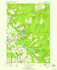
 1947 Boonville1947 Print · USGSOneida County in the mid-1940s shows a landscape defined by the winding Black River and the historic Black River Canal. Genealogists can locate several rural schoolhouses and family landmarks like Hayes Cem, North Steuben Ch, and Pixley Falls.
 - 1947 Map of Forestport
 1947 Forestport1947 Print · USGSOneida County in the late 1940s centers on the critical water routes of the Black River and the bustling rail corridor. Local historians can trace the foundations of Forestport, explore the grounds of Bardwell Mill, or locate family sites at Bethel Ch and Brooks Cem.2 unique versions available
End of results
Showing maps 1-7 of 7
Top cities near Boonville
- Rome historical maps
- Lee historical maps
- Trenton historical maps
- Floyd historical maps
- Lake Delta historical maps
- Russia historical maps
See more
Top neighborhoods of Boonville
- Alder Creek historical maps
- Hurlbutville historical maps
- Hawkinsville historical maps
- Boonville historical maps
Frequently asked questions
- What are the different types of historical maps available for Boonville?
- What is the oldest map of Boonville?
- Where can I purchase historical maps of Boonville for my home or office?
- Where can I download high-res historical maps of Boonville?
- Are there historical topographic maps available for Boonville?
- Is there historical aerial imagery available for Boonville?
- Where are historical maps of Boonville sourced from?