1940s Maps of Onondaga, New York
Explore 7 historic maps of Onondaga from the 1940s. These maps offer a rare glimpse into what life looked like during the 1940s — showing old roads, neighborhoods, homes, and landmarks that have changed or disappeared over time.
Whether you're researching your family's past, planning a metal detecting trip, or studying how Onondaga's landscape evolved across the 1940s, these high-resolution maps are a powerful tool for exploring the history of this region.
- Focus on a specific era: All maps on this page are from the 1940s, giving you a focused view of this time period.
- See what’s changed: Compare century-old streets, trails, and buildings to today's modern landscape using overlays and satellite layers.
- Research with precision: Use these maps for genealogy, historical research, land use analysis, or educational projects.
- View, download, or print: Maps are fully viewable online in high resolution, and can be downloaded or printed for your own records.
Start exploring Onondaga's history through authentic maps from the 1940s. This is your window into the past.
Onondaga, NY maps
(7)- 1943 Map of Syracuse East
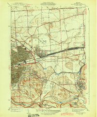 1943 Syracuse East1943 Print · USGSEastern Onondaga County during the mid-forties shows the industrial height of the rail and canal era. Genealogists and researchers can trace local landmarks like the Orphans Home, St Marys Cemetery, and the freight Yards at Minoa.2 unique versions available
 - 1943 Map of South Onondaga
 1943 South Onondaga1943 Print · USGSOnondaga County is captured during the mid-forties as Syracuse expands southward toward the ancestral lands of the Onondaga Indian Reservation. Genealogists and local historians can locate old district schools, numerous family cemeteries like Cedarvale Cem, and rural crossroads such as Lords Corners and Griffins Corners.
 - 1943 Map of Jamesville
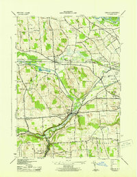
 1943 Jamesville1943 Print · USGSOnondaga County is captured during the mid-century as a network of hill-country villages and vital transit corridors. Researchers can trace ancestral locations through numerous family-named landmarks like Spoor Cem, the County Penitentiary, and several school districts including Central Sch.2 unique versions available
 - 1943 Map of Marcellus
 1943 Marcellus1943 Print · USGSOnondaga County's rural landscape is captured during the mid-forties, showing the village of Marcellus and the northern tip of Otisco Lake. Researchers can trace the legacy of local families through scattered schoolhouses like School No 16 and numerous burial grounds including Highland Cem and Fellows Cem.
 - 1943 Map of Camillus, 1951 Print
 1943 Camillus1951 Print · USGSOnondaga County in the early 1940s served as a bustling crossroads for the railroads and the historic Erie Canal. Genealogists can locate family burial plots at Fairmount Rural Cem and Oswego Bitter Cem or trace vanished rail stops like Amboy Station.3 unique versions available
 - 1947 Map of Syracuse West
 1947 Syracuse West1947 Print · USGSSyracuse and its northern suburbs are shown here in the mid-1940s, revealing a landscape defined by Onondaga Lake and the railroads. Genealogists and historians can trace the early layout of Solvay, Liverpool, and Mattydale, or locate local landmarks like the State Fairgrounds and Pitcher Hill Sch.2 unique versions available
 - 1949 Map of Jamesville
 1949 Jamesville1949 Print · USGSCentral New York at the end of the 1940s shows a landscape of steep hills and winding valley roads. Researchers can trace the Delaware Lackawanna and Western line or locate family sites like Pioneer Cem and Onativia.
End of results
Showing maps 1-7 of 7
Top cities near Onondaga
- Syracuse historical maps
- Clay historical maps
- Manlius historical maps
- Salina historical maps
- Cicero historical maps
- DeWitt historical maps
See more
Top neighborhoods of Onondaga
- Sentinel Heights historical maps
- South Onondaga historical maps
- Cedarvale historical maps
- Griffins Corners historical maps
- Onondaga Hill historical maps
- Split Rock historical maps
See more
Frequently asked questions
- What are the different types of historical maps available for Onondaga?
- What is the oldest map of Onondaga?
- Where can I purchase historical maps of Onondaga for my home or office?
- Where can I download high-res historical maps of Onondaga?
- Are there historical topographic maps available for Onondaga?
- Is there historical aerial imagery available for Onondaga?
- Where are historical maps of Onondaga sourced from?