1930s Maps of Ontario County, New York
Explore 3 historic maps of Ontario County from the 1930s. These maps offer a rare glimpse into what life looked like during the 1930s — showing old roads, neighborhoods, homes, and landmarks that have changed or disappeared over time.
Whether you're researching your family's past, planning a metal detecting trip, or studying how Ontario County's landscape evolved across the 1930s, these high-resolution maps are a powerful tool for exploring the history of this region.
- Focus on a specific era: All maps on this page are from the 1930s, giving you a focused view of this time period.
- See what’s changed: Compare century-old streets, trails, and buildings to today's modern landscape using overlays and satellite layers.
- Research with precision: Use these maps for genealogy, historical research, land use analysis, or educational projects.
- View, download, or print: Maps are fully viewable online in high resolution, and can be downloaded or printed for your own records.
Start exploring Ontario County's history through authentic maps from the 1930s. This is your window into the past.
Ontario County, NY maps
(3)- 1932 Map of Fairport
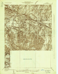 1932 Fairport1932 Print · USGSMonroe County's canal and rail corridor is captured here in the early 1930s, showing the vital intersection of the Barge Canal and major rail lines. Genealogists can locate family-named roads and numerous rural schools like School No 5 near Egypt.
 - 1934 Map of Fairport
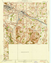 1934 Fairport1934 Print · USGSMonroe County was undergoing significant planning and growth in the early thirties as the canal and rail lines shaped the Rochester suburbs. Trace the locations of historic rural schoolhouses, the Bushnell Basin Guard Gate, and the South Perinton Ch.
 - 1934 Map of Honeoye Falls
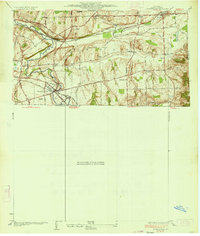 1934 Honeoye Falls1934 Print · USGSMonroe County and the surrounding valleys are shown here in the 1930s, centered on the village of Honeoye Falls. Local historians can trace early school districts and family plots at Quaker Cem, Graves Cem, and the old rail hub at Rochester Junction.
End of results
Showing maps 1-3 of 3
Top cities of Ontario County
- Victor historical maps
- Farmington historical maps
- Canandaigua historical maps
- Canandaigua historical maps
- Manchester historical maps
- Phelps historical maps
See more
Frequently asked questions
- What are the different types of historical maps available for Ontario County?
- What is the oldest map of Ontario County?
- Where can I purchase historical maps of Ontario County for my home or office?
- Where can I download high-res historical maps of Ontario County?
- Are there historical topographic maps available for Ontario County?
- Is there historical aerial imagery available for Ontario County?
- Where are historical maps of Ontario County sourced from?