1950s Maps of Ontario County, New York
Explore 20 historic maps of Ontario County from the 1950s. These maps offer a rare glimpse into what life looked like during the 1950s — showing old roads, neighborhoods, homes, and landmarks that have changed or disappeared over time.
Whether you're researching your family's past, planning a metal detecting trip, or studying how Ontario County's landscape evolved across the 1950s, these high-resolution maps are a powerful tool for exploring the history of this region.
- Focus on a specific era: All maps on this page are from the 1950s, giving you a focused view of this time period.
- See what’s changed: Compare century-old streets, trails, and buildings to today's modern landscape using overlays and satellite layers.
- Research with precision: Use these maps for genealogy, historical research, land use analysis, or educational projects.
- View, download, or print: Maps are fully viewable online in high resolution, and can be downloaded or printed for your own records.
Start exploring Ontario County's history through authentic maps from the 1950s. This is your window into the past.
Ontario County, NY maps
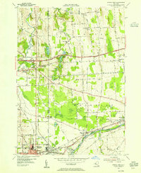
(20)- 1950 Map of Elmira
 1950 Elmira1950 Print · USGSThe Finger Lakes region thrived in the late 1940s as a hub of industry and transport. Trace family roots and vanished landmarks near Seneca Lake or explore the rail lines of the Erie RR and the sprawling Seneca Ordnance Depot.2 unique versions available
 - 1951 Map of Bristol Center, 1952 Print
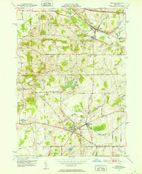
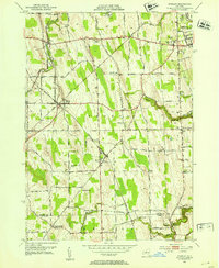
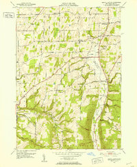 1951 Bristol Center1952 Print · USGSThe Bristol Valley region of Ontario County is shown in the early fifties as a landscape of rural crossroads and family-run hill farms. Researchers can trace ancestral locations through numerous burial sites like Andrews Cem and Case Cem, or locate old post points like Fletcher Corners.4 unique versions available
 - 1951 Map of Canandaigua, 1952 Print
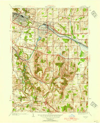
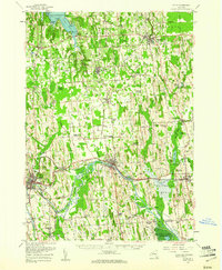
 1951 Canandaigua1952 Print · USGSMid-century Ontario County comes into focus as the city and its surrounding farmsteads transition into a new era. Researchers can trace ancestral roots through family burial grounds like Hathaway Cem and local landmarks such as South Farmington Chapel or McMillen Corners.3 unique versions available
 - 1951 Map of Canandaigua Lake, 1952 Print
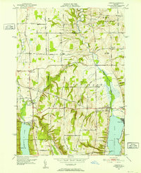
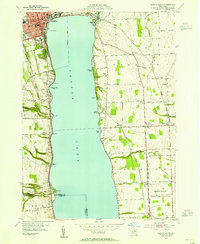
 1951 Canandaigua Lake1952 Print · USGSThe western shores of Canandaigua Lake are shown here in the early fifties, documenting a landscape of rural schools and lakeside summer colonies. Genealogists can locate family landmarks like Hunn Memorial Cemetery, Cheshire, and the various schoolhouses scattered among the gullies.4 unique versions available
 - 1951 Map of Honeoye Falls, 1952 Print
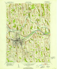
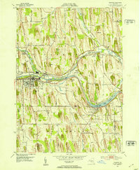
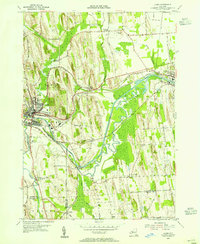
 1951 Honeoye Falls1952 Print · USGSThe Genesee Valley region comes to life in the early 1950s, showing the intersection of the rail-and-river economy just south of Rochester. Genealogists can locate several historic burial grounds like Quaker Cem and St Pauls Cem or trace family roots through landmarks such as Tomlinson Corners.2 unique versions available
 - 1951 Map of Victor, 1952 Print
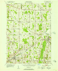
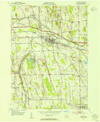
 1951 Victor1952 Print · USGSOntario County is captured here in the early fifties as the postwar highway system begins to overlay its historic rail corridors. Genealogists can locate family burial sites like Gunn Cem and Parker Cem alongside established settlements like Ionia and Holcomb.3 unique versions available
 - 1951 Map of Macedon, 1952 Print
 1951 Macedon1952 Print · USGSWayne County and northern Ontario County appear here in the early fifties, caught between their historic canal-era roots and mid-century growth. Researchers can trace the lineage of local hamlets and rural districts through landmarks like Yellow Mills, Walworth Station, and Farmington (Pumpkin Hook).4 unique versions available
 - 1951 Map of Honeoye, 1952 Print
 1951 Honeoye1952 Print · USGSThe Finger Lakes region of Upstate New York is captured here in the early 1950s, showing the settled valleys between Ontario and Livingston Counties. Researchers can trace historic family landmarks and community sites like St Marys Cem, School No 5 Hewitt, and the Fairgrounds near Hemlock.3 unique versions available
 - 1951 Map of Clifton Springs, 1953 Print
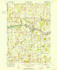
 1951 Clifton Springs1953 Print · USGSOntario County is captured in the early fifties as a bustling corridor of rail and industry along the Canandaigua Outlet. Trace the footprints of early residents at Riverview Cemetery, identify local schools like School No 1, or locate the historic County Home.3 unique versions available
 - 1952 Map of Rushville, 1953 Print
 1952 Rushville1953 Print · USGSThe rural Finger Lakes borderlands of Ontario and Yates counties are captured here in the early fifties, showing a landscape defined by farming and rail. Genealogists can trace family footprints through numerous cemeteries and crossroads like Reed Corners, Babbitt Corner, and Gorham.3 unique versions available
 - 1952 Map of Newark, 1953 Print
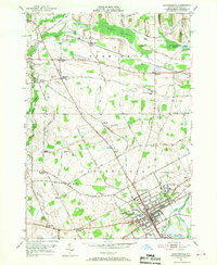
 1952 Newark1953 Print · USGSNewark and the surrounding Wayne County drumlins are captured in the early fifties, showing a landscape shaped by the Erie Canal and heavy rail. Researchers can locate vanished rural stops like Fairville Sta, the sprawling Newark State School, and historic burials at Old Hopper Cem.4 unique versions available
 - 1952 Map of Stanley, 1953 Print
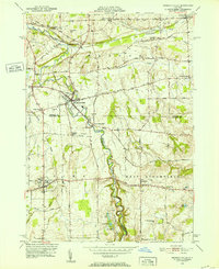
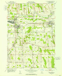
 1952 Stanley1953 Print · USGSThe rail junctions of Ontario County were in full operation in the early fifties, centering on the major crossing at Stanley. Genealogists and researchers can trace the rural school districts and family landmarks like Old No 9 Ch, Bellona, and the State Agricultural Experiment Station.2 unique versions available
 - 1952 Map of Palmyra, 1953 Print
 1952 Palmyra1953 Print · USGSMid-century Wayne County is shown here as a landscape of glacial drumlins and historic transport arteries. Genealogists and local historians can locate early schoolhouses like School No 11, family burial sites like Culver Cem, and landmarks such as Hill Cumorah.2 unique versions available
 - 1952 Map of Fairport, 1954 Print
 1952 Fairport1954 Print · USGSThe Erie Canal and major rail corridors define this Monroe County landscape in the early fifties, showing Fairport and East Rochester in a period of postwar growth. Genealogists and local historians can trace legacy sites from the South Perinton Ch to old crossroads like Egypt and Railroad Mills.4 unique versions available
 - 1953 Map of Phelps, 1954 Print
 1953 Phelps1954 Print · USGSOntario County’s agricultural and transit corridors are captured here in the early fifties, just as the modern thruway was reshaping the countryside. Genealogists and historians can locate numerous family burial grounds like Westfall Cem and Joslyn Cem or trace the early footprint of the State Agricultural Experiment Station.2 unique versions available
 - 1953 Map of Lyons, 1955 Print
 1953 Lyons1955 Print · USGSWayne County's canal and rail corridor is captured here in the early fifties, showing the industrial and agricultural landscape between Lyons and Clyde. Genealogists and historians can trace family-named sites like Fergusons Corners and Alloway, or locate the historic Lock Berlin and Elmwood Cem.3 unique versions available
 - 1953 Map of Geneva South, 1955 Print
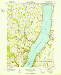
 1953 Geneva South1955 Print · USGSSeneca Lake and its surrounding Finger Lakes communities are shown here in the early fifties, caught between institutional growth and military expansion. Researchers can trace local lineage through Bachman Cem or map the boundaries of the Seneca Ordnance Depot and the Colleges of the Seneca.5 unique versions available
 - 1953 Map of Geneva North, 1955 Print
 1953 Geneva North1955 Print · USGSThe northern reaches of the Finger Lakes region are captured in the early fifties, showing the transition from traditional rail-and-canal transport to the interstate era. Researchers can trace ancestral farmsteads near Dublin and Stone Church Corner or locate vanished sites like the West Junius Station.4 unique versions available
 - 1953 Map of Clyde, 1961 Print
 1953 Clyde1961 Print · USGSWayne County is shown in the early fifties, defined by the industrial hubs of Lyons and Clyde along the historic Erie Canal. Researchers can trace old family sites at Lockwood Corners, locate the White Schoolhouse, or find the Rice Mill near the marshlands.
 - 1958 Map of Elmira
 1958 Elmira1958 Print · USGSThe New York Finger Lakes during the late fifties reveal a complex landscape of glacial geology and industrial growth. Researchers can trace historic transport corridors like the Erie Canal and Erie RR, or locate institutional landmarks like Cornell University.2 unique versions available
End of results
Showing maps 1-20 of 20
Top cities of Ontario County
- Victor historical maps
- Farmington historical maps
- Canandaigua historical maps
- Canandaigua historical maps
- Manchester historical maps
- Phelps historical maps
See more
Frequently asked questions
- What are the different types of historical maps available for Ontario County?
- What is the oldest map of Ontario County?
- Where can I purchase historical maps of Ontario County for my home or office?
- Where can I download high-res historical maps of Ontario County?
- Are there historical topographic maps available for Ontario County?
- Is there historical aerial imagery available for Ontario County?
- Where are historical maps of Ontario County sourced from?