1940s Maps of Ontario County, New York
Explore 20 historic maps of Ontario County from the 1940s. These maps offer a rare glimpse into what life looked like during the 1940s — showing old roads, neighborhoods, homes, and landmarks that have changed or disappeared over time.
Whether you're researching your family's past, planning a metal detecting trip, or studying how Ontario County's landscape evolved across the 1940s, these high-resolution maps are a powerful tool for exploring the history of this region.
- Focus on a specific era: All maps on this page are from the 1940s, giving you a focused view of this time period.
- See what’s changed: Compare century-old streets, trails, and buildings to today's modern landscape using overlays and satellite layers.
- Research with precision: Use these maps for genealogy, historical research, land use analysis, or educational projects.
- View, download, or print: Maps are fully viewable online in high resolution, and can be downloaded or printed for your own records.
Start exploring Ontario County's history through authentic maps from the 1940s. This is your window into the past.
Ontario County, NY maps
(20)- 1942 Map of Springwater
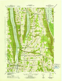 1942 Springwater1942 Print · USGSIn the early 1940s, the Finger Lakes region remained a patchwork of high-elevation farms and valley settlements. Genealogists can trace family names across Tabor Hill and locate long-standing institutions like School No 19 and Mt Vernon Cem.5 unique versions available
 - 1942 Map of Naples
 1942 Naples1942 Print · USGSSteuben County was a hub of rail traffic and valley farming in the early 1940s. Researchers can trace rural lineages through numerous local landmarks, including Flint Hill Cem, the Flischman Ch, and the dual lines of the Erie RR and D L & W RR.4 unique versions available
 - 1942 Map of Honeoye
 1942 Honeoye1942 Print · USGSThe Finger Lakes region comes to life in the early 1940s as lakeside settlements and hill-country farms define the local landscape. Genealogists and researchers can trace family landmarks like Short Cem, old school districts, and the path of the Lehigh Valley railroad through Hemlock.
 - 1942 Map of Prattsburg
 1942 Prattsburg1942 Print · USGSSteuben and Yates counties are documented here during the early war years, showing a landscape of upland farms and deep creek valleys. Genealogists can trace family roots through labeled landmarks like Segar Cem, School No 10, and the Italy-Naples Ch.3 unique versions available
 - 1942 Map of Victor
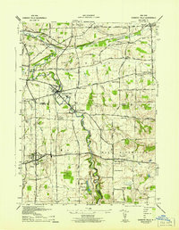
 1942 Victor1942 Print · USGSOntario County during the early 1940s reveals a landscape defined by the convergence of the Lehigh Valley and New York Central railroads. You can trace early family settlements and rural centers like Ionia, East Bloomfield, and the historic burial grounds at French Cem or Dibble Cem.
 - 1942 Map of Bristol Springs
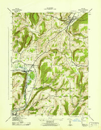
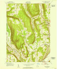
 1942 Bristol Springs1942 Print · USGSIn the uplands of Ontario County during the early 1940s, this landscape shows a network of hilltop farms and valley settlements before post-war changes. Researchers can locate several numbered schoolhouses, the Hunt Hollow Cem, and the LEHIGH VALLEY railroad line near Naples.
 - 1942 Map of Middlesex
 1942 Middlesex1942 Print · USGSThe eastern shores of Canandaigua Lake and the village of Middlesex are captured here during the early war years. Researchers can trace the Lehigh Valley rail line, find several rural burial grounds like Cove Cem, and locate numerous district schools.4 unique versions available
 - 1942 Map of Canandaigua
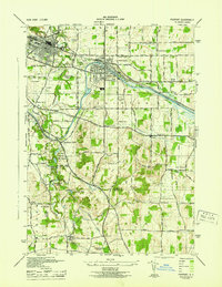
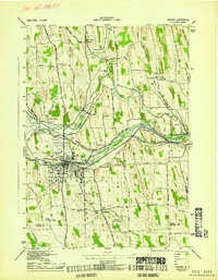
 1942 Canandaigua1942 Print · USGSOntario County is captured here in the early 1940s, showing the transition from the city of Canandaigua to the surrounding farm townships. Researchers can locate many family-named landmarks and rural hubs, including Farmington Station, South Farmington Chapel, and Ackley Cem.
 - 1942 Map of Canandaigua Lake
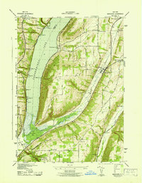
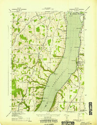 1942 Canandaigua Lake1942 Print · USGSCanandaigua Lake and its eastern and western shores are captured here during the early 1940s. Genealogists and local historians can trace the lakeside landings and rural family plots including Lucas Cem, Remington Cem, and the community at Cheshire.
 - 1942 Map of Rushville
 1942 Rushville1942 Print · USGSThe rural landscape of Ontario and Yates counties is meticulously detailed here in the early 1940s. Genealogists can locate family landmarks at Wilson Corners, trace ancestral burials at Washburn Cem, and follow the path of the Lehigh Valley Railroad.
 - 1942 Map of Honeoye Falls
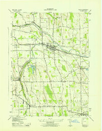
 1942 Honeoye Falls1942 Print · USGSWestern New York at the onset of the 1940s reveals a landscape of thriving rail hubs and rural crossroads villages. Genealogists can trace family names through landmarks like Quaker Cem or Graves Cem and locate historic rural schools such as School No 10.
 - 1942 Map of Stanley
 1942 Stanley1942 Print · USGSOntario and Yates counties intersect here during the early war years, revealing a landscape of rail-driven hamlets and productive farmland. Genealogists can trace family roots through the many rural school districts and old burial grounds like Sand Hill Cem or the Old Number Nine Church.
 - 1943 Map of Lyons
 1943 Lyons1943 Print · USGSThe village of Lyons and its neighboring hamlets are captured in the early 1940s during a period of transition for the historic Erie Canal. Researchers can trace old family sites at Fergusons Corners, local schoolhouses, and several burial grounds including Rural Cem.
 - 1943 Map of Geneva North
 1943 Geneva North1943 Print · USGSThe rural landscape north of Geneva is captured here in the early 1940s, showing a network of crossroads settlements and small-scale farms. Researchers can trace ancestral locations at Dobbins Corner, identify several local burying grounds like Quaker Cem, and locate numerous district schools such as School No 5.
 - 1943 Map of Geneva South
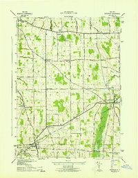
 1943 Geneva South1943 Print · USGSGeneva and the shores of Seneca Lake are captured here during the early 1940s, highlighting the region's academic and maritime identity. Researchers can trace the footprints of Hobart College, find local family names along Snell Road, or locate rail stops like Billsboro Sta.
 - 1943 Map of Phelps
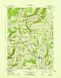
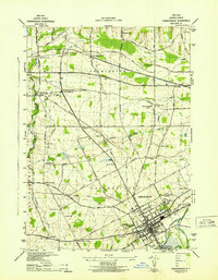
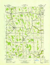
 1943 Phelps1943 Print · USGSOntario County thrived as a rail and agricultural hub during the mid-forties, captured here at a scale of 1:31,680. Researchers can trace the heritage of local hamlets like Seneca Castle, locate rural landmarks such as School No 7, or follow the path of the Lehigh Valley Railroad.
 - 1943 Map of Fairport
 1943 Fairport1943 Print · USGSFairport and the surrounding Perinton countryside are captured here during the Second World War as the canal and rail networks remained vital. Genealogists can locate numerous numbered rural schools and historic burial grounds like Parks Cem and St Marys Cem.
 - 1943 Map of Newark
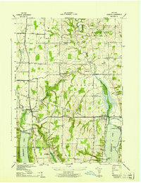
 1943 Newark1943 Print · USGSWayne County's canal and rail corridor is captured here during the Second World War, showing the critical junction at Newark. Genealogists and historians can trace the Newark State School, the Abd Erie Canal, and old rural landmarks like Mud Mills or Old Houser Cem.
 - 1943 Map of Palmyra
 1943 Palmyra1943 Print · USGSWayne County comes to life in the 1940s as a hub of canal transport and religious history. Genealogists can locate family landmarks like Langdon Cem, explore the district around Hill Cumorah, or trace the old route of the (NYC) Abd Erie Canal.
 - 1943 Map of Bristol Springs, 1953 Print
 1943 Bristol Springs1953 Print · USGSThe Finger Lakes uplands of Ontario County appear here just as the war years began, showing a landscape of high ridges and deep hollows. Researchers can find numerous district schoolhouses, family burial grounds like Hunt Hollow Cem, and the path of the Lehigh Valley railroad through Naples.4 unique versions available
End of results
Showing maps 1-20 of 20
Top cities of Ontario County
- Victor historical maps
- Farmington historical maps
- Canandaigua historical maps
- Canandaigua historical maps
- Manchester historical maps
- Phelps historical maps
See more
Frequently asked questions
- What are the different types of historical maps available for Ontario County?
- What is the oldest map of Ontario County?
- Where can I purchase historical maps of Ontario County for my home or office?
- Where can I download high-res historical maps of Ontario County?
- Are there historical topographic maps available for Ontario County?
- Is there historical aerial imagery available for Ontario County?
- Where are historical maps of Ontario County sourced from?