1940s Maps of South Bristol, New York
Explore 4 historic maps of South Bristol from the 1940s. These maps offer a rare glimpse into what life looked like during the 1940s — showing old roads, neighborhoods, homes, and landmarks that have changed or disappeared over time.
Whether you're researching your family's past, planning a metal detecting trip, or studying how South Bristol's landscape evolved across the 1940s, these high-resolution maps are a powerful tool for exploring the history of this region.
- Focus on a specific era: All maps on this page are from the 1940s, giving you a focused view of this time period.
- See what’s changed: Compare century-old streets, trails, and buildings to today's modern landscape using overlays and satellite layers.
- Research with precision: Use these maps for genealogy, historical research, land use analysis, or educational projects.
- View, download, or print: Maps are fully viewable online in high resolution, and can be downloaded or printed for your own records.
Start exploring South Bristol's history through authentic maps from the 1940s. This is your window into the past.
South Bristol, NY maps
(4)- 1942 Map of Bristol Springs
 1942 Bristol Springs1942 Print · USGSIn the uplands of Ontario County during the early 1940s, this landscape shows a network of hilltop farms and valley settlements before post-war changes. Researchers can locate several numbered schoolhouses, the Hunt Hollow Cem, and the LEHIGH VALLEY railroad line near Naples.
 - 1942 Map of Middlesex
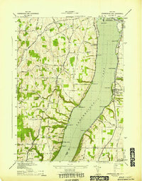
 1942 Middlesex1942 Print · USGSThe eastern shores of Canandaigua Lake and the village of Middlesex are captured here during the early war years. Researchers can trace the Lehigh Valley rail line, find several rural burial grounds like Cove Cem, and locate numerous district schools.4 unique versions available
 - 1942 Map of Canandaigua Lake
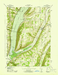
 1942 Canandaigua Lake1942 Print · USGSCanandaigua Lake and its eastern and western shores are captured here during the early 1940s. Genealogists and local historians can trace the lakeside landings and rural family plots including Lucas Cem, Remington Cem, and the community at Cheshire.
 - 1943 Map of Bristol Springs, 1953 Print
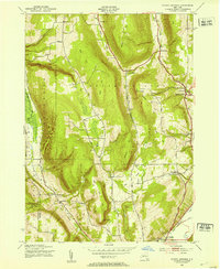 1943 Bristol Springs1953 Print · USGSThe Finger Lakes uplands of Ontario County appear here just as the war years began, showing a landscape of high ridges and deep hollows. Researchers can find numerous district schoolhouses, family burial grounds like Hunt Hollow Cem, and the path of the Lehigh Valley railroad through Naples.4 unique versions available
End of results
Showing maps 1-4 of 4
Top cities near South Bristol
- Canandaigua historical maps
- Canandaigua historical maps
- Livonia historical maps
- Jerusalem historical maps
- Lima historical maps
- Gorham historical maps
See more
Top neighborhoods of South Bristol
- Boswell Corners historical maps
- Bristol Springs historical maps
- Gulick historical maps
- Covel Corner historical maps
- Woodville historical maps
- Bristol Harbour Village historical maps
Frequently asked questions
- What are the different types of historical maps available for South Bristol?
- What is the oldest map of South Bristol?
- Where can I purchase historical maps of South Bristol for my home or office?
- Where can I download high-res historical maps of South Bristol?
- Are there historical topographic maps available for South Bristol?
- Is there historical aerial imagery available for South Bristol?
- Where are historical maps of South Bristol sourced from?