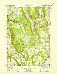
1942 Map of Bristol Springs
USGS Topo · Published 1942About this map
Gannett Hill and the dramatic ridge lines of South Bristol dominate this landscape, which was mapped during the early 1940s by the Tennessee Valley Authority for the Corps of Engineers. The area is characterized by deep ravines and steep slopes, most notably Briggs Gully and the unique landmark known as The Jumpoff. Settlement is concentrated at road intersections such as Boswell Corners, Semans Corners, and Brown Stand Corners, reflecting a rural economy tied to the land and the Lehigh Valley railroad corridor in the southeast.
Find a feature on this map
37 named features on this map. Tap any name to fly to it.
Don’t see what you’re looking for? This feature index may not catch every label — zoom into the map to look around manually.
Map Details
Editions of this 1942 Bristol Springs Map
This is the sole edition of this map. No revisions or reprints were ever made.
Other maps of this area

1900 · Naples
USGS Topo · 1:62,500

1900 · Canandaigua
USGS Topo · 1:62,500

1901 · Honeoye
USGS Topo · 1:62,500

1902 · Wayland
USGS Topo · 1:62,500

1903 · Naples
USGS Topo · 1:62,500

1903 · Canandaigua
USGS Topo · 1:62,500

1904 · Wayland
USGS Topo · 1:62,500

1904 · Honeoye
USGS Topo · 1:62,500

1913 · Naples
USGS Topo · 1:62,500

1942 · Springwater
USGS Topo · 1:31,680