1940s Maps of Cuddebackville, Deerpark
Explore 2 historic maps of Cuddebackville from the 1940s. These maps offer a rare glimpse into what life looked like during the 1940s — showing old roads, neighborhoods, homes, and landmarks that have changed or disappeared over time.
Whether you're researching your family's past, planning a metal detecting trip, or studying how Cuddebackville's landscape evolved across the 1940s, these high-resolution maps are a powerful tool for exploring the history of this region.
- Focus on a specific era: All maps on this page are from the 1940s, giving you a focused view of this time period.
- See what’s changed: Compare century-old streets, trails, and buildings to today's modern landscape using overlays and satellite layers.
- Research with precision: Use these maps for genealogy, historical research, land use analysis, or educational projects.
- View, download, or print: Maps are fully viewable online in high resolution, and can be downloaded or printed for your own records.
Start exploring Cuddebackville's history through authentic maps from the 1940s. This is your window into the past.
Cuddebackville, Deerpark maps
(2)- 1942 Map of Otisville, 1959 Print
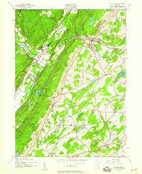 1942 Otisville1959 Print · USGSWestern Orange County during the early 1940s shows a landscape shaped by mountain ridges and the intersecting lines of the Erie RR and the New York Ontario and Western RR. Genealogists can locate family landmarks such as Mount Hope Cem or the local Godeffroy Sch.
 - 1943 Map of Otisville
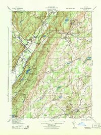 1943 Otisville1943 Print · USGSOrange and Sullivan Counties are shown in the 1940s as a hub of rail infrastructure and public health institutions. Researchers can trace the legacy of the N Y City Municipal Sanatorium, the Erie RR corridor, and local landmarks like Mount Hope Cemetery.
End of results
Showing maps 1-2 of 2
Top cities near Cuddebackville
- Warwick historical maps
- Wallkill historical maps
- Middletown historical maps
- Vernon Township historical maps
- Thompson historical maps
- Goshen historical maps
See more
Frequently asked questions
- What are the different types of historical maps available for Cuddebackville?
- What is the oldest map of Cuddebackville?
- Where can I purchase historical maps of Cuddebackville for my home or office?
- Where can I download high-res historical maps of Cuddebackville?
- Are there historical topographic maps available for Cuddebackville?
- Is there historical aerial imagery available for Cuddebackville?
- Where are historical maps of Cuddebackville sourced from?