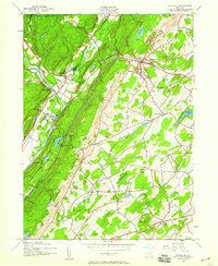
1942 Map of Otisville
USGS Topo · Published 1959About this map
The Shawangunk Mountains dominate the center of this terrain, creating a dramatic physical divide between the Neversink River valley and the rolling agricultural lands of eastern Orange County. During this wartime era, the area functioned as a vital transportation corridor, with the Erie RR and the New York Ontario and Western RR cutting through the landscape to serve the settlements of Otisville and Cuddebackville. These rail lines were essential for moving goods and people through the gap at Otisville, where the rails tunnel under the mountain ridges.
Find a feature on this map
42 named features on this map. Tap any name to fly to it.
Don’t see what you’re looking for? This feature index may not catch every label — zoom into the map to look around manually.
Map Details
Editions of this 1942 Otisville Map
This is the sole edition of this map. No revisions or reprints were ever made.
Other maps of this area

1904 · Ellenville
USGS Topo · 1:62,500

1906 · Ellenville
USGS Topo · 1:62,500

1906 · Port Jervis
USGS Topo · 1:62,500

1906 · Goshen
USGS Topo · 1:62,500

1908 · Goshen
USGS Topo · 1:62,500

1908 · Port Jervis
USGS Topo · 1:62,500

1909 · Monticello
USGS Topo · 1:62,500

1911 · Monticello
USGS Topo · 1:62,500

1938 · Goshen
USGS Topo · 1:62,500

1942 · Pine Island
USGS Topo · 1:24,000