1940s Maps of Randelville, Florida
Explore 2 historic maps of Randelville from the 1940s. These maps offer a rare glimpse into what life looked like during the 1940s — showing old roads, neighborhoods, homes, and landmarks that have changed or disappeared over time.
Whether you're researching your family's past, planning a metal detecting trip, or studying how Randelville's landscape evolved across the 1940s, these high-resolution maps are a powerful tool for exploring the history of this region.
- Focus on a specific era: All maps on this page are from the 1940s, giving you a focused view of this time period.
- See what’s changed: Compare century-old streets, trails, and buildings to today's modern landscape using overlays and satellite layers.
- Research with precision: Use these maps for genealogy, historical research, land use analysis, or educational projects.
- View, download, or print: Maps are fully viewable online in high resolution, and can be downloaded or printed for your own records.
Start exploring Randelville's history through authentic maps from the 1940s. This is your window into the past.
Randelville, Florida maps
(2)- 1943 Map of Warwick
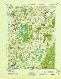 1943 Warwick1943 Print · USGSOrange County's agricultural and rail heartland is captured here during the mid-forties, showing the vital corridors between Warwick and Chester. Genealogists and researchers can locate the County Poor Farm, trace the ERIE railroad, and find local landmarks like Chester Academy and Albany School.2 unique versions available
 - 1946 Map of Goshen
 1946 Goshen1946 Print · USGSOrange County was a bustling crossroads of the Erie RR and several other lines during the early twentieth century. Genealogists and local historians can trace family-named hills and vanished rail stops from Pellets Island to Van Burenville and Stony Ford.
End of results
Showing maps 1-2 of 2
Top cities near Randelville
- Ramapo historical maps
- Haverstraw historical maps
- Kiryas Joel historical maps
- Palm Tree historical maps
- Warwick historical maps
- Newburgh historical maps
See more
Frequently asked questions
- What are the different types of historical maps available for Randelville?
- What is the oldest map of Randelville?
- Where can I purchase historical maps of Randelville for my home or office?
- Where can I download high-res historical maps of Randelville?
- Are there historical topographic maps available for Randelville?
- Is there historical aerial imagery available for Randelville?
- Where are historical maps of Randelville sourced from?