1950s Maps of Boylston, New York
Explore 6 historic maps of Boylston from the 1950s. These maps offer a rare glimpse into what life looked like during the 1950s — showing old roads, neighborhoods, homes, and landmarks that have changed or disappeared over time.
Whether you're researching your family's past, planning a metal detecting trip, or studying how Boylston's landscape evolved across the 1950s, these high-resolution maps are a powerful tool for exploring the history of this region.
- Focus on a specific era: All maps on this page are from the 1950s, giving you a focused view of this time period.
- See what’s changed: Compare century-old streets, trails, and buildings to today's modern landscape using overlays and satellite layers.
- Research with precision: Use these maps for genealogy, historical research, land use analysis, or educational projects.
- View, download, or print: Maps are fully viewable online in high resolution, and can be downloaded or printed for your own records.
Start exploring Boylston's history through authentic maps from the 1950s. This is your window into the past.
Boylston, NY maps
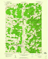
(6)- 1950 Map of Utica, 1951 Print
 1950 Utica1951 Print · USGSCentral New York in the post-war era showcases the industrial Mohawk Valley and the pristine Adirondack interior. Researchers can trace transportation networks like the New York Central Railroad and find early Cold War sites such as Griffiss Air Force Base.
 - 1957 Map of Utica
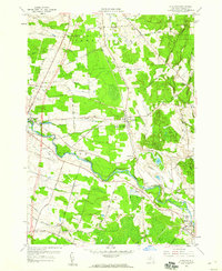
 1957 Utica1957 Print · USGSCentral New York and the Adirondack foothills are captured here in the mid-fifties, showing a landscape defined by the Mohawk River corridor and the growing highway system. Genealogists and researchers can trace the rail lines of the New York Central and locate communities from Lowville to Gloversville.
 - 1958 Map of Richland, 1960 Print
 1958 Richland1960 Print · USGSOswego County in the late fifties was defined by the New York Central railroad and the winding Salmon River. Local historians can trace old homesteads near Richland or locate family graves at Riverside Cem and Evergreen Cem.3 unique versions available
 - 1958 Map of Sandy Creek, 1960 Print
 1958 Sandy Creek1960 Print · USGSNorthern New York's agricultural and rail-dependent landscape comes alive in the late fifties as the New York Central Railroad links rural hubs. Researchers can trace ancestral locations from Pierrepont Manor to the Wesleyan Cem or locate the old Fairground near Sandy Creek.4 unique versions available
 - 1959 Map of Orwell, 1960 Print
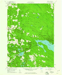 1959 Orwell1960 Print · USGSOswego County's mid-century landscape is defined here by the hydroelectric development of the Salmon River and the vast reforestation efforts across Boylston and Orwell. Researchers can trace rural life and industry through landmarks like Salmon River Falls, the settlement of Altmar, and the Powerhouse Sch.4 unique versions available
 - 1959 Map of Boylston Center, 1961 Print
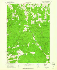 1959 Boylston Center1961 Print · USGSNorth-central New York's Tug Hill plateau transitions into managed forests and quiet hamlets during the late fifties. Genealogists and historians can trace old homesteads and landmarks like Boylston Center, St Josephs Ch, and the rural Phelps Cem.3 unique versions available
End of results
Showing maps 1-6 of 6
Top cities near Boylston
- Richland historical maps
- Adams historical maps
- Champion historical maps
- Sandy Creek historical maps
- Ellisburg historical maps
- Hounsfield historical maps
See more
Top neighborhoods of Boylston
- East Boylston historical maps
- Hemlock District historical maps
- Smartville historical maps
- Plantz Corners historical maps
- Boylston Center historical maps
- North Boylston historical maps
Frequently asked questions
- What are the different types of historical maps available for Boylston?
- What is the oldest map of Boylston?
- Where can I purchase historical maps of Boylston for my home or office?
- Where can I download high-res historical maps of Boylston?
- Are there historical topographic maps available for Boylston?
- Is there historical aerial imagery available for Boylston?
- Where are historical maps of Boylston sourced from?