Old Maps of Oswego County, New York
Explore 254 old maps of Oswego County, spanning from 1895 to today. These high-resolution historic maps reveal how streets, neighborhoods, landmarks, and natural features evolved over time — perfect for genealogy, metal detecting, research, and local history exploration.
What you can do with these maps:
- See how Oswego County changed over time: Compare historical maps to modern-day views to trace roads, homesites, rail lines & more.
- View detailed metadata: Each map includes creators, publishers, year, scale, and archive source.
- Overlay maps with satellite & LiDAR: Visualize the past alongside modern tools to explore terrain & human change.
- Trusted historical sources: Maps sourced from the USGS, Library of Congress, and other archives.
- Access maps your way: View online, download high-res files, or order prints for personal or research use.
Start exploring old maps of Oswego County to uncover forgotten places, hidden landmarks, and the deep history beneath your feet.
Oswego County, NY maps
(254)- 1895 Map of Chittenango
 1895 Chittenango1895 Print · USGSMadison County and the southern shores of Oneida Lake are shown here at the height of the canal and rail era. Researchers can trace the path of the Erie Canal through Chittenango and Canastota or locate vanished sites like Fyler Settlement.
 - 1895 Map of Stony Island
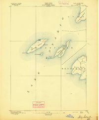 1895 Stony Island1895 Print · USGSLake Ontario's eastern islands and Jefferson County shoreline are documented in the 1890s as critical navigation points. Maritimers and local historians can trace the positions of the Galloup Id. L.H. and Stony Point L.H. among islands like Stony Island.6 unique versions available
 - 1895 Map of Pulaski
 1895 Pulaski1895 Print · USGSCoastal Oswego and Jefferson Counties are captured here in the late 1800s, where the Salmon River meets the lake. Genealogists can trace family roots through settlements like Richland, Pulaski, and the lakeside Life Saving Station.8 unique versions available
 - 1895 Map of Syracuse
 1895 Syracuse1895 Print · USGSSyracuse and the surrounding canal country are captured here in the late nineteenth century as the region thrived on salt production and rail traffic. Trace the vanished industrial Salt Sheds, the historic Erie Canal, and landmarks like the State Fair Grounds.
 - 1898 Map of Syracuse
 1898 Syracuse1898 Print · USGSSyracuse was a burgeoning railroad and canal junction at the end of the nineteenth century, surrounded by thriving villages and salt works. Genealogists and historians can trace family-named sites and vanished industrial works near the Salt Sheds, Cicero Swamp, and Fayetteville.10 unique versions available
 - 1898 Map of Chittenango
 1898 Chittenango1898 Print · USGSThe northern shore of Oneida Lake and the bustling Erie Canal corridor are captured here during the peak of New York's rail expansion. Researchers can trace the original canal path through Chittenango or locate vanished stops along the West Shore R. R. and Elmira and Cortland Br.
 - 1900 Map of Baldwinsville
 1900 Baldwinsville1900 Print · USGSOnondaga and Oswego counties are seen here at the close of the nineteenth century, when the Erie Canal still drove local commerce. Genealogists can trace family roots through canal towns like Jordan and river hubs like Baldwinsville and Phoenix.9 unique versions available
 - 1900 Map of Oswego
 1900 Oswego1900 Print · USGSThe Lake Ontario shoreline in Oswego and Cayuga Counties at the turn of the century is a hub of maritime and rail commerce. Genealogists and historians can trace the paths of four major railroads serving lakefront communities like North Fairhaven and the historic grounds of Fort Ontario.8 unique versions available
 - 1900 Map of Fulton
 1900 Fulton1900 Print · USGSOswego County at the turn of the century shows a bustling corridor of industry and agriculture along the Oswego River. Researchers can trace the legacy of vanished depots and hamlets like Bundy Crossing, Gilbert Mills, and Seneca Hill during the height of the steam-rail era.7 unique versions available
 - 1902 Map of Chittenango
 1902 Chittenango1902 Print · USGSMadison and Onondaga Counties are shown at a peak of rail and canal activity in the early 1900s. Genealogists and historians can trace the path of the Erie Canal through Canastota or locate smaller locales like Fyler Settlement and Quality Hill.7 unique versions available
 - 1903 Map of Orwell, 1955 Print
 1903 Orwell1955 Print · USGSOswego and Jefferson counties are documented here at the opening of the twentieth century, showing a landscape defined by the Tug Hill drainages. Genealogists and historians can trace the early footprints of Littlejohn Settlement, Otto Mills, and the falls at Stillwater.
 - 1905 Map of Orwell
 1905 Orwell1905 Print · USGSUpper Oswego and Jefferson counties are shown here in the early nineteen-hundreds as a landscape of remote settlements and river-powered valleys. Genealogists and historians can trace the exact locations of Little John Settlement, the Salmon Falls cataracts, and Bennett Bridge.6 unique versions available
 - 1905 Map of Mexico
 1905 Mexico1905 Print · USGSOswego County at the turn of the century shows a landscape of busy crossroads and emerging rail junctions. Genealogists can trace family footprints through numerous named settlements like Colosse, Howardville, and Union Settlement or locate old industrial sites like Carleys Mills.6 unique versions available
 - 1906 Map of Kasoag
 1906 Kasoag1906 Print · USGSOswego and Oneida counties are shown here in the early twentieth century as a thriving network of rail-linked hamlets and remote farmsteads. Researchers can trace old family locations near Florence Hill, North Amboy, and the State Fish Hatchery.7 unique versions available
 - 1940 Map of Brewerton
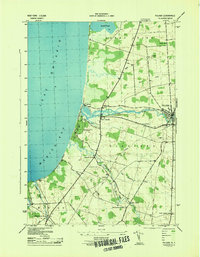
 1940 Brewerton1940 Print · USGSThe northern reaches of Onondaga County are captured here just before the war, centered on the historic Oneida River and canal systems. Researchers can trace the era's rural infrastructure through Woodard Sta, the Peat Swamp, and old landmarks like Morgan Ch.
 - 1940 Map of Cicero, 1957 Print
 1940 Cicero1957 Print · USGSOneida Lake’s southern shoreline was still largely rural and agricultural in the years before the war. Genealogists and local historians can trace family-named landmarks and early district schools like Van Anthrup Sch and the Cobblestone Sch.
 - 1941 Map of Cleveland
 1941 Cleveland1941 Print · USGSOneida Lake’s central waters and the surrounding shorelines are captured here in the early 1940s, highlighting a landscape of rail-connected villages and rural school districts. Genealogists can locate family landmarks like Smith Ridge Cem or trace the path of the New York Ontario and Western RR through Bernhard Bay.2 unique versions available
 - 1941 Map of Jewell
 1941 Jewell1941 Print · USGSOneida Lake shoreline communities in the early 1940s are documented here, showing a mix of established lakeside hamlets and inland farming hubs. Genealogists and local historians can locate early landmarks like Lakeport Chapel, West Church, and the rural Whitelaw Cem.
 - 1942 Map of Sandy Creek, 1957 Print
 1942 Sandy Creek1957 Print · USGSJefferson and Oswego Counties are shown during the early 1940s, when the New York Central rail line linked thriving rural hamlets. Family historians can locate several numbered schoolhouses and burial sites like Brewster Cem and Wesleyan Cem.
 - 1942 Map of Redfield, 1958 Print
 1942 Redfield1958 Print · USGSThe upland township of Redfield and its namesake reservoir are captured here during the early war years as a landscape of rural schools and winding river branches. Researchers can trace local family landmarks and infrastructure including Myrtle Cem, Otto Mills, and the sites of three numbered schoolhouses.
 - 1943 Map of Pulaski
 1943 Pulaski1943 Print · USGSOswego County's eastern lakeshore is captured during the early 1940s, showing the vital intersection of the Salmon River and the coast. Researchers can trace old family sites and rural infrastructure at Daysville Corner, School No 9, and Daysville Cem.
 - 1943 Map of Boylston
 1943 Boylston1943 Print · USGSUpper Oswego County is captured here in the 1940s, showing the rural communities of the Tug Hill plateau before mid-century changes. Researchers can locate numerous one-room schoolhouses, the Littlejohn State Game Refuge, and hamlets like Smartville and Winona.
 - 1943 Map of Oswego East
 1943 Oswego East1943 Print · USGSCoastal Oswego County was a landscape of small hamlets and family farmsteads during the Second World War. Genealogists can trace rural schoolhouse locations and several community burial grounds, including Kingdom Cem, Seneca Hill, and Bundy Crossing.
 - 1943 Map of Redfield
 1943 Redfield1943 Print · USGSOswego County's high country during the mid-forties shows a landscape of small mill sites and remote schoolhouses. Trace the early layout of Redfield and Otto Mills, or locate family sites like the Myrtle Cem and School No 9 along the Mad River.
 - 1943 Map of Lysander
 1943 Lysander1943 Print · USGSThe Seneca River valley in the early 1940s is shown here as a landscape of thriving rural hamlets and extensive canal infrastructure. Trace the network of old schoolhouses and cemeteries from Lysander to Plainville, or locate the family lands at Baird Corners.
Showing maps 1-25 of 254
Top cities of Oswego County
- Oswego historical maps
- Fulton historical maps
- Hastings historical maps
- Schroeppel historical maps
- Oswego historical maps
- Scriba historical maps
See more
Frequently asked questions
- What are the different types of historical maps available for Oswego County?
- What is the oldest map of Oswego County?
- Where can I purchase historical maps of Oswego County for my home or office?
- Where can I download high-res historical maps of Oswego County?
- Are there historical topographic maps available for Oswego County?
- Is there historical aerial imagery available for Oswego County?
- Where are historical maps of Oswego County sourced from?