Old Maps of Oswego County, New York for Genealogy
Trace your family roots with 134 historic maps of Oswego County. These high-res maps reveal old neighborhoods, homesites, landmarks, and streets — helping you uncover where your ancestors lived and how the area evolved over time.
- Explore historic neighborhoods: Identify where your relatives may have lived in the 1800s or 1900s.
- Compare maps over time: Trace the changes in streets, buildings, and landmarks for multi-generational research.
- Perfect for genealogy & ancestry research: Used by family historians and researchers to map out lineage and migration.
These maps are an incredible resource for exploring your personal connection to Oswego County's past.
Oswego County, NY maps
(134)- 1895 Map of Chittenango
 1895 Chittenango1895 Print · USGSCovers Oswego County, including Manlius, Cicero, and other nearby areas
 - 1895 Map of Stony Island
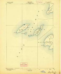 1895 Stony Island1895 Print · USGSCovers Oswego County, including Ellisburg, Hounsfield, and other nearby areas6 unique versions available
 - 1895 Map of Pulaski
 1895 Pulaski1895 Print · USGSCovers Oswego County, including Richland, Sandy Creek, and other nearby areas8 unique versions available
 - 1895 Map of Syracuse
 1895 Syracuse1895 Print · USGSCovers Oswego County, including Syracuse, Clay, and other nearby areas
 - 1898 Map of Syracuse
 1898 Syracuse1898 Print · USGSCovers Oswego County, including Syracuse, Clay, and other nearby areas10 unique versions available
 - 1898 Map of Chittenango
 1898 Chittenango1898 Print · USGSCovers Oswego County, including Manlius, Cicero, and other nearby areas
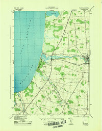
 - 1900 Map of Baldwinsville
 1900 Baldwinsville1900 Print · USGSCovers Oswego County, including Clay, Salina, and other nearby areas9 unique versions available
 - 1900 Map of Oswego
 1900 Oswego1900 Print · USGSCovers Oswego County, including Oswego, Oswego, and other nearby areas8 unique versions available
 - 1900 Map of Fulton
 1900 Fulton1900 Print · USGSCovers Oswego County, including Oswego, Fulton, and other nearby areas7 unique versions available
 - 1902 Map of Chittenango
 1902 Chittenango1902 Print · USGSCovers Oswego County, including Manlius, Cicero, and other nearby areas7 unique versions available
 - 1903 Map of Orwell, 1955 Print
 1903 Orwell1955 Print · USGSCovers Oswego County, including Albion, Williamstown, and other nearby areas
 - 1905 Map of Orwell
 1905 Orwell1905 Print · USGSCovers Oswego County, including Albion, Williamstown, and other nearby areas6 unique versions available
 - 1905 Map of Mexico
 1905 Mexico1905 Print · USGSCovers Oswego County, including Clay, Hastings, and other nearby areas6 unique versions available
 - 1906 Map of Kasoag
 1906 Kasoag1906 Print · USGSCovers Oswego County, including Vienna, Camden, and other nearby areas7 unique versions available
 - 1940 Map of Brewerton
 1940 Brewerton1940 Print · USGSCovers Oswego County, including Clay, Salina, and other nearby areas
 - 1940 Map of Cicero, 1957 Print
 1940 Cicero1957 Print · USGSCovers Oswego County, including Cicero, North Syracuse, and other nearby areas
 - 1941 Map of Cleveland
 1941 Cleveland1941 Print · USGSCovers Oswego County, including Cicero, Sullivan, and other nearby areas2 unique versions available
 - 1941 Map of Jewell
 1941 Jewell1941 Print · USGSCovers Oswego County, including Sullivan, Lenox, and other nearby areas
 - 1942 Map of Sandy Creek, 1957 Print
 1942 Sandy Creek1957 Print · USGSCovers Oswego County, including Sandy Creek, Ellisburg, and other nearby areas
 - 1942 Map of Redfield, 1958 Print
 1942 Redfield1958 Print · USGSCovers Oswego County, including Redfield, Osceola, and other nearby areas
 - 1943 Map of Pulaski
 1943 Pulaski1943 Print · USGSCovers Oswego County, including Richland, Sandy Creek, and other nearby areas
 - 1943 Map of Boylston
 1943 Boylston1943 Print · USGSCovers Oswego County, including Lorraine, Boylston, and other nearby areas
 - 1943 Map of Oswego East
 1943 Oswego East1943 Print · USGSCovers Oswego County, including Oswego, Oswego, and other nearby areas
 - 1943 Map of Redfield
 1943 Redfield1943 Print · USGSCovers Oswego County, including Redfield, Osceola, and other nearby areas
 - 1943 Map of Lysander
 1943 Lysander1943 Print · USGSCovers Oswego County, including Lysander, Van Buren, and other nearby areas
Showing maps 1-25 of 134
Top cities of Oswego County
- Oswego historical maps
- Fulton historical maps
- Hastings historical maps
- Schroeppel historical maps
- Oswego historical maps
- Scriba historical maps
See more
Frequently asked questions
- What are the different types of historical maps available for Oswego County?
- What is the oldest map of Oswego County?
- Where can I purchase historical maps of Oswego County for my home or office?
- Where can I download high-res historical maps of Oswego County?
- Are there historical topographic maps available for Oswego County?
- Is there historical aerial imagery available for Oswego County?
- Where are historical maps of Oswego County sourced from?