1970s Maps of Oswego County, New York
Explore 5 historic maps of Oswego County from the 1970s. These maps offer a rare glimpse into what life looked like during the 1970s — showing old roads, neighborhoods, homes, and landmarks that have changed or disappeared over time.
Whether you're researching your family's past, planning a metal detecting trip, or studying how Oswego County's landscape evolved across the 1970s, these high-resolution maps are a powerful tool for exploring the history of this region.
- Focus on a specific era: All maps on this page are from the 1970s, giving you a focused view of this time period.
- See what’s changed: Compare century-old streets, trails, and buildings to today's modern landscape using overlays and satellite layers.
- Research with precision: Use these maps for genealogy, historical research, land use analysis, or educational projects.
- View, download, or print: Maps are fully viewable online in high resolution, and can be downloaded or printed for your own records.
Start exploring Oswego County's history through authentic maps from the 1970s. This is your window into the past.
Oswego County, NY maps
(5)- 1973 Map of Brewerton, 1974 Print
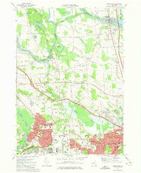 1973 Brewerton1974 Print · USGSOneida Lake and the riverfront communities of Clay and Brewerton are captured here during a period of significant suburban expansion in the 1970s. Local researchers can trace the growth of North Syracuse, locate Pine Plains Cem, or find the grounds of Fort Brewerton State Park.2 unique versions available
 - 1973 Map of Baldwinsville, 1974 Print
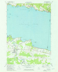
 1973 Baldwinsville1974 Print · USGSThe confluence of the Seneca, Oneida, and Oswego rivers defines this central New York landscape in the 1970s. Genealogists and historians can trace the foundations of Baldwinsville and Phoenix through sites like Riverside Cemetery, Bethel Ch, and the Oswego Canal.3 unique versions available
 - 1973 Map of Cicero, 1975 Print
 1973 Cicero1975 Print · USGSOneida Lake's southern shore and the expanding suburbs north of Syracuse come into focus during the early 1970s. Researchers can trace the mid-century growth of Cicero alongside landmarks like Hancock Field US Air Force and the Cicero Center Cem.4 unique versions available
 - 1973 Map of Cleveland, 1976 Print
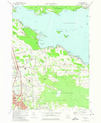
 1973 Cleveland1976 Print · USGSOneida Lake’s north and south shores are captured here in the early seventies, showing a landscape of quiet villages and expanding lakeside communities. Local historians can trace the Old RR Grade through Constantia, locate the Airfield (Aban'd) near Lakeport, or explore the wetland reaches of the Cicero Swamp.3 unique versions available
 - 1978 Map of Hannibal
 1978 Hannibal1978 Print · USGSThe intersection of Oswego and Cayuga counties comes into sharp focus during the late seventies, showing a landscape defined by crossroads hamlets and creek valleys. Researchers can trace local lineage through family sites like Mosher Cem and Bethel Cem, or locate landmarks such as Metcalf Siding and the Quarry.
End of results
Showing maps 1-5 of 5
Top cities of Oswego County
- Oswego historical maps
- Fulton historical maps
- Hastings historical maps
- Schroeppel historical maps
- Oswego historical maps
- Scriba historical maps
See more
Frequently asked questions
- What are the different types of historical maps available for Oswego County?
- What is the oldest map of Oswego County?
- Where can I purchase historical maps of Oswego County for my home or office?
- Where can I download high-res historical maps of Oswego County?
- Are there historical topographic maps available for Oswego County?
- Is there historical aerial imagery available for Oswego County?
- Where are historical maps of Oswego County sourced from?