1960s Maps of Oswego County, New York
Explore 11 historic maps of Oswego County from the 1960s. These maps offer a rare glimpse into what life looked like during the 1960s — showing old roads, neighborhoods, homes, and landmarks that have changed or disappeared over time.
Whether you're researching your family's past, planning a metal detecting trip, or studying how Oswego County's landscape evolved across the 1960s, these high-resolution maps are a powerful tool for exploring the history of this region.
- Focus on a specific era: All maps on this page are from the 1960s, giving you a focused view of this time period.
- See what’s changed: Compare century-old streets, trails, and buildings to today's modern landscape using overlays and satellite layers.
- Research with precision: Use these maps for genealogy, historical research, land use analysis, or educational projects.
- View, download, or print: Maps are fully viewable online in high resolution, and can be downloaded or printed for your own records.
Start exploring Oswego County's history through authentic maps from the 1960s. This is your window into the past.
Oswego County, NY maps
(11)- 1960 Map of Rochester
 1960 Rochester1960 Print · USGSThe Lake Ontario shoreline in the late fifties was a bustling corridor of rail and water commerce. Genealogists and historians can trace the path of the New York Central through canal towns like Newark or explore the coastal landmarks around Sackets Harbor.2 unique versions available
 - 1960 Map of Oswego, 1961 Print
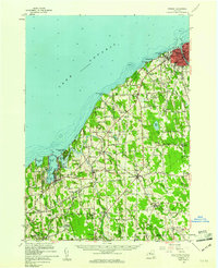 1960 Oswego1961 Print · USGSLake Ontario's southern shore and the busy port of Oswego are shown here during the early sixties. Researchers can trace the waterfront legacy of Fort Ontario, the New York Central tracks, and rural landmarks like St Joseph Chapel or School No 9.2 unique versions available
 - 1960 Map of Worth Center, 1962 Print
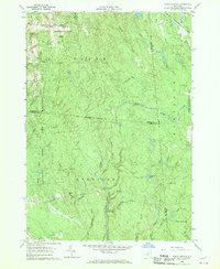 1960 Worth Center1962 Print · USGSThe Tug Hill region in the early sixties is shown as a densely forested landscape of state-managed lands and branching river systems. Researchers can trace the rural layout of Worth Center, the remote Littlejohn settlement, and the network of waters feeding the Mad River.4 unique versions available
 - 1960 Map of Williamstown, 1962 Print
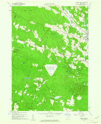
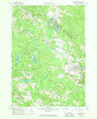 1960 Williamstown1962 Print · USGSOswego County in the early sixties is defined by its extensive reforestation areas and network of quiet glacial ponds. Researchers can trace the legacy of rural life through sites like Checkered House, Sch No 4, and the old Railroad Grade.3 unique versions available
 - 1960 Map of Redfield, 1962 Print
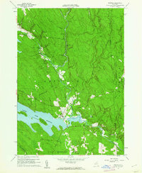 1960 Redfield1962 Print · USGSThe Tug Hill region of New York comes to life in the early sixties, showing the settlement of Redfield and the expansion of the Salmon River Reservoir. Genealogists and local historians can trace the paths of Waterbury Road to find Myrtle Cem or the industrial remnants at Otto Mills.4 unique versions available
 - 1960 Map of Camden West, 1962 Print
 1960 Camden West1962 Print · USGSOneida County's rural uplands and military test sites are captured here in the early sixties, showing a landscape shaped by both cold war defense and deep-rooted farming. Genealogists can locate family sites near Hillsboro, Lynch Cem, and the Temple Ch.3 unique versions available
 - 1961 Map of Rochester, 1973 Print
 1961 Rochester1973 Print · USGSThe Lake Ontario shoreline and Finger Lakes frontier are shown here at the height of the mid-century infrastructure boom. Genealogists and historians can trace the rail-and-road evolution from Sackets Harbor down to the New York State Thruway, passing through centers like Pulaski and Adams Center.3 unique versions available
 - 1962 Map of Utica
 1962 Utica1962 Print · USGSCentral New York and the Adirondack wilderness are captured here during the mid-century era of highway and industrial expansion. Genealogists and historians can trace the development of the New York State Thruway and local rail lines connecting Utica, Rome, and Gloversville.3 unique versions available
 - 1964 Map of Utica
 1964 Utica1964 Print · USGSCentral New York and the high wilderness of the Adirondacks are captured here during the post-war era of infrastructure expansion. Researchers can trace the development of the New York State Thruway alongside historic corridors like the Oneida Lake (Barge Canal Route) and the N. Y. Central railroad.
 - 1965 Map of Rochester
 1965 Rochester1965 Print · USGSUpstate New York's industrial heartland is captured here during a period of significant growth between the Great Lakes and the Finger Lakes. Genealogists and historians can trace the evolution of canal towns and rail hubs from Rochester to Syracuse, noting features like the Erie Canal and the New York State Thruway.
 - 1967 Map of Utica
 1967 Utica1967 Print · USGSCentral New York's industrial Mohawk Valley meets the Adirondack wilderness in the 1960s, showing the region's transition from manufacturing hubs to state-managed parklands. Trace historic settlements and sites like Griffiss Air Force Base, Colgate University, and the Lyons Falls Paper Mill.
End of results
Showing maps 1-11 of 11
Top cities of Oswego County
- Oswego historical maps
- Fulton historical maps
- Hastings historical maps
- Schroeppel historical maps
- Oswego historical maps
- Scriba historical maps
See more
Frequently asked questions
- What are the different types of historical maps available for Oswego County?
- What is the oldest map of Oswego County?
- Where can I purchase historical maps of Oswego County for my home or office?
- Where can I download high-res historical maps of Oswego County?
- Are there historical topographic maps available for Oswego County?
- Is there historical aerial imagery available for Oswego County?
- Where are historical maps of Oswego County sourced from?