2020s Maps of Oswego County, New York
Explore 30 historic maps of Oswego County from the 2020s. These maps offer a rare glimpse into what life looked like during the 2020s — showing old roads, neighborhoods, homes, and landmarks that have changed or disappeared over time.
Whether you're researching your family's past, planning a metal detecting trip, or studying how Oswego County's landscape evolved across the 2020s, these high-resolution maps are a powerful tool for exploring the history of this region.
- Focus on a specific era: All maps on this page are from the 2020s, giving you a focused view of this time period.
- See what’s changed: Compare century-old streets, trails, and buildings to today's modern landscape using overlays and satellite layers.
- Research with precision: Use these maps for genealogy, historical research, land use analysis, or educational projects.
- View, download, or print: Maps are fully viewable online in high resolution, and can be downloaded or printed for your own records.
Start exploring Oswego County's history through authentic maps from the 2020s. This is your window into the past.
Oswego County, NY maps
(30)- 2023 Map of Hannibal, 2023 Print
 2023 Hannibal2023 Print · USGSOswego and Cayuga Counties are shown here in the early twenty-first century, preserving a landscape of historic crossroads and rural hamlets. Local researchers can trace family landmarks and burial sites from Hannibal Cem to Pember Corners and the banks of Ninemile Creek.
 - 2023 Map of Central Square, 2023 Print
 2023 Central Square2023 Print · USGSOswego County's rural crossroads and riverfront hamlets are preserved here in the early twenty-first century. Genealogists can trace family sites like Hillside Cem or follow the historic waterways of the Oneida River and Big Bay Swamp.
 - 2023 Map of New Haven, 2023 Print
 2023 New Haven2023 Print · USGSOswego County hamlets and rural crossroads are preserved in this modern study of the landscape south of Lake Ontario. Researchers can locate numerous family burial sites and historical junctions including Haven Rural Cem, North Volney, and Butterfly Creek.
 - 2023 Map of Westdale, 2023 Print
 2023 Westdale2023 Print · USGSThe rural borderlands of Oneida, Oswego, and Lewis counties come to life in this contemporary survey of central New York. Researchers can locate family landmarks at Johnson Cem or trace the winding course of the Mad River past Florence.
 - 2023 Map of Panther Lake, 2023 Print
 2023 Panther Lake2023 Print · USGSOswego County's rural crossroads and glacial ponds are preserved here in the early twenty-first century. Genealogists and local historians can locate family burial grounds like Kinney Cem and trace the small-scale settlement patterns of Ducherville and Amboy Center.
 - 2023 Map of Worth Center, 2023 Print
 2023 Worth Center2023 Print · USGSThe headwaters of the Tug Hill region come into focus in the 2020s, showing a landscape of dense water networks and forest management. Researchers can trace the sprawling Little John Mgt Area Sthy and the remote roads near Worth Center.
 - 2023 Map of Williamstown, 2023 Print
 2023 Williamstown2023 Print · USGSOswego County's upland forests and numerous glacial ponds are captured here in a contemporary look at these rural New York hamlets. Genealogists and researchers can locate several family burial sites, including Madison Cem, White Cem, and Fairview Cem.
 - 2023 Map of Redfield, 2023 Print
 2023 Redfield2023 Print · USGSThe Salmon River watershed in Oswego County comes into sharp focus during the 2020s, showing the intersection of river islands and rural settlements. Researchers can locate Myrtle Cem and trace the winding paths of Mad River and Cold Brook.
 - 2023 Map of Orwell, 2023 Print
 2023 Orwell2023 Print · USGSOswego County's upland terrain and river valleys are captured here in the early twenty-first century, showing a landscape defined by water and woods. Researchers can trace family sites at Pekin and Chateaugay or locate the historic Riverside Cem near Altmar.
 - 2023 Map of Oswego West, 2023 Print
 2023 Oswego West2023 Print · USGSThe lakefront at Oswego and its surrounding townships are shown in detail as they appeared in the early 2020s. Genealogists can trace several local burial grounds including Rice Cem and Stevens Cem or the sprawling SUNY Oswego campus.
 - 2023 Map of Camden West, 2023 Print
 2023 Camden West2023 Print · USGSOneida County at the dawn of the 2020s remains a landscape of historic hamlets and sprawling wetlands. Genealogists and local historians can trace the rural layout of Elpis and Hillsboro or locate family sites at Temple Cem and Lynch Cem.
 - 2023 Map of Jewell, 2023 Print
 2023 Jewell2023 Print · USGSThe central shoreline of Oneida Lake is shown here in the 2020s, bridging the borders of Oswego, Oneida, and Madison counties. Local historians can trace family cemeteries like Lakewood Cem and shoreline landmarks from Jewell to Lakeport.
 - 2023 Map of Baldwinsville, 2023 Print
 2023 Baldwinsville2023 Print · USGSUpper New York state watercraft and rail history intersect at the junction of the Seneca River and Oneida River in the early twenty-first century. Researchers can trace ancestral sites at Saint Marys Cem and Chase Cem, or explore local landmarks like Lane Airport.
 - 2023 Map of Dugway, 2023 Print
 2023 Dugway2023 Print · USGSOswego County's agricultural and riverine landscape is captured here in the early twenty-first century, showing the small hubs of Parish and Dugway. Local researchers can trace family sites and old boundaries near Albion Center Cem, Carley Mills, and Saint Marys Pond.
 - 2023 Map of Richland, 2023 Print
 2023 Richland2023 Print · USGSOswego County's river-fed landscape is captured here in the early twenty-first century, centered on the historic crossroads of Richland and the Salmon River. Researchers can locate numerous burial sites like Stevens Cem and Salmon River Cem or trace local landmarks like Richland Airpark.
 - 2023 Map of Cleveland, 2023 Print
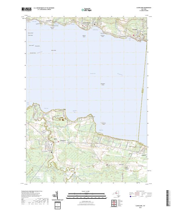 2023 Cleveland2023 Print · USGSThe north and south shores of Oneida Lake are captured here in the early 2020s, showing the enduring waterfront communities of Constantia and Cleveland. Researchers can locate several burial grounds including Deyo Cem and Smith's Ridge Cem or trace the drainage of Chittenango Creek into the lake.
 - 2023 Map of Fulton, 2023 Print
 2023 Fulton2023 Print · USGSThis recent survey of the Oswego River valley captures the industrial and agricultural landscape of central New York. Researchers can trace family history through several local burial grounds like Mount Abnah Cem or explore the shoreline of Lake Neatahwanta.
 - 2023 Map of Sandy Creek, 2023 Print
 2023 Sandy Creek2023 Print · USGSThe border of Jefferson and Oswego counties is captured here in the early twenty-first century, showing the enduring settlement patterns of the Tug Hill foothills. Local historians can trace old homesteads and roads near Pierrepont Manor, Cobbtown, and the Woodlawn Cem.
 - 2023 Map of Lysander, 2023 Print
 2023 Lysander2023 Print · USGSThe Seneca River valley and its surrounding hamlets are captured here in the early twenty-first century. Genealogists and historians can trace family roots through the Plainville Rural Cem and Old Presbyterian Cem, or locate long-standing crossroads like Baird Corners.
 - 2023 Map of West of Texas, 2023 Print
 2023 West of Texas2023 Print · USGSThe Lake Ontario shoreline in Oswego County is documented here in the early twenty-first century. Researchers can trace the coastal layout of Lakeview and find specific local landmarks like Sunset Bay and Scriba Town Park Rd.
 - 2023 Map of Mallory, 2023 Print
 2023 Mallory2023 Print · USGSNorthern Oneida Lake settlements are documented here during the early twenty-first century. Genealogists can trace family names through Carley Mills Cem and hamlets like Little France, Union Settlement, and Mud Settlement.
 - 2023 Map of Pulaski, 2023 Print
 2023 Pulaski2023 Print · USGSThe eastern shore of Lake Ontario comes into focus here in the early 2020s, centered on the historic village of Pulaski and its connection to the Salmon River. Researchers can trace local lineage through several landmarks like Brown's Landing Cem, Daysville, and the extensive Deer Creek Wildlife Mgt Area.
 - 2023 Map of Oswego East, 2023 Print
 2023 Oswego East2023 Print · USGSThe eastern reaches of Oswego and the rural interior of Scriba come into sharp focus in this modern survey of the Lake Ontario shoreline. Researchers can trace burial sites from Riverside Cem to Blossom Cem or locate families near Seneca Hill and Walker.
 - 2023 Map of Mexico, 2023 Print
 2023 Mexico2023 Print · USGSOswego County's agricultural heartland and river networks are captured here in the early twenty-first century. Researchers can trace ancestral lines through numerous burial sites like Mexico Village Cemetery and Quaker Cem or locate old crossroads at Graftons Square and Colosse.
 - 2023 Map of Texas, 2023 Print
 2023 Texas2023 Print · USGSThe Oswego County shoreline along Lake Ontario is captured here in the early twenty-first century. Researchers can trace the layout of small lakeside communities like Texas and Shore Oaks, or locate the Parker Ramsey Stevens Cem.
Showing maps 1-25 of 30
Top cities of Oswego County
- Oswego historical maps
- Fulton historical maps
- Hastings historical maps
- Schroeppel historical maps
- Oswego historical maps
- Scriba historical maps
See more
Frequently asked questions
- What are the different types of historical maps available for Oswego County?
- What is the oldest map of Oswego County?
- Where can I purchase historical maps of Oswego County for my home or office?
- Where can I download high-res historical maps of Oswego County?
- Are there historical topographic maps available for Oswego County?
- Is there historical aerial imagery available for Oswego County?
- Where are historical maps of Oswego County sourced from?