Old Maps of North Constantia, Constantia for Metal Detecting
Plan your next treasure hunt with 14 historic maps of North Constantia. Find old homesites, ghost towns, trails, and gathering spots that may be lost to time — perfect for identifying promising metal detecting locations.
- Locate forgotten sites: Uncover places like long-lost settlements, abandoned rail lines, or gathering spots.
- Plan better hunts: Use map overlays combined with LiDAR or satellite views to narrow in on historically rich areas.
- Made for detectorists: Thousands of hobbyists use these maps to discover relics, coins, and hidden history.
Use these historic maps to boost your research and find new opportunities beneath the surface of North Constantia.
North Constantia, Constantia maps
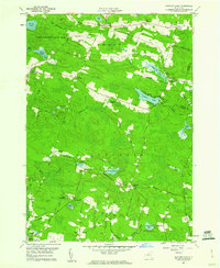
(14)- 1906 Map of Kasoag
 1906 Kasoag1906 Print · USGSOswego and Oneida counties are shown here in the early twentieth century as a thriving network of rail-linked hamlets and remote farmsteads. Researchers can trace old family locations near Florence Hill, North Amboy, and the State Fish Hatchery.7 unique versions available
 - 1943 Map of Panther Lake
 1943 Panther Lake1943 Print · USGSOswego County's wooded lake country is shown in detail during the early 1940s, featuring a landscape of small hamlets and numerous rural schoolhouses. Genealogists can trace family landmarks and local centers like Amboy Center, Dutcherville, and the Hall Cem.
 - 1950 Map of Utica, 1951 Print
 1950 Utica1951 Print · USGSCentral New York in the post-war era showcases the industrial Mohawk Valley and the pristine Adirondack interior. Researchers can trace transportation networks like the New York Central Railroad and find early Cold War sites such as Griffiss Air Force Base.
 - 1957 Map of Utica
 1957 Utica1957 Print · USGSCentral New York and the Adirondack foothills are captured here in the mid-fifties, showing a landscape defined by the Mohawk River corridor and the growing highway system. Genealogists and researchers can trace the rail lines of the New York Central and locate communities from Lowville to Gloversville.
 - 1959 Map of Panther Lake, 1960 Print
 1959 Panther Lake1960 Print · USGSOswego County is shown in transition during the late fifties, where reforestation efforts and timberlands met a scattering of small lakeside hamlets. Researchers can trace family history through Hall Cem and old crossroads like Dutcherville or Jamison Corners.3 unique versions available
 - 1962 Map of Utica
 1962 Utica1962 Print · USGSCentral New York and the Adirondack wilderness are captured here during the mid-century era of highway and industrial expansion. Genealogists and historians can trace the development of the New York State Thruway and local rail lines connecting Utica, Rome, and Gloversville.3 unique versions available
 - 1964 Map of Utica
 1964 Utica1964 Print · USGSCentral New York and the high wilderness of the Adirondacks are captured here during the post-war era of infrastructure expansion. Researchers can trace the development of the New York State Thruway alongside historic corridors like the Oneida Lake (Barge Canal Route) and the N. Y. Central railroad.
 - 1967 Map of Utica
 1967 Utica1967 Print · USGSCentral New York's industrial Mohawk Valley meets the Adirondack wilderness in the 1960s, showing the region's transition from manufacturing hubs to state-managed parklands. Trace historic settlements and sites like Griffiss Air Force Base, Colgate University, and the Lyons Falls Paper Mill.
 - 1985 Map of Utica, 1986 Print
 1985 Utica1986 Print · USGSThe Mohawk Valley in the mid-eighties shows a landscape of industrial river cities and high-tech military hubs before the post-Cold War transition. Trace the development of Rome and Utica, the operations at Griffiss Air Force Base, and the lakeside activity at Oneida Lake.2 unique versions available
 - 2010 Map of Panther Lake, 2010 Print
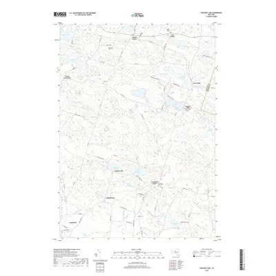
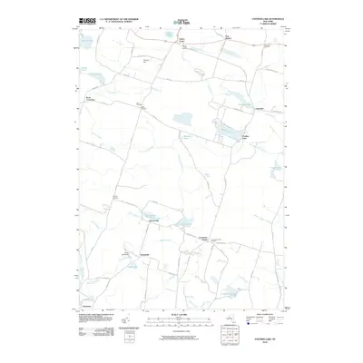 2010 Panther Lake2010 Print · USGSCovers North Constantia, including Camden, Constantia, and other nearby areas
 - 2013 Map of Panther Lake, 2013 Print
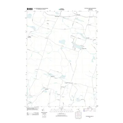 2013 Panther Lake2013 Print · USGSCovers North Constantia, including Camden, Constantia, and other nearby areas
 - 2016 Map of Panther Lake, 2016 Print
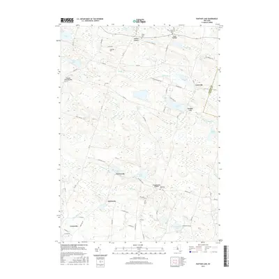 2016 Panther Lake2016 Print · USGSCovers North Constantia, including Camden, Constantia, and other nearby areas
 - 2019 Map of Panther Lake, 2019 Print
 2019 Panther Lake2019 Print · USGSCovers North Constantia, including Camden, Constantia, and other nearby areas
 - 2023 Map of Panther Lake, 2023 Print
 2023 Panther Lake2023 Print · USGSOswego County's rural crossroads and glacial ponds are preserved here in the early twenty-first century. Genealogists and local historians can locate family burial grounds like Kinney Cem and trace the small-scale settlement patterns of Ducherville and Amboy Center.
End of results
Showing maps 1-14 of 14
Top cities near North Constantia
- Clay historical maps
- Manlius historical maps
- Salina historical maps
- Cicero historical maps
- De Witt historical maps
- Geddes historical maps
See more
Frequently asked questions
- What are the different types of historical maps available for North Constantia?
- What is the oldest map of North Constantia?
- Where can I purchase historical maps of North Constantia for my home or office?
- Where can I download high-res historical maps of North Constantia?
- Are there historical topographic maps available for North Constantia?
- Is there historical aerial imagery available for North Constantia?
- Where are historical maps of North Constantia sourced from?