1940s Maps of Granby, New York
Explore 6 historic maps of Granby from the 1940s. These maps offer a rare glimpse into what life looked like during the 1940s — showing old roads, neighborhoods, homes, and landmarks that have changed or disappeared over time.
Whether you're researching your family's past, planning a metal detecting trip, or studying how Granby's landscape evolved across the 1940s, these high-resolution maps are a powerful tool for exploring the history of this region.
- Focus on a specific era: All maps on this page are from the 1940s, giving you a focused view of this time period.
- See what’s changed: Compare century-old streets, trails, and buildings to today's modern landscape using overlays and satellite layers.
- Research with precision: Use these maps for genealogy, historical research, land use analysis, or educational projects.
- View, download, or print: Maps are fully viewable online in high resolution, and can be downloaded or printed for your own records.
Start exploring Granby's history through authentic maps from the 1940s. This is your window into the past.
Granby, NY maps
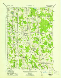
(6)- 1943 Map of Lysander
 1943 Lysander1943 Print · USGSThe Seneca River valley in the early 1940s is shown here as a landscape of thriving rural hamlets and extensive canal infrastructure. Trace the network of old schoolhouses and cemeteries from Lysander to Plainville, or locate the family lands at Baird Corners.
 - 1943 Map of Pennellville
 1943 Pennellville1943 Print · USGSOswego County is captured here during the Second World War, showing a rural landscape organized around the New York Ontario and Western Railroad. Genealogists can trace family names at Farley Corners and Bowen Corners, or locate long-gone schoolhouses like School No 5.
 - 1943 Map of Hannibal
 1943 Hannibal1943 Print · USGSOswego and Cayuga counties are shown here during the war years, when the landscape was a dense network of family farms and rural school districts. Genealogists can trace family footprints through numerous numbered schools and local landmarks like Bethel Cem, Martville, and the Lehigh Valley railroad line.2 unique versions available
 - 1943 Map of Baldwinsville
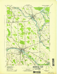 1943 Baldwinsville1943 Print · USGSCentral New York’s river-and-rail economy is on full display during the war years at the meeting of the Seneca and Oneida Rivers. Genealogists can trace local roots through numerous family cemeteries and numbered schoolhouses like School No 2 and Riverside Cem.
 - 1943 Map of Fulton
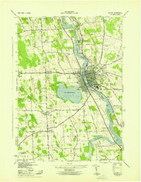 1943 Fulton1943 Print · USGSFulton and the Oswego River valley are shown in detail during the early 1940s, highlighting a landscape where industry and rural life meet. Local historians can trace the paths of three railroads or find family sites near Mt Adnah Cem and Lewis Corners.
 - 1948 Map of Baldwinsville
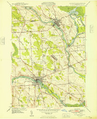 1948 Baldwinsville1948 Print · USGSThe confluence of the Seneca, Oneida, and Oswego Rivers defines this late 1940s landscape of central New York. Genealogists can locate family landmarks like Rouse Cem, St Marys Cem, and several local schoolhouses from Belgium to Phoenix.
End of results
Showing maps 1-6 of 6
Top cities near Granby
- Syracuse historical maps
- Clay historical maps
- Salina historical maps
- Camillus historical maps
- Lysander historical maps
- Geddes historical maps
See more
Top neighborhoods of Granby
- Pember Corners historical maps
- Granby Center historical maps
- Lewis Corners historical maps
- Hinmansville historical maps
- South Granby historical maps
- Bowens Corners historical maps
See more
Frequently asked questions
- What are the different types of historical maps available for Granby?
- What is the oldest map of Granby?
- Where can I purchase historical maps of Granby for my home or office?
- Where can I download high-res historical maps of Granby?
- Are there historical topographic maps available for Granby?
- Is there historical aerial imagery available for Granby?
- Where are historical maps of Granby sourced from?