1940s Maps of Redfield, New York
Explore 8 historic maps of Redfield from the 1940s. These maps offer a rare glimpse into what life looked like during the 1940s — showing old roads, neighborhoods, homes, and landmarks that have changed or disappeared over time.
Whether you're researching your family's past, planning a metal detecting trip, or studying how Redfield's landscape evolved across the 1940s, these high-resolution maps are a powerful tool for exploring the history of this region.
- Focus on a specific era: All maps on this page are from the 1940s, giving you a focused view of this time period.
- See what’s changed: Compare century-old streets, trails, and buildings to today's modern landscape using overlays and satellite layers.
- Research with precision: Use these maps for genealogy, historical research, land use analysis, or educational projects.
- View, download, or print: Maps are fully viewable online in high resolution, and can be downloaded or printed for your own records.
Start exploring Redfield's history through authentic maps from the 1940s. This is your window into the past.
Redfield, NY maps
(8)- 1942 Map of Redfield, 1958 Print
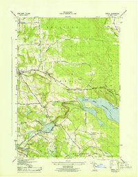
 1942 Redfield1958 Print · USGSThe upland township of Redfield and its namesake reservoir are captured here during the early war years as a landscape of rural schools and winding river branches. Researchers can trace local family landmarks and infrastructure including Myrtle Cem, Otto Mills, and the sites of three numbered schoolhouses.
 - 1943 Map of Boylston
 1943 Boylston1943 Print · USGSUpper Oswego County is captured here in the 1940s, showing the rural communities of the Tug Hill plateau before mid-century changes. Researchers can locate numerous one-room schoolhouses, the Littlejohn State Game Refuge, and hamlets like Smartville and Winona.
 - 1943 Map of Redfield
 1943 Redfield1943 Print · USGSOswego County's high country during the mid-forties shows a landscape of small mill sites and remote schoolhouses. Trace the early layout of Redfield and Otto Mills, or locate family sites like the Myrtle Cem and School No 9 along the Mad River.
 - 1943 Map of Westdale
 1943 Westdale1943 Print · USGSOneida County at the height of the Second World War reveals a landscape of small farming hamlets and a robust network of district schools. Genealogists can trace family roots through sites like Graves Cem, Union Ch, and settlements such as Westdale or Spellicy.
 - 1943 Map of Worth Center
 1943 Worth Center1943 Print · USGSThe Tug Hill plateau at the height of the Second World War reveals a landscape of isolated homesteads and expanding conservation lands. Genealogists and hikers can trace the old roads near Worth Center, School No 4, and the Lookout Tower.
 - 1943 Map of Williamstown
 1943 Williamstown1943 Print · USGSOswego County's rural landscape during the mid-1940s reveals a community centered on the New York Central rail line and a network of district schools. Researchers can trace family sites near Holy Cross Cem, find old landmarks like the Checkered House, and explore the shoreline of Kasoag Lake.
 - 1943 Map of Orwell, 1957 Print
 1943 Orwell1957 Print · USGSIn the early 1940s, the rural hills of Oswego County were defined by the deep waters of the Salmon River Reservoir and its surrounding forests. Researchers can trace the era's local life through numerous rural school sites and the historic Vorea Post Office or explore the hydro-power history near Bennett Bridge.2 unique versions available
 - 1946 Map of Westdale, 1953 Print
 1946 Westdale1953 Print · USGSOneida County's rural heartland is captured here just after the war, showing the network of hill-country hamlets and district schools. Trace family roots and vanished landmarks near Westdale, Union Ch, and the many rural schoolhouses like School No 5.
End of results
Showing maps 1-8 of 8
Top cities near Redfield
- Richland historical maps
- Adams historical maps
- Camden historical maps
- West Monroe historical maps
- Sandy Creek historical maps
- Ellisburg historical maps
See more
Top neighborhoods of Redfield
Frequently asked questions
- What are the different types of historical maps available for Redfield?
- What is the oldest map of Redfield?
- Where can I purchase historical maps of Redfield for my home or office?
- Where can I download high-res historical maps of Redfield?
- Are there historical topographic maps available for Redfield?
- Is there historical aerial imagery available for Redfield?
- Where are historical maps of Redfield sourced from?