1900s (20th Century) Maps of Otsego County, New York
Explore 95 historic maps of Otsego County from the 1900s (20th Century). These maps offer a rare glimpse into what life looked like during the 1900s — showing old roads, neighborhoods, homes, and landmarks that have changed or disappeared over time.
Whether you're researching your family's past, planning a metal detecting trip, or studying how Otsego County's landscape evolved across the 1900s, these high-resolution maps are a powerful tool for exploring the history of this region.
- Focus on a specific era: All maps on this page are from the 1900s, giving you a focused view of this time period.
- See what’s changed: Compare century-old streets, trails, and buildings to today's modern landscape using overlays and satellite layers.
- Research with precision: Use these maps for genealogy, historical research, land use analysis, or educational projects.
- View, download, or print: Maps are fully viewable online in high resolution, and can be downloaded or printed for your own records.
Start exploring Otsego County's history through authentic maps from the 1900s. This is your window into the past.
Otsego County, NY maps
(95)- 1900 Map of Canajoharie
 1900 Canajoharie1900 Print · USGSThe Mohawk Valley at the turn of the century shows a dense network of canal, rail, and river transportation. Genealogists can trace family footprints in historic Canajoharie, the upland farms near Stone Arabia, and the resort area of Sharon Springs.
 - 1902 Map of Canajoharie
 1902 Canajoharie1902 Print · USGSThe Mohawk Valley was a bustling corridor of canal traffic and steam power just after the turn of the century. Genealogists can trace family names and farmsteads near Stone Arabia or explore the resort layout of Sharon Springs and the industrial hubs of Ft. Plain and Canajoharie.6 unique versions available
 - 1903 Map of Richfield Springs
 1903 Richfield Springs1903 Print · USGSThe northern Otsego County landscape at the turn of the century shows a bustling rural economy centered around the headwaters of the Susquehanna. Researchers can trace the early Steamboat Route on Otsego Lake and explore rail-era depots like Richfield Springs and Cherry Valley.6 unique versions available
 - 1904 Map of Richmondville
 1904 Richmondville1904 Print · USGSSchoharie and Otsego counties appear here at the start of the century as the rail-and-river economy reached its peak. Genealogists can trace family footprints through historic hamlets like Lutheranville, Seward, and South Valley along the Delaware and Hudson RR.5 unique versions available
 - 1907 Map of Winfield
 1907 Winfield1907 Print · USGSCentral New York's dairy and rail corridor is captured here at the start of the century. Genealogists can trace family names across hamlets like Millers Mills and Plainfield Center, or locate old depots along the Unadilla Valley RR.6 unique versions available
 - 1907 Map of Sangerfield
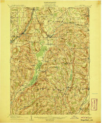 1907 Sangerfield1907 Print · USGSOneida and Madison counties meet at the height of the central New York hills in the early twentieth century. Genealogists and local historians can trace the positions of the Budlong Schoolhouse, the industrial activity at Mains Mills, and the path of the Cherry Valley Turnpike.6 unique versions available
 - 1907 Map of Cooperstown, 1960 Print
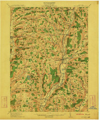
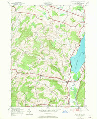
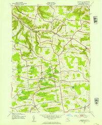
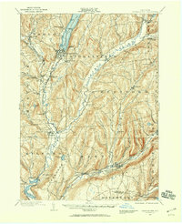 1907 Cooperstown1960 Print · USGSOtsego County at the start of the twentieth century remains centered on its historic waterways and early rail corridors. Genealogists can trace family names through landmarks like Hartwick Seminary, Phoenix Mills, and the Lakewood Cemetery near the lake shore.
 - 1909 Map of Cooperstown
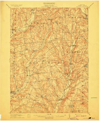
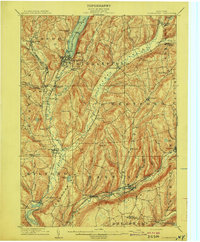 1909 Cooperstown1909 Print · USGSOtsego County at the start of the twentieth century shows a landscape of deep valleys shaped by the Susquehanna and rail travel. Genealogists can trace family names and early sites like Hartwick Seminary, the County House, and the Kingfisher Tower.6 unique versions available
 - 1909 Map of Delhi, 1963 Print
 1909 Delhi1963 Print · USGSDelaware County at the turn of the century is a landscape of valley railroads and high ridgeline farms. Genealogists and researchers can trace family lands near Elk Creek Church, follow the old Ulster and Delaware RR line, or locate early sites in Delhi and Meridale.
 - 1910 Map of Hartwick, 1953 Print
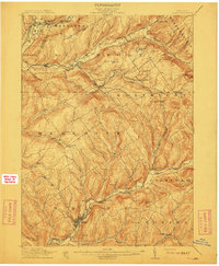
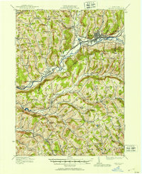
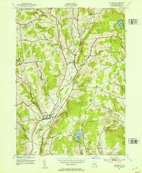
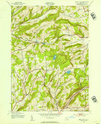
 1910 Hartwick1953 Print · USGSOtsego County's rural landscape is meticulously detailed during the early twentieth century, showing a world of hillside farms and valley hamlets. Genealogists and historians can trace old homesteads and transport routes like the O & W RR near Mt Vision and South Hartwick.
 - 1910 Map of New Berlin, 1963 Print
 1910 New Berlin1963 Print · USGSThe Unadilla and Chenango river valleys are seen here in the early twentieth century as established rail corridors and farming hubs. Researchers can trace the N Y O & W R R line through Holmesville or locate family sites like Kings Settlement and the Dimmick Hollow School.
 - 1911 Map of Delhi
 1911 Delhi1911 Print · USGSDelaware County during the first decade of the twentieth century shows a landscape of rail-driven river towns and high hill farms. You can trace the historic routes of the Ulster and Delaware RR and locate local landmarks like the Elk Creek Church and Wakaqua Falls.5 unique versions available
 - 1912 Map of New Berlin
 1912 New Berlin1912 Print · USGSChenango County's river valleys and dairy uplands are meticulously captured in this pre-war survey of the New Berlin area. Genealogists can locate family-named landmarks and institutions like Columbus Hill Church, Kings Settlement, and the Dimmick Hollow School.4 unique versions available
 - 1912 Map of Hartwick
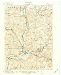
 1912 Hartwick1912 Print · USGSOtsego County's rural heartland is captured here at the height of its rail-and-river economy in the years before the Great War. Genealogists can trace family homesteads near Burlington Flats, New Lisbon, and the tracks of the O & H Electric line.4 unique versions available
 - 1915 Map of Oneonta
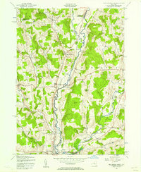
 1915 Oneonta1915 Print · USGSOtsego and Delaware counties thrived at this moment in the early twentieth century as a busy corridor for the Ulster and Delaware railroad. Genealogists and local historians can trace family-named schoolhouses and the agricultural economy at Arctic Creamery or the rural Franklin Depot.
 - 1915 Map of Unadilla, 1961 Print
 1915 Unadilla1961 Print · USGSThe river valleys of Chenango and Delaware counties are shown here during the height of the steam rail era. Researchers can trace the New York Ontario and Western lines through Sidney and Bainbridge, or locate the Friends Meeting House and dozens of rural schoolhouses.
 - 1918 Map of Unadilla
 1918 Unadilla1918 Print · USGSThe Susquehanna and Unadilla river valleys come alive during the years of World War I, showing a landscape of bustling rail junctions and riverside villages. Genealogists can trace family names at Lathams Corners or locate the Friends Meeting House and Sodom School.6 unique versions available
 - 1918 Map of Oneonta
 1918 Oneonta1918 Print · USGSOneonta and the Susquehanna valley are captured here at a peak of rail-driven commerce during the early twentieth century. Genealogists and historians can locate scores of numbered country schools and rural landmarks like the Arctic Creamery, Wells Bridge, and Franklin Depot.3 unique versions available
 - 1943 Map of Schuyler Lake, 1953 Print
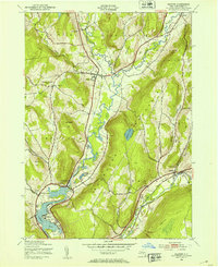
 1943 Schuyler Lake1953 Print · USGSOtsego County in the early 1940s is captured here, showing the transition from lakeside resorts to upland dairy country. Researchers can trace historic district schools like Ryder Sch and find family plots in Exeter Cem or Herkimer Cem.3 unique versions available
 - 1943 Map of Mt Vision, 1953 Print
 1943 Mt Vision1953 Print · USGSThe Otego Creek valley comes to life in the early 1940s, showing a landscape of small dairy-era settlements and hillside school districts. Family historians can locate specific landmarks like Maple Grove Cemetery, School No 5, and the rural community of Mt. Vision.5 unique versions available
 - 1943 Map of Milford, 1953 Print
 1943 Milford1953 Print · USGSMid-century Otsego County shows a landscape where the Susquehanna River and the Delaware and Hudson railroad shaped village life. Trace ancestral sites at Waters Cem or explore the rural hubs of Milford and Maryland.4 unique versions available
 - 1943 Map of Sidney, 1953 Print
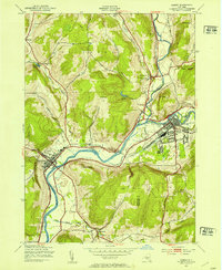 1943 Sidney1953 Print · USGSThe Susquehanna and Unadilla rivers meet during the mid-forties, carving a landscape defined by industrial rail lines and valley settlements. Genealogists can trace family roots through Greenlawn Cem, the village of Bainbridge, and the junction at Sidney.3 unique versions available
 - 1943 Map of Jordanville, 1954 Print
 1943 Jordanville1954 Print · USGSHerkimer County's agricultural uplands and spiritual centers are frozen in time during the early 1940s. Genealogists can trace local roots through several family burial grounds like Heath Cem or locate the historic Holy Trinity Monastery near Jordanville.2 unique versions available
 - 1943 Map of South Valley, 1954 Print
 1943 South Valley1954 Print · USGSOtsego County's rural townships are captured here in the 1940s, showing a landscape of small hamlets and highland farms. Genealogists can trace family roots through several schools and cemeteries, from School No 9 to Maple View Cem and Gothicville.4 unique versions available
 - 1943 Map of New Berlin North, 1957 Print
 1943 New Berlin North1957 Print · USGSChenango and Otsego counties meet along the river in the 1940s, showing a landscape of interconnected valley farms and upland hamlets. Genealogists can trace family sites like Lloyd Cem and Perkinsons Cem or follow the Unadilla Valley River rail line.4 unique versions available
Showing maps 1-25 of 95
Top cities of Otsego County
- Oneonta historical maps
- Oneonta historical maps
- Unadilla historical maps
- Otsego historical maps
- Milford historical maps
- Otego historical maps
See more
Frequently asked questions
- What are the different types of historical maps available for Otsego County?
- What is the oldest map of Otsego County?
- Where can I purchase historical maps of Otsego County for my home or office?
- Where can I download high-res historical maps of Otsego County?
- Are there historical topographic maps available for Otsego County?
- Is there historical aerial imagery available for Otsego County?
- Where are historical maps of Otsego County sourced from?