1960s Maps of Putnam County, New York
Explore 6 historic maps of Putnam County from the 1960s. These maps offer a rare glimpse into what life looked like during the 1960s — showing old roads, neighborhoods, homes, and landmarks that have changed or disappeared over time.
Whether you're researching your family's past, planning a metal detecting trip, or studying how Putnam County's landscape evolved across the 1960s, these high-resolution maps are a powerful tool for exploring the history of this region.
- Focus on a specific era: All maps on this page are from the 1960s, giving you a focused view of this time period.
- See what’s changed: Compare century-old streets, trails, and buildings to today's modern landscape using overlays and satellite layers.
- Research with precision: Use these maps for genealogy, historical research, land use analysis, or educational projects.
- View, download, or print: Maps are fully viewable online in high resolution, and can be downloaded or printed for your own records.
Start exploring Putnam County's history through authentic maps from the 1960s. This is your window into the past.
Putnam County, NY maps
(6)- 1960 Map of Poughquag, 1961 Print
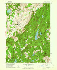 1960 Poughquag1961 Print · USGSDutchess and Putnam counties are captured in the early 1960s, showing a landscape defined by institutional landmarks and summer retreats. Genealogists and hikers can trace the Appalachian Trail past Whaley Lake or locate family plots at Beekman Cem.4 unique versions available
 - 1960 Map of Lake Carmel, 1962 Print
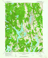 1960 Lake Carmel1962 Print · USGSPutnam County in the early sixties reveals a landscape of expanding residential tracts and massive water works. Genealogists can trace family roots through Raymond Hill Cem, the Towner Sch, or the small settlement of Farmers Mills.4 unique versions available
 - 1960 Map of Croton Falls, 1963 Print
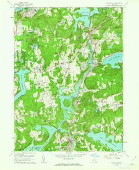 1960 Croton Falls1963 Print · USGSNorthern Westchester and Putnam County appear in the early sixties as a network of vital reservoirs and rail-stop towns. Genealogists and historians can trace institutional sites like Lincoln Hall and family burial grounds like Ivandell Cem and Warren Cem.4 unique versions available
 - 1961 Map of Hartford
 1961 Hartford1961 Print · USGSSouthern New England and the Hudson Valley are shown here in the mid-fifties, capturing a landscape of booming coastal cities and interior hill towns. Researchers can trace the legacy of the New York New Haven and Hartford rail corridor and find strategic sites like Camp Shanks and Fort Michie.
 - 1962 Map of Hartford, 1971 Print
 1962 Hartford1971 Print · USGSSouthern New England and the Hudson Valley are shown in the early sixties, as suburban growth reached into the foothills. Trace the path of the New York New Haven & Hartford RR and find landmarks like Camp Nathan Hale and Gillette Castle State Park.3 unique versions available
 - 1965 Map of Hartford
 1965 Hartford1965 Print · USGSSouthern New England and the Hudson Valley are shown here during the mid-sixties expansion of the Interstate era. Trace the path of the New York New Haven & Hartford RR or locate historic landmarks like West Point Military Reservation and the Merritt Parkway.2 unique versions available
End of results
Showing maps 1-6 of 6
Top cities of Putnam County
- Carmel historical maps
- Southeast historical maps
- Kent historical maps
- Putnam Valley historical maps
- Patterson historical maps
- Philipstown historical maps
Frequently asked questions
- What are the different types of historical maps available for Putnam County?
- What is the oldest map of Putnam County?
- Where can I purchase historical maps of Putnam County for my home or office?
- Where can I download high-res historical maps of Putnam County?
- Are there historical topographic maps available for Putnam County?
- Is there historical aerial imagery available for Putnam County?
- Where are historical maps of Putnam County sourced from?