1900s (20th Century) Maps of DeKalb Junction, De Kalb
Explore 13 historic maps of DeKalb Junction from the 1900s (20th Century). These maps offer a rare glimpse into what life looked like during the 1900s — showing old roads, neighborhoods, homes, and landmarks that have changed or disappeared over time.
Whether you're researching your family's past, planning a metal detecting trip, or studying how DeKalb Junction's landscape evolved across the 1900s, these high-resolution maps are a powerful tool for exploring the history of this region.
- Focus on a specific era: All maps on this page are from the 1900s, giving you a focused view of this time period.
- See what’s changed: Compare century-old streets, trails, and buildings to today's modern landscape using overlays and satellite layers.
- Research with precision: Use these maps for genealogy, historical research, land use analysis, or educational projects.
- View, download, or print: Maps are fully viewable online in high resolution, and can be downloaded or printed for your own records.
Start exploring DeKalb Junction's history through authentic maps from the 1900s. This is your window into the past.
DeKalb Junction, De Kalb maps
(13)- 1904 Map of Ogdensburg, 1957 Print
 1904 Ogdensburg1957 Print · USGSEarly 20th-century St. Lawrence County is defined here by the busy rail and river crossroads of Ogdensburg and its agricultural surroundings. Researchers can locate long-lost rural landmarks like Kings Corners Kokomo PO, the Bell Schoolhouse, and the sprawling St Lawrence State Hospital.
 - 1905 Map of Ogdensburg
 1905 Ogdensburg1905 Print · USGSOgdensburg and the St. Lawrence River frontier are captured here in the era of steam rail and rural post offices. Local researchers can trace old family names at Northrup Cors, locate the Fish Creek Church, or follow the river to Heuvelton and the Lost Village.4 unique versions available
 - 1915 Map of Gouverneur
 1915 Gouverneur1915 Print · USGSSt. Lawrence County comes to life in this early twentieth-century survey of the Oswegatchie River and its surrounding rail-fed towns. Researchers can trace the legacy of rural education and industry through sites like the Fullerville Ironworks, Scotch Settlement, and Ore Bed School.4 unique versions available
 - 1937 Map of Gouverneur
 1937 Gouverneur1937 Print · USGSSt. Lawrence County in the early twentieth century shows a landscape defined by the winding Oswegatchie River and a dense network of local school districts. Genealogists can locate family-named landmarks like Hailes Hopyard or rural hubs such as Fullerville Ironworks and Staplin Corners.
 - 1943 Map of Rensselaer Falls
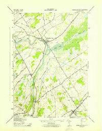 1943 Rensselaer Falls1943 Print · USGSSt. Lawrence County in the early 1940s is shown here as a landscape of rural school districts and river-bound settlements. You can trace family homesteads near Kendrew Corners or follow the New York Central rail lines into DeKalb Junction.
 - 1948 Map of Ogdensburg, 1973 Print
 1948 Ogdensburg1973 Print · USGSThe international border along the St Lawrence River comes to life in the late 1940s, showing the vital rail and water connections between New York and Ontario. Researchers can trace the grounds of St Lawrence University, the massive Camp Drum military reservation, and the historic Rideau River and Canal.2 unique versions available
 - 1951 Map of Ogdensburg
 1951 Ogdensburg1951 Print · USGSThe St. Lawrence frontier and the North Country are captured here during the post-war era, from the river ports to the high Adirondacks. Genealogists and historians can trace the rail-and-river economy through Ogdensburg, the Rutland rail lines, and Potsdam.
 - 1953 Map of Ogdensburg
 1953 Ogdensburg1953 Print · USGSThe North Country and St. Lawrence Valley are shown here in the early fifties, just as the region’s rail-and-river economy remained in full swing. Genealogists and historians can trace family-named corners and rural hubs along the Rutland railroad or locate heritage sites near Ogdensburg, Potsdam, and the St Regis Indian Reservation.
 - 1956 Map of Bigelow, 1958 Print
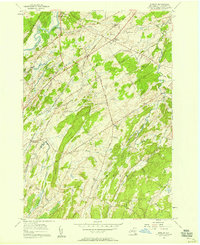 1956 Bigelow1958 Print · USGSMid-century St. Lawrence County is captured here as a landscape of small hamlets and dairy-country roads connected by the New York Central Railroad. Genealogists and local historians can trace family locations near East De Kalb, the Acres Sch, or the West Hermon Cem.2 unique versions available
 - 1961 Map of Ogdensburg
 1961 Ogdensburg1961 Print · USGSThe St. Lawrence valley and the Adirondack high country meet in this early sixties survey during a peak era for rail and river commerce. Genealogists and historians can trace the paths of the New York Central railroad through remote settlements like Wanakena, Conifer, and Piercefield.
 - 1963 Map of Rensselaer Falls, 1965 Print
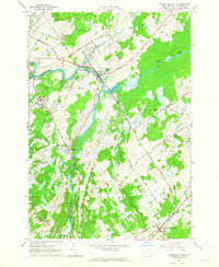 1963 Rensselaer Falls1965 Print · USGSSt. Lawrence County in the early sixties is anchored by the river-and-rail corridor connecting Rensselaer Falls and De Kalb Junction. Genealogists can locate family landmarks like Walruth Cem, Kendrew Cem, and the historic settlement at Coopers Falls.
 - 1985 Map of Gouverneur
 1985 Gouverneur1985 Print · USGSSt. Lawrence and Jefferson Counties are shown in the mid-eighties as a landscape of river-driven industry and expanding military grounds. Genealogists and historians can trace rail lines through Carthage, find local landmarks like Noble Hospital, and locate the boundaries of the Fort Drum Military Reservation.2 unique versions available
 - 1985 Map of Ogdensburg, 1986 Print
 1985 Ogdensburg1986 Print · USGSThe St. Lawrence River valley and the northern New York borderlands are shown here in the mid-1980s, during a period of established institutional and collegiate growth. Researchers can trace the paths of CONRAIL through Potsdam or locate local landmarks like Mater Dei College and Rensselaer Falls.2 unique versions available
End of results
Showing maps 1-13 of 13
Top cities near DeKalb Junction
- Potsdam historical maps
- Canton historical maps
- Ogdensburg historical maps
- Canton historical maps
- Gouverneur historical maps
- Lisbon historical maps
See more
Top neighborhoods of DeKalb Junction
Frequently asked questions
- What are the different types of historical maps available for DeKalb Junction?
- What is the oldest map of DeKalb Junction?
- Where can I purchase historical maps of DeKalb Junction for my home or office?
- Where can I download high-res historical maps of DeKalb Junction?
- Are there historical topographic maps available for DeKalb Junction?
- Is there historical aerial imagery available for DeKalb Junction?
- Where are historical maps of DeKalb Junction sourced from?