1960s Maps of Macomb, New York
Explore 7 historic maps of Macomb from the 1960s. These maps offer a rare glimpse into what life looked like during the 1960s — showing old roads, neighborhoods, homes, and landmarks that have changed or disappeared over time.
Whether you're researching your family's past, planning a metal detecting trip, or studying how Macomb's landscape evolved across the 1960s, these high-resolution maps are a powerful tool for exploring the history of this region.
- Focus on a specific era: All maps on this page are from the 1960s, giving you a focused view of this time period.
- See what’s changed: Compare century-old streets, trails, and buildings to today's modern landscape using overlays and satellite layers.
- Research with precision: Use these maps for genealogy, historical research, land use analysis, or educational projects.
- View, download, or print: Maps are fully viewable online in high resolution, and can be downloaded or printed for your own records.
Start exploring Macomb's history through authentic maps from the 1960s. This is your window into the past.
Macomb, NY maps
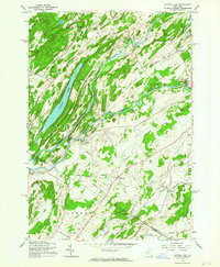
(7)- 1961 Map of Ogdensburg
 1961 Ogdensburg1961 Print · USGSThe St. Lawrence valley and the Adirondack high country meet in this early sixties survey during a peak era for rail and river commerce. Genealogists and historians can trace the paths of the New York Central railroad through remote settlements like Wanakena, Conifer, and Piercefield.
 - 1961 Map of Natural Dam, 1964 Print
 1961 Natural Dam1964 Print · USGSSt. Lawrence County in the early 1960s is defined by the winding Oswegatchie River and its riverside hamlets. Genealogists and local historians can trace family-named roads and remote settlements like Wegatchie, Little Bow, and the rail-stop at Spragueville.3 unique versions available
 - 1961 Map of Muskellunge Lake, 1964 Print
 1961 Muskellunge Lake1964 Print · USGSThe Jefferson County lake country appears in great detail in the early sixties, showing the intricate relationship between the Indian River and its surrounding glaciated terrain. Trace local history through the crossroad settlements of Oxbow, Rogers, and Chapel Corners.2 unique versions available
 - 1961 Map of Hammond, 1964 Print
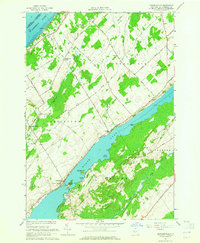
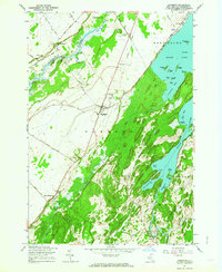 1961 Hammond1964 Print · USGSSt. Lawrence County in the early sixties reveals a landscape of lakeside hamlets and quiet river valleys. Genealogists and historians can trace family plots at Fineview Cem, explore the shores of Black Lake, or locate the crossroads at Oakvale.2 unique versions available
 - 1961 Map of Pope Mills, 1964 Print
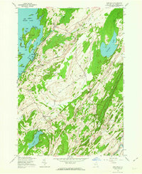 1961 Pope Mills1964 Print · USGSSt. Lawrence County in the early 1960s was a landscape of quiet crossroads and winding lakeside roads before modern expansion. Genealogists can trace family roots through sites like Brasie Corners, Woodworth Cem, and Stark School Corner.3 unique versions available
 - 1963 Map of Heuvelton, 1964 Print
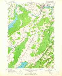 1963 Heuvelton1964 Print · USGSHeuvelton and the surrounding St. Lawrence County countryside are shown here in the early sixties, a landscape of river bends and rural crossroads. Researchers can locate family burial sites like Hill Crest Cem and trace the old New York Central rail line through Lost Village.2 unique versions available
 - 1963 Map of Edwardsville, 1965 Print
 1963 Edwardsville1965 Print · USGSThe rural lakefronts and inland farms of St. Lawrence County are captured here in the early sixties. Researchers can trace family-named roads and remote burial grounds like Davies Cem, or locate historic gathering spots such as the Scotch Bush Grange.2 unique versions available
End of results
Showing maps 1-7 of 7
Top cities near Macomb
- Canton historical maps
- Gouverneur historical maps
- Lisbon historical maps
- Oswegatchie historical maps
- Alexandria historical maps
- Gouverneur historical maps
See more
Top neighborhoods of Macomb
Frequently asked questions
- What are the different types of historical maps available for Macomb?
- What is the oldest map of Macomb?
- Where can I purchase historical maps of Macomb for my home or office?
- Where can I download high-res historical maps of Macomb?
- Are there historical topographic maps available for Macomb?
- Is there historical aerial imagery available for Macomb?
- Where are historical maps of Macomb sourced from?