1940s Maps of Oswegatchie, New York
Explore 7 historic maps of Oswegatchie from the 1940s. These maps offer a rare glimpse into what life looked like during the 1940s — showing old roads, neighborhoods, homes, and landmarks that have changed or disappeared over time.
Whether you're researching your family's past, planning a metal detecting trip, or studying how Oswegatchie's landscape evolved across the 1940s, these high-resolution maps are a powerful tool for exploring the history of this region.
- Focus on a specific era: All maps on this page are from the 1940s, giving you a focused view of this time period.
- See what’s changed: Compare century-old streets, trails, and buildings to today's modern landscape using overlays and satellite layers.
- Research with precision: Use these maps for genealogy, historical research, land use analysis, or educational projects.
- View, download, or print: Maps are fully viewable online in high resolution, and can be downloaded or printed for your own records.
Start exploring Oswegatchie's history through authentic maps from the 1940s. This is your window into the past.
Oswegatchie, NY maps
(7)- 1943 Map of Ogdensburg East
 1943 Ogdensburg East1943 Print · USGSThe St. Lawrence riverfront hums with activity during the early 1940s as Ogdensburg serves as a critical junction for rail and river transit. Genealogists can trace family homesteads near Northrup Corners or locate ancestors at Notre Dame Cem and dozens of rural school sites like School No 29.
 - 1943 Map of Rensselaer Falls
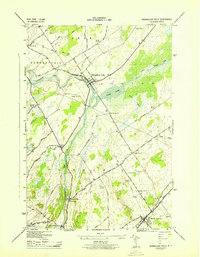 1943 Rensselaer Falls1943 Print · USGSSt. Lawrence County in the early 1940s is shown here as a landscape of rural school districts and river-bound settlements. You can trace family homesteads near Kendrew Corners or follow the New York Central rail lines into DeKalb Junction.
 - 1943 Map of Lisbon
 1943 Lisbon1943 Print · USGSLisbon and the surrounding St. Lawrence County farm country are captured here during the early 1940s. Genealogists can trace family connections through a dozen local schools and landmarks like White Ch, Flackville Cem, and the Rutland rail line.
 - 1943 Map of Edwardsville
 1943 Edwardsville1943 Print · USGSSt. Lawrence County townships are captured here in the early 1940s, showing a landscape of lakeside settlements and rural school districts. Genealogists can locate family landmarks like Davies Cem, Stone Church, and numerous schoolhouses from Morristown Center to Galilee.
 - 1943 Map of Ogdensburg West
 1943 Ogdensburg West1943 Print · USGSThe international border at the St. Lawrence River is captured here during the 1940s, showing the vital rail and ferry links between Ogdensburg and Prescott. Researchers can locate rural landmarks like the Pythian Home and numerous district schools, or trace old family routes along Lost Village Rd.
 - 1943 Map of Heuvelton
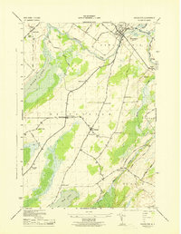 1943 Heuvelton1943 Print · USGSMid-century St. Lawrence County comes alive in this survey, showcasing the rural heart of New York near the Canadian border. Genealogists and local historians can locate the numbered district schools and settlements like Lost Village, Heuvelton, and Kokomo Corners.
 - 1948 Map of Ogdensburg, 1973 Print
 1948 Ogdensburg1973 Print · USGSThe international border along the St Lawrence River comes to life in the late 1940s, showing the vital rail and water connections between New York and Ontario. Researchers can trace the grounds of St Lawrence University, the massive Camp Drum military reservation, and the historic Rideau River and Canal.2 unique versions available
End of results
Showing maps 1-7 of 7
Top cities near Oswegatchie
- Canton historical maps
- Ogdensburg historical maps
- Gouverneur historical maps
- Lisbon historical maps
- De Kalb historical maps
- Waddington historical maps
See more
Top neighborhoods of Oswegatchie
- Galilee historical maps
- Lost Village historical maps
- Cedars Nursing Home historical maps
- Heuvelton historical maps
Frequently asked questions
- What are the different types of historical maps available for Oswegatchie?
- What is the oldest map of Oswegatchie?
- Where can I purchase historical maps of Oswegatchie for my home or office?
- Where can I download high-res historical maps of Oswegatchie?
- Are there historical topographic maps available for Oswegatchie?
- Is there historical aerial imagery available for Oswegatchie?
- Where are historical maps of Oswegatchie sourced from?