1960s Maps of Piercefield, New York
Explore 3 historic maps of Piercefield from the 1960s. These maps offer a rare glimpse into what life looked like during the 1960s — showing old roads, neighborhoods, homes, and landmarks that have changed or disappeared over time.
Whether you're researching your family's past, planning a metal detecting trip, or studying how Piercefield's landscape evolved across the 1960s, these high-resolution maps are a powerful tool for exploring the history of this region.
- Focus on a specific era: All maps on this page are from the 1960s, giving you a focused view of this time period.
- See what’s changed: Compare century-old streets, trails, and buildings to today's modern landscape using overlays and satellite layers.
- Research with precision: Use these maps for genealogy, historical research, land use analysis, or educational projects.
- View, download, or print: Maps are fully viewable online in high resolution, and can be downloaded or printed for your own records.
Start exploring Piercefield's history through authentic maps from the 1960s. This is your window into the past.
Piercefield, NY maps
(3)- 1961 Map of Ogdensburg
 1961 Ogdensburg1961 Print · USGSThe St. Lawrence valley and the Adirondack high country meet in this early sixties survey during a peak era for rail and river commerce. Genealogists and historians can trace the paths of the New York Central railroad through remote settlements like Wanakena, Conifer, and Piercefield.
 - 1968 Map of Mount Matumbla, 1970 Print
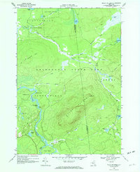 1968 Mount Matumbla1970 Print · USGSThe Adirondack wilderness at the Franklin and St. Lawrence county line is captured here in the late sixties. Researchers can trace the Old Railroad Grade past the settlement of Kildare or navigate the series of Raquette River features like Hedgehog Rapids.2 unique versions available
 - 1968 Map of Childwold, 1971 Print
 1968 Childwold1971 Print · USGSThe Raquette River wilderness in the late sixties reveals a network of remote hamlets and scout camps. Trace the developments at Childwold, identify family burial sites at the Cem near Sevey Corners, and locate the Lookout Tower on Moosehead Mtn.
End of results
Showing maps 1-3 of 3
Top cities near Piercefield
- Harrietstown historical maps
- Tupper Lake historical maps
- Tupper Lake historical maps
- Webb historical maps
- Colton historical maps
- Hopkinton historical maps
See more
Top neighborhoods of Piercefield
- Mount Arab historical maps
- Childwold historical maps
- Gale historical maps
- Conifer historical maps
- Horseshoe historical maps
Frequently asked questions
- What are the different types of historical maps available for Piercefield?
- What is the oldest map of Piercefield?
- Where can I purchase historical maps of Piercefield for my home or office?
- Where can I download high-res historical maps of Piercefield?
- Are there historical topographic maps available for Piercefield?
- Is there historical aerial imagery available for Piercefield?
- Where are historical maps of Piercefield sourced from?