1970s Maps of Saratoga County, New York
Explore 4 historic maps of Saratoga County from the 1970s. These maps offer a rare glimpse into what life looked like during the 1970s — showing old roads, neighborhoods, homes, and landmarks that have changed or disappeared over time.
Whether you're researching your family's past, planning a metal detecting trip, or studying how Saratoga County's landscape evolved across the 1970s, these high-resolution maps are a powerful tool for exploring the history of this region.
- Focus on a specific era: All maps on this page are from the 1970s, giving you a focused view of this time period.
- See what’s changed: Compare century-old streets, trails, and buildings to today's modern landscape using overlays and satellite layers.
- Research with precision: Use these maps for genealogy, historical research, land use analysis, or educational projects.
- View, download, or print: Maps are fully viewable online in high resolution, and can be downloaded or printed for your own records.
Start exploring Saratoga County's history through authentic maps from the 1970s. This is your window into the past.
Saratoga County, NY maps
(4)- 1970 Map of Northville, 1972 Print
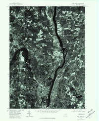
 1970 Northville1972 Print · USGSFulton County’s lakeside communities are captured here in the early seventies, showcasing the developed shoreline of the Great Sacandaga Lake. Genealogists can locate family landmarks such as Gifford Valley Cem, Sweets Crossing, and the historic settlement of Fish House.2 unique versions available
 - 1970 Map of Edinburg, 1972 Print
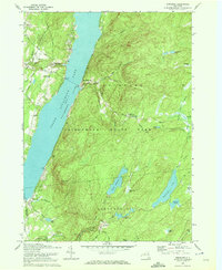 1970 Edinburg1972 Print · USGSSaratoga County life in the early seventies centers on the shores of Great Sacandaga Lake and the southern Adirondacks. Researchers can locate old family landmarks like Partridge Cem, Consolidated School No 1, and the Plateau Landing Field.2 unique versions available
 - 1970 Map of Galway, 1972 Print
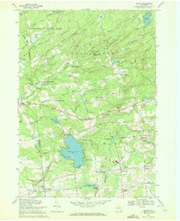 1970 Galway1972 Print · USGSSaratoga County's southern Adirondack foothills were a landscape of established hamlets and family crossroads during the early seventies. Trace local lineages and old property lines through namesake locations like Whiteside Corners, Hooseville, and the Zion Hill Cemetery.
 - 1978 Map of Troy North, 1982 Print
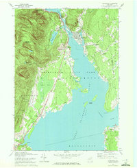
 1978 Troy North1982 Print · USGSThe confluence of the Hudson and Mohawk rivers is captured during the late seventies, showing the industrial and residential core of the Capital Region. Researchers can trace the exact 1978 footprints of Waterford, Cohoes, and Halemoon alongside the Hudson River.
End of results
Showing maps 1-4 of 4
Top cities of Saratoga County
- Clifton Park historical maps
- Saratoga Springs historical maps
- Halfmoon historical maps
- Milton historical maps
- Wilton historical maps
- Malta historical maps
See more
Frequently asked questions
- What are the different types of historical maps available for Saratoga County?
- What is the oldest map of Saratoga County?
- Where can I purchase historical maps of Saratoga County for my home or office?
- Where can I download high-res historical maps of Saratoga County?
- Are there historical topographic maps available for Saratoga County?
- Is there historical aerial imagery available for Saratoga County?
- Where are historical maps of Saratoga County sourced from?