2020s Maps of Saratoga County, New York
Explore 29 historic maps of Saratoga County from the 2020s. These maps offer a rare glimpse into what life looked like during the 2020s — showing old roads, neighborhoods, homes, and landmarks that have changed or disappeared over time.
Whether you're researching your family's past, planning a metal detecting trip, or studying how Saratoga County's landscape evolved across the 2020s, these high-resolution maps are a powerful tool for exploring the history of this region.
- Focus on a specific era: All maps on this page are from the 2020s, giving you a focused view of this time period.
- See what’s changed: Compare century-old streets, trails, and buildings to today's modern landscape using overlays and satellite layers.
- Research with precision: Use these maps for genealogy, historical research, land use analysis, or educational projects.
- View, download, or print: Maps are fully viewable online in high resolution, and can be downloaded or printed for your own records.
Start exploring Saratoga County's history through authentic maps from the 2020s. This is your window into the past.
Saratoga County, NY maps
(29)- 2023 Map of Schaghticoke, 2023 Print
 2023 Schaghticoke2023 Print · USGSThe Hoosic River valley and the tri-county borders of Rensselaer, Washington, and Saratoga are captured in this modern survey. Researchers can trace the Old Champlain Canal or locate family plots at Saint Johns Cem and Brownell Cem.
 - 2023 Map of Burnt Hills, 2023 Print
 2023 Burnt Hills2023 Print · USGSSaratoga and Schenectady counties appear here in the early 2020s, showcasing a landscape of historical hamlets and modern residential growth. Genealogists can trace family landmarks at Jeremiah Smith Cemetery and Calvary Episcopal Church, or explore crossroads like Harmony Corners.
 - 2023 Map of Troy North, 2023 Print
 2023 Troy North2023 Print · USGSThe confluence of the Hudson and Mohawk rivers comes into sharp focus in this modern survey of the Saratoga and Rensselaer county border. Researchers can trace historic burial sites like Oakwood Cem and Middletown Cem alongside the remnants of the Old Champlain Canal.
 - 2023 Map of Gansevoort, 2023 Print
 2023 Gansevoort2023 Print · USGSSaratoga County's modern landscape is captured here in the early 2020s, showing the intersection of longstanding hamlets and newer infrastructure. Genealogists can locate several historic burial grounds like Gurn Springs Cem and Emersons Corners Cem near Gurn Spring.
 - 2023 Map of Fort Miller, 2023 Print
 2023 Fort Miller2023 Print · USGSUpper Hudson River settlements and islands are captured in this contemporary look at the Washington and Saratoga County border. Researchers can trace family plots at Thompson Cem and Bacon Hill Cem or explore the riverfronts of Fort Miller and Northumberland.
 - 2023 Map of Hudson Falls, 2023 Print
 2023 Hudson Falls2023 Print · USGSThe industrial corridor of Hudson Falls and Fort Edward is captured here alongside the historic Old Champlain Canal. Genealogists and historians can trace family plots at Union Cem and Saint Pauls Cem or locate the Washington County Courthouse.
 - 2023 Map of Griffin, 2023 Print
 2023 Griffin2023 Print · USGSThe Adirondack wilderness of the 2020s remains a landscape of deep forests and high peaks centered on the Griffin and Bakertown areas. Explore the network of trails and waterways leading to Auger Falls, Wilcox Lake, and the remote marshlands of Masher Vly.
 - 2023 Map of Corinth, 2023 Print
 2023 Corinth2023 Print · USGSUpper Saratoga County at the edge of the Adirondacks is captured here in modern detail, from the riverfront of Corinth to the heights of the Palmertown Range. Genealogists can trace family heritage through numerous rural burial sites like Davis-Bedell Young Cem and Clothier Cem.
 - 2023 Map of Middle Grove, 2023 Print
 2023 Middle Grove2023 Print · USGSSaratoga County's rural communities and historic hamlets are detailed in this recent survey. Genealogists can locate family burial sites like Grenell Road Cem and Ashley Cem while tracing the waters of Glowegee Creek.
 - 2023 Map of Saratoga Springs, 2023 Print
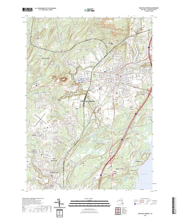 2023 Saratoga Springs2023 Print · USGSSaratoga Springs and the neighboring village of Ballston Spa appear here in detail during the early 2020s. Researchers can locate numerous local landmarks including Skidmore College, the storied estate of Yaddo, and various historic burial grounds like Greenridge Cem and Malta Ridge Cem.
 - 2023 Map of Mechanicville, 2023 Print
 2023 Mechanicville2023 Print · USGSSouthern Saratoga County's riverfront heritage is on full display in this modern survey of the Hudson Valley corridor. Researchers can trace family history through local landmarks like Yellow Meeting House Cem, the Old Champlain Canal, and Stillwater.
 - 2023 Map of Schenectady, 2023 Print
 2023 Schenectady2023 Print · USGSThe Mohawk River valley in the early twenty-first century shows a dense network of neighborhoods, from Schenectady to Niskayuna. Trace local heritage at Union College or burial sites like Saint Josephs Cem.
 - 2023 Map of Niskayuna, 2023 Print
 2023 Niskayuna2023 Print · USGSThe Mohawk River valley serves as a focal point in this contemporary survey of the Saratoga and Albany county borderlands. Family researchers can locate numerous burial sites and crossroads such as Vischer Ferry Cem and Groom Corners.
 - 2023 Map of Round Lake, 2023 Print
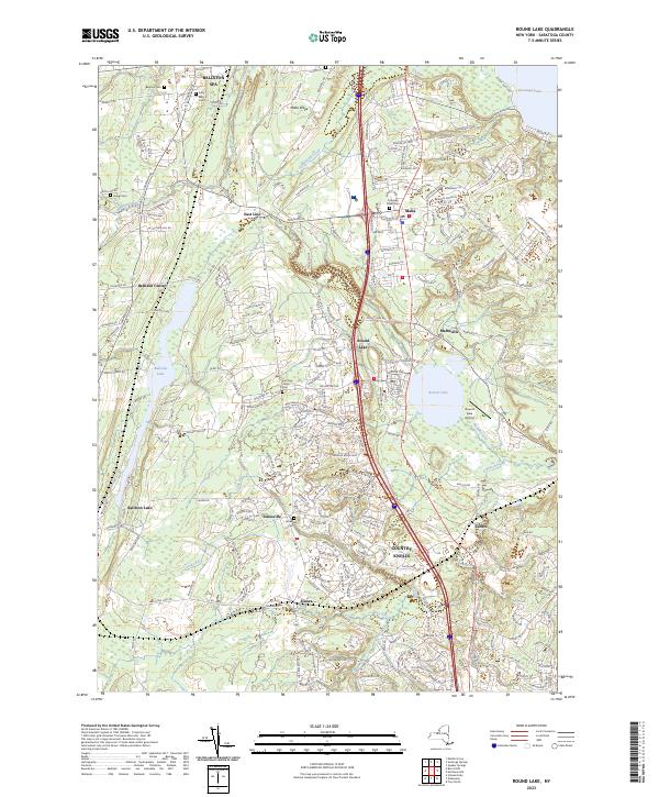 2023 Round Lake2023 Print · USGSSaratoga County's growing residential corridors meet historic village centers in this contemporary record of the region's evolving landscape. Researchers can locate several burial sites including Ballston Cem and Jonesville Cem, or trace the banks of Round Lake and Anthony Kill.
 - 2023 Map of Porter Corners, 2023 Print
 2023 Porter Corners2023 Print · USGSSaratoga County's southern Adirondack foothills appear in sharp relief during the early 2020s, showing a landscape defined by ridges and complex wetlands. Genealogists and hikers can trace family burial grounds like Day Cem and Hutchings Cem or navigate the summits of Spruce Mountain and the Kayaderosseras Range.
 - 2023 Map of Quaker Springs, 2023 Print
 2023 Quaker Springs2023 Print · USGSSaratoga County is shown here in the 2020s, where the expansion of Saratoga Springs meets the rural heritage of Quaker Springs. Genealogists and historians can trace family sites at Bryan Scidmore Cem or explore the boundaries of Saratoga National Historical Park.
 - 2023 Map of Stony Creek, 2023 Print
 2023 Stony Creek2023 Print · USGSStony Creek and the surrounding Adirondack highlands are captured in this recent survey. Genealogists and hikers can trace the paths around Hadley Mountain, locate the PO at Stony Creek, and follow the bend of the Hudson River.
 - 2023 Map of Glens Falls, 2023 Print
 2023 Glens Falls2023 Print · USGSThe Hudson River corridor and the growing suburbs of Warren and Saratoga counties are captured in this recent survey. Researchers can trace local heritage through Glens Falls Cem, SUNY Adirondack Community College, and the family-named Austin Cem.
 - 2023 Map of Warrensburg, 2023 Print
 2023 Warrensburg2023 Print · USGSWarrensburg and the surrounding Adirondack foothills are shown here at the confluence of two major rivers. Trace local genealogy at Pendell Cem or Warrensburg Cem, and explore the backcountry trails near Viele Pond and Taylor Mountain.
 - 2023 Map of Schuylerville, 2023 Print
 2023 Schuylerville2023 Print · USGSThe Saratoga and Washington County borderlands appear in this modern survey of the upper Hudson valley. Trace Revolutionary War sites near Saratoga National Historical Park and find local landmarks like Starks Knob and Powers Briggs Ferry.
 - 2023 Map of Conklingville, 2023 Print
 2023 Conklingville2023 Print · USGSSaratoga County's southern Adirondack foothills are captured here in the contemporary era, centered on the expansive Great Sacandaga Lake. Researchers can locate family landmarks like the Conklingville Cem and trace the shoreline settlements of Conklingville and Overlook.
 - 2023 Map of Lake Luzerne, 2023 Print
 2023 Lake Luzerne2023 Print · USGSWarren County and Saratoga County meet at the river bend during this modern survey of the Adirondack foothills. Genealogists can locate family sites near Old Methodist Cemetery or trace the early settlement footprints of Danielstown and Beartown.
 - 2023 Map of Northville, 2023 Print
 2023 Northville2023 Print · USGSThe northern shores of the Great Sacandaga Lake come into focus in the early twenty-first century as the Sacandaga River enters the reservoir. Genealogists and hikers can trace the beginnings of the Northville-Placid Trl or locate family plots at Prospect Hill Cem and Christie Cem.
 - 2023 Map of Ohmer Mountain, 2023 Print
 2023 Ohmer Mountain2023 Print · USGSSaratoga County's southern Adirondack foothills are shown here as they appeared in the early 2020s, centered on the high peaks and the shores of Great Sacandaga Lake. Genealogists and hikers can trace local routes to Edinburg Cem or the settlements at West Day and Day Center.
 - 2023 Map of Galway, 2023 Print
 2023 Galway2023 Print · USGSSaratoga and Fulton counties are shown in this recent survey of a landscape shaped by early mill hamlets and family settlements. Researchers can locate numerous burial sites like Galway Village Cem and trace old industry at Hagedorns Mills and Parkis Mills.
Showing maps 1-25 of 29
Top cities of Saratoga County
- Clifton Park historical maps
- Saratoga Springs historical maps
- Halfmoon historical maps
- Milton historical maps
- Wilton historical maps
- Malta historical maps
See more
Frequently asked questions
- What are the different types of historical maps available for Saratoga County?
- What is the oldest map of Saratoga County?
- Where can I purchase historical maps of Saratoga County for my home or office?
- Where can I download high-res historical maps of Saratoga County?
- Are there historical topographic maps available for Saratoga County?
- Is there historical aerial imagery available for Saratoga County?
- Where are historical maps of Saratoga County sourced from?