1900-1909 Maps of Schuyler County, New York
Explore 6 historic maps of Schuyler County from 1900-1909. These maps offer a rare glimpse into what life looked like during the 1900s — showing old roads, neighborhoods, homes, and landmarks that have changed or disappeared over time.
Whether you're researching your family's past, planning a metal detecting trip, or studying how Schuyler County's landscape evolved across the 1900s, these high-resolution maps are a powerful tool for exploring the history of this region.
- Focus on a specific era: All maps on this page are from the 1900s, giving you a focused view of this time period.
- See what’s changed: Compare century-old streets, trails, and buildings to today's modern landscape using overlays and satellite layers.
- Research with precision: Use these maps for genealogy, historical research, land use analysis, or educational projects.
- View, download, or print: Maps are fully viewable online in high resolution, and can be downloaded or printed for your own records.
Start exploring Schuyler County's history through authentic maps from the 1900s. This is your window into the past.
Schuyler County, NY maps
(6)- 1901 Map of Watkins
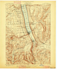 1901 Watkins1901 Print · USGSSchuyler County at the turn of the century centered on the bustling rail-and-canal nexus of the southern Finger Lakes. Genealogists and historians can trace the exact 1901 locations of Watkins, Montour Falls, and rural post offices like Barnes P. O.10 unique versions available
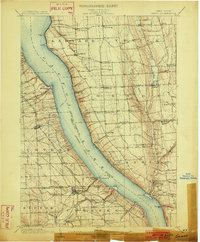
 - 1902 Map of Waverly
 1902 Waverly1902 Print · USGSThe Chemung River valley and the Pennsylvania borderlands come alive in this turn-of-the-century survey of Tioga and Chemung counties. Genealogists and rail historians can trace defunct stations and crossroads like Van Etten Junction, Owens Mills, and the village of Wellsburg.7 unique versions available
 - 1902 Map of Genoa
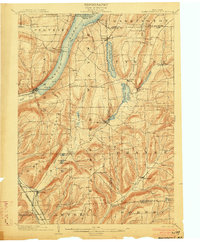
 1902 Genoa1902 Print · USGSThe Finger Lakes region thrived on water and rail transport at the turn of the century, centered on the transit hub of Cayuga Lake. Genealogists and historians can trace the early Steamboat Route and find historic sites like Wells College and Taughannic Falls.8 unique versions available
 - 1902 Map of Ovid
 1902 Ovid1902 Print · USGSThe Finger Lakes region at the turn of the century shows a landscape tied together by steamboats and competing rail lines. Genealogists and historians can trace the industrial footprints of Cascade Mills or follow the path of the Lehigh Valley R. R. through villages like Ovid and Lodi.9 unique versions available
 - 1903 Map of Hammondsport
 1903 Hammondsport1903 Print · USGSThe Finger Lakes region at the dawn of the twentieth century is defined here by the busy docks of Hammondsport and the deep waters of Keuka Lake. Researchers can trace the early Steamboat Route and a dense network of upland hamlets like Catawba and Wayne Four Corners.8 unique versions available
 - 1905 Map of Watkins Glen
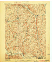
 1905 Watkins Glen1905 Print · USGSThe Finger Lakes and Southern Tier regions are captured at the start of the century, showing a landscape defined by deep glens and heavy rail. Genealogists and historians can trace the paths of the Northern Central RR through Watkins or locate family sites near Burdett and Horseheads.4 unique versions available
End of results
Showing maps 1-6 of 6
Top cities of Schuyler County
- Hector historical maps
- Dix historical maps
- Montour historical maps
- Reading historical maps
- Catharine historical maps
- Tyrone historical maps
See more
Frequently asked questions
- What are the different types of historical maps available for Schuyler County?
- What is the oldest map of Schuyler County?
- Where can I purchase historical maps of Schuyler County for my home or office?
- Where can I download high-res historical maps of Schuyler County?
- Are there historical topographic maps available for Schuyler County?
- Is there historical aerial imagery available for Schuyler County?
- Where are historical maps of Schuyler County sourced from?