2020s Maps of Schuyler County, New York
Explore 14 historic maps of Schuyler County from the 2020s. These maps offer a rare glimpse into what life looked like during the 2020s — showing old roads, neighborhoods, homes, and landmarks that have changed or disappeared over time.
Whether you're researching your family's past, planning a metal detecting trip, or studying how Schuyler County's landscape evolved across the 2020s, these high-resolution maps are a powerful tool for exploring the history of this region.
- Focus on a specific era: All maps on this page are from the 2020s, giving you a focused view of this time period.
- See what’s changed: Compare century-old streets, trails, and buildings to today's modern landscape using overlays and satellite layers.
- Research with precision: Use these maps for genealogy, historical research, land use analysis, or educational projects.
- View, download, or print: Maps are fully viewable online in high resolution, and can be downloaded or printed for your own records.
Start exploring Schuyler County's history through authentic maps from the 2020s. This is your window into the past.
Schuyler County, NY maps
(14)- 2023 Map of Montour Falls, 2023 Print
 2023 Montour Falls2023 Print · USGSThe Schuyler and Chemung county borderlands come alive in this modern survey of the Finger Lakes region. Researchers can trace ancestral roots at Cook Cem and Saint John Cem or follow the historic rail corridor of the Norfolk Southern through Millport.
 - 2023 Map of Lodi, 2023 Print
 2023 Lodi2023 Print · USGSThe upland ridges between Seneca and Cayuga Lakes are captured here in the 2020s, showing a landscape where agriculture meets federal forest land. Genealogists and local historians can trace burial sites like Seneca Union Cem and Townsendville Cem or locate the dramatic Silver Thread Falls.
 - 2023 Map of Beaver Dams, 2023 Print
 2023 Beaver Dams2023 Print · USGSSchuyler and Chemung counties are documented in this late-era survey, showing the agricultural hills and racing culture south of Seneca Lake. Researchers can locate many small burial grounds like Beaver Dams Cem or the sprawling Watkins Glen Int'l Race Track.
 - 2023 Map of Erin, 2023 Print
 2023 Erin2023 Print · USGSThe rural valleys and ridges of Chemung County appear in this modern survey, highlighting the enduring footprints of early New York settlements. Genealogists can locate several historic burial grounds including Old Baptist Cem, Van Duzer Cem, and Scotchtown Cem.
 - 2023 Map of Burdett, 2023 Print
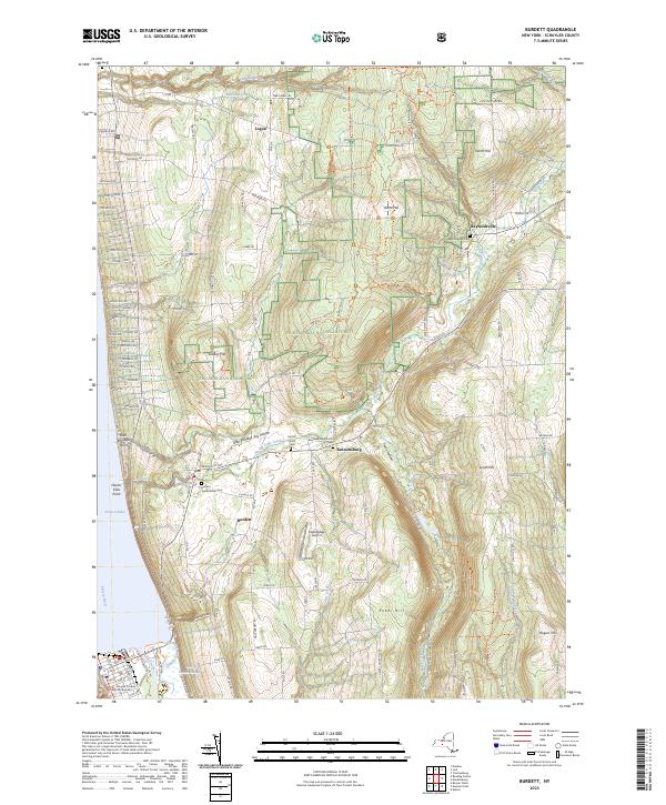 2023 Burdett2023 Print · USGSThe eastern shore of Seneca Lake and the Finger Lakes National Forest are shown in this contemporary study of Schuyler County. Genealogists and local historians can trace family plots at Burdett Presbyterian Cem or locate the historic Schuyler County Courthouse.
 - 2023 Map of Mecklenburg, 2023 Print
 2023 Mecklenburg2023 Print · USGSThe rural landscapes of Tompkins and Schuyler Counties come alive in this survey of the high plateaus and creek valleys. Genealogists and local historians can trace family roots through the Quaker Cem, McIntyre Settlement Cem, and the hamlet of Mecklenburg.
 - 2023 Map of Van Etten, 2023 Print
 2023 Van Etten2023 Print · USGSThe Southern Tier highlands come into focus during the early twenty-first century, centered on the rail-and-creek junction at Van Etten. Genealogists can trace family landmarks and rural homesteads through Swartwood Cem, Jenkins Cem, and the high reaches of Nobles Hill.
 - 2023 Map of West Danby, 2023 Print
 2023 West Danby2023 Print · USGSThe hills of Tompkins and Chemung Counties are captured here in the 2020s, showing a landscape defined by deep hollows and historic rural settlements. Genealogists can locate family burial sites at People's Baptist Cem and Valley View Cem or trace the Norfolk Southern rail line through West Danby.
 - 2023 Map of Alpine, 2023 Print
 2023 Alpine2023 Print · USGSSchuyler County's high country and deep ravines are charted here in the early 2020s, showing the landscape surrounding the southern tip of Cayuta Lake. Researchers can locate old family burial grounds like Connecticut Hill Cem and trace the winding paths of Pony Hollow Creek and Hooker Creek.
 - 2023 Map of Reading Center, 2023 Print
 2023 Reading Center2023 Print · USGSSchuyler County's western shore of Seneca Lake is documented here in the early twenty-first century, showing the transition from lakefront points to upland farms. Genealogists can locate family sites at Old Reading Cem or Rock Stream Cem and trace old roads through Reading Center.
 - 2023 Map of Trumansburg, 2023 Print
 2023 Trumansburg2023 Print · USGSThe western shores of Cayuga Lake meet the wooded uplands of the Finger Lakes in this modern survey. Genealogists can locate several historic burial grounds, including Old Covert Cem and Saint James Cem, alongside old hamlets like Podunk.
 - 2023 Map of Wayne, 2023 Print
 2023 Wayne2023 Print · USGSThe Finger Lakes region is shown in contemporary detail here, where the borders of three counties meet amidst a landscape of deep glacial lakes. Researchers can locate several rural burying grounds like McDowell Cem and old crossroads such as Weston and Altay.
 - 2023 Map of Bradford, 2023 Print
 2023 Bradford2023 Print · USGSThe upland border of Steuben and Schuyler counties is captured in the early 2020s, showing a landscape of high ridges and rural valley settlements. Genealogists can locate numerous burial sites like Old Sugar Hill Cem and Duvall Cem along the Mohawk Trl.
 - 2023 Map of Dundee, 2023 Print
 2023 Dundee2023 Print · USGSThe western shores of Seneca Lake are documented here in the early 2020s, showing the settled landscape between the Finger Lakes and the National Forest. Genealogists can locate several historic burial grounds including Dundee Presbyterian Cem and Raplee Cem near the village of Dundee.
End of results
Showing maps 1-14 of 14
Top cities of Schuyler County
- Hector historical maps
- Dix historical maps
- Montour historical maps
- Reading historical maps
- Catharine historical maps
- Tyrone historical maps
See more
Frequently asked questions
- What are the different types of historical maps available for Schuyler County?
- What is the oldest map of Schuyler County?
- Where can I purchase historical maps of Schuyler County for my home or office?
- Where can I download high-res historical maps of Schuyler County?
- Are there historical topographic maps available for Schuyler County?
- Is there historical aerial imagery available for Schuyler County?
- Where are historical maps of Schuyler County sourced from?