1900s (20th Century) Maps of Schuyler County, New York
Explore 39 historic maps of Schuyler County from the 1900s (20th Century). These maps offer a rare glimpse into what life looked like during the 1900s — showing old roads, neighborhoods, homes, and landmarks that have changed or disappeared over time.
Whether you're researching your family's past, planning a metal detecting trip, or studying how Schuyler County's landscape evolved across the 1900s, these high-resolution maps are a powerful tool for exploring the history of this region.
- Focus on a specific era: All maps on this page are from the 1900s, giving you a focused view of this time period.
- See what’s changed: Compare century-old streets, trails, and buildings to today's modern landscape using overlays and satellite layers.
- Research with precision: Use these maps for genealogy, historical research, land use analysis, or educational projects.
- View, download, or print: Maps are fully viewable online in high resolution, and can be downloaded or printed for your own records.
Start exploring Schuyler County's history through authentic maps from the 1900s. This is your window into the past.
Schuyler County, NY maps
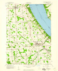
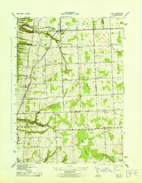
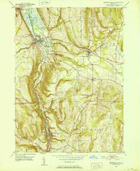
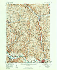
(39)- 1901 Map of Watkins
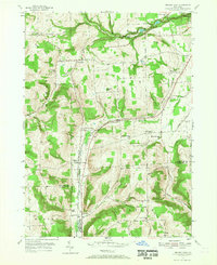
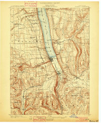 1901 Watkins1901 Print · USGSSchuyler County at the turn of the century centered on the bustling rail-and-canal nexus of the southern Finger Lakes. Genealogists and historians can trace the exact 1901 locations of Watkins, Montour Falls, and rural post offices like Barnes P. O.10 unique versions available
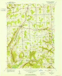
 - 1902 Map of Waverly
 1902 Waverly1902 Print · USGSThe Chemung River valley and the Pennsylvania borderlands come alive in this turn-of-the-century survey of Tioga and Chemung counties. Genealogists and rail historians can trace defunct stations and crossroads like Van Etten Junction, Owens Mills, and the village of Wellsburg.7 unique versions available
 - 1902 Map of Genoa
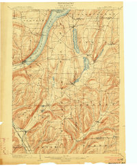
 1902 Genoa1902 Print · USGSThe Finger Lakes region thrived on water and rail transport at the turn of the century, centered on the transit hub of Cayuga Lake. Genealogists and historians can trace the early Steamboat Route and find historic sites like Wells College and Taughannic Falls.8 unique versions available
 - 1902 Map of Ovid
 1902 Ovid1902 Print · USGSThe Finger Lakes region at the turn of the century shows a landscape tied together by steamboats and competing rail lines. Genealogists and historians can trace the industrial footprints of Cascade Mills or follow the path of the Lehigh Valley R. R. through villages like Ovid and Lodi.9 unique versions available
 - 1903 Map of Hammondsport
 1903 Hammondsport1903 Print · USGSThe Finger Lakes region at the dawn of the twentieth century is defined here by the busy docks of Hammondsport and the deep waters of Keuka Lake. Researchers can trace the early Steamboat Route and a dense network of upland hamlets like Catawba and Wayne Four Corners.8 unique versions available
 - 1905 Map of Watkins Glen
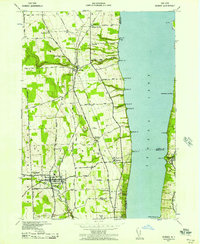
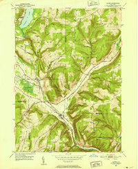
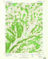
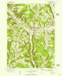
 1905 Watkins Glen1905 Print · USGSThe Finger Lakes and Southern Tier regions are captured at the start of the century, showing a landscape defined by deep glens and heavy rail. Genealogists and historians can trace the paths of the Northern Central RR through Watkins or locate family sites near Burdett and Horseheads.4 unique versions available
 - 1942 Map of Dundee, 1957 Print
 1942 Dundee1957 Print · USGSThe western shores of Seneca Lake appear in the early 1940s, revealing a landscape defined by parallel rail lines and lakeside landings. Genealogists and local historians can trace the foundations of Dundee, the grounds of Lakemont Academy, and the routes of the New York Central Railroad.3 unique versions available
 - 1942 Map of Lodi, 1960 Print
 1942 Lodi1960 Print · USGSSeneca and Schuyler counties are seen here in the early 1940s, as the rural Finger Lakes landscape was defined by family-named crossroads and lakeside rail depots. Researchers can trace ancestral farmstead locations near Cat Elbow Corner, Bumpus Corners, and the historic Round Sch.2 unique versions available
 - 1942 Map of Trumansburg, 1960 Print
 1942 Trumansburg1960 Print · USGSThe western shore of Cayuga Lake during the early years of the war shows a landscape of busy rail lines and lakeside landings. Researchers can trace family roots at Grove Cemetery or explore the rural layout of Trumansburg, Podunk, and Halseyville.
 - 1943 Map of Trumansburg
 1943 Trumansburg1943 Print · USGSThe western shores of Cayuga Lake come alive in this wartime survey, showing the agricultural heartland between Seneca and Tompkins Counties. Genealogists and local historians can trace family roots through sites like St James Cem, School No 24, and the lakeside landings at Bergen Beach.
 - 1943 Map of Dundee
 1943 Dundee1943 Print · USGSThe western shores of Seneca Lake and the village of Dundee are captured here during the Second World War. Genealogists can trace family names and properties near Lakemont Academy, Hillside Cemetery, and the rail stops at Randall Crossing.
 - 1943 Map of Lodi
 1943 Lodi1943 Print · USGSSeneca County's eastern shores and upland farms are captured here during the 1940s, showing the region's transition from lakeside rails to high ridge pastures. Genealogists can locate specific rural properties near Lodi Center, East Steamburg, and the Round Schoolhouse.
 - 1950 Map of Elmira
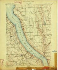
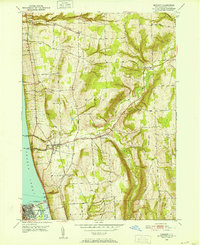
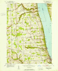
 1950 Elmira1950 Print · USGSThe Finger Lakes region thrived in the late 1940s as a hub of industry and transport. Trace family roots and vanished landmarks near Seneca Lake or explore the rail lines of the Erie RR and the sprawling Seneca Ordnance Depot.2 unique versions available
 - 1950 Map of Alpine, 1952 Print
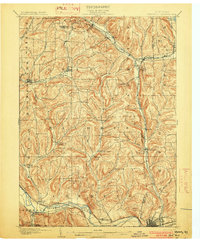
 1950 Alpine1952 Print · USGSSchuyler and Tompkins counties in the mid-century are defined here by high ridges and the winding route of the Lehigh Valley railroad. Researchers can trace the old rail junctions and find landmarks like Lawrence Memorial Chapel, Hinman Swamp, and the Fish Hatchery near Cayuta.2 unique versions available
 - 1950 Map of Burdett, 1952 Print
 1950 Burdett1952 Print · USGSThe eastern shores of Seneca Lake in the early 1950s reveal a landscape of deep glens and thriving hillside hamlets. Genealogists and local historians can trace family properties near Logan Cem, the Dolphburgh Sch, and the rail lines of the Lehigh Valley.4 unique versions available
 - 1950 Map of West Danby, 1952 Print
 1950 West Danby1952 Print · USGSMid-century Tompkins County is mapped here as a network of hill-and-valley settlements and vital rail lines. Local researchers can trace family landmarks and community nodes like Woodlawn Cem, Kellogg Corners, and the southern waters of Spencer Lake.2 unique versions available
 - 1950 Map of Montour Falls, 1952 Print
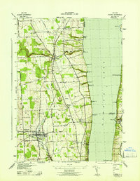
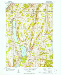
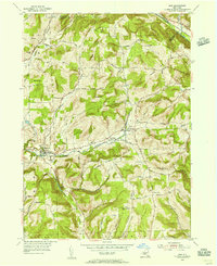
 1950 Montour Falls1952 Print · USGSThe southern tip of Seneca Lake and the glacial valleys of Schuyler County are captured here in the early postwar era. Genealogists and local historians can trace old homesteads and landmarks like St Johns Seminary, Highland Cem, and School No 9.4 unique versions available
 - 1950 Map of Mecklenburg, 1952 Print
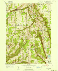
 1950 Mecklenburg1952 Print · USGSThe upland terrain of Tompkins and Schuyler Counties is documented here during the early fifties, centering on the crossroads at Mecklenburg. Researchers can trace old family sites and road networks near Bostwick Corners, the Mecklenburg Cem, and the headwaters of Taughannock Creek.3 unique versions available
 - 1950 Map of Reading Center, 1964 Print
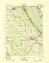
 1950 Reading Center1964 Print · USGSThe western banks of Seneca Lake come alive in the early 1950s, showing a landscape defined by deep ravines and lakeside salt works. Researchers can trace historic family landmarks from Gingerbread Corners to Reading Center, alongside old rail stops like Barnes Sta.4 unique versions available
 - 1953 Map of Wayne, 1954 Print
 1953 Wayne1954 Print · USGSThe lakeside communities of Schuyler County are pictured in the early fifties, anchored by the waters of Waneta Lake and Lamoka Lake. Researchers can locate family landmarks such as Tyrone Union Cemetery, Waneta Lake Chapel, and the curious crossing at Gingerbread Corners.2 unique versions available
 - 1953 Map of Bradford, 1955 Print
 1953 Bradford1955 Print · USGSSchuyler and Steuben Counties are captured here in the early fifties, showing a rural landscape of valley farms and upland forests. Genealogists can trace family names through numerous burial sites like Old Sugar Hill Cem and Maltby Cem, or locate local landmarks like the Star District Sch.3 unique versions available
 - 1953 Map of Beaver Dams, 1955 Print
 1953 Beaver Dams1955 Print · USGSSchuyler and Chemung counties are seen here in the early 1950s, centered on the railroad corridor and rural hamlets. Researchers can trace family history through local landmarks like Savory Cem, Catlin Center Sch, and the New York Central line at Beaver Dams.3 unique versions available
 - 1954 Map of Erin, 1956 Print
 1954 Erin1956 Print · USGSChemung County in the mid-fifties is a landscape of valley hamlets and family-named ridges like Laurel Hill. Genealogists and historians can trace local roots through several burial sites, including Old Scotchtown Cem and Hilltop Cem near Breesport.
 - 1954 Map of Van Etten, 1956 Print
 1954 Van Etten1956 Print · USGSChemung and Tioga Counties are seen here in the mid-1950s, centered on the vital rail junction at Van Etten. Genealogists and local historians can trace family-named sites like Rumsey Cem, Hicks, and landmarks along the Lehigh Valley line.
 - 1954 Map of Waverly, 1961 Print
 1954 Waverly1961 Print · USGSThe Southern Tier's river valleys and rail networks are caught at a mid-century peak in this survey of Tioga and Chemung counties. Genealogists can trace family names through landmarks like Austin Hill Cem, the Double Mill Sch, and the historical Newtown Battlefield State Park.2 unique versions available
Showing maps 1-25 of 39
Top cities of Schuyler County
- Hector historical maps
- Dix historical maps
- Montour historical maps
- Reading historical maps
- Catharine historical maps
- Tyrone historical maps
See more
Frequently asked questions
- What are the different types of historical maps available for Schuyler County?
- What is the oldest map of Schuyler County?
- Where can I purchase historical maps of Schuyler County for my home or office?
- Where can I download high-res historical maps of Schuyler County?
- Are there historical topographic maps available for Schuyler County?
- Is there historical aerial imagery available for Schuyler County?
- Where are historical maps of Schuyler County sourced from?