1910s Maps of Curtis, Campbell
Explore 1 historic maps of Curtis from the 1910s. These maps offer a rare glimpse into what life looked like during the 1910s — showing old roads, neighborhoods, homes, and landmarks that have changed or disappeared over time.
Whether you're researching your family's past, planning a metal detecting trip, or studying how Curtis's landscape evolved across the 1910s, these high-resolution maps are a powerful tool for exploring the history of this region.
- Focus on a specific era: All maps on this page are from the 1910s, giving you a focused view of this time period.
- See what’s changed: Compare century-old streets, trails, and buildings to today's modern landscape using overlays and satellite layers.
- Research with precision: Use these maps for genealogy, historical research, land use analysis, or educational projects.
- View, download, or print: Maps are fully viewable online in high resolution, and can be downloaded or printed for your own records.
Start exploring Curtis's history through authentic maps from the 1910s. This is your window into the past.
Curtis, Campbell maps
(1)- 1914 Map of Corning
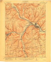 1914 Corning1914 Print · USGSSteuben County is a thriving rail and river hub during the early twentieth century, centered on the strategic confluence at Painted Post. Genealogists and local historians can locate dozens of neighborhood landmarks, including French's Mill, Lumber City School, and the remote Liberty Pole School.6 unique versions available
End of results
Showing maps 1-1 of 1
Top cities near Curtis
- Bath historical maps
- Corning historical maps
- Southport historical maps
- Erwin historical maps
- Big Flats historical maps
- Corning historical maps
See more
Frequently asked questions
- What are the different types of historical maps available for Curtis?
- What is the oldest map of Curtis?
- Where can I purchase historical maps of Curtis for my home or office?
- Where can I download high-res historical maps of Curtis?
- Are there historical topographic maps available for Curtis?
- Is there historical aerial imagery available for Curtis?
- Where are historical maps of Curtis sourced from?