1950s Maps of Troupsburg, New York
Explore 8 historic maps of Troupsburg from the 1950s. These maps offer a rare glimpse into what life looked like during the 1950s — showing old roads, neighborhoods, homes, and landmarks that have changed or disappeared over time.
Whether you're researching your family's past, planning a metal detecting trip, or studying how Troupsburg's landscape evolved across the 1950s, these high-resolution maps are a powerful tool for exploring the history of this region.
- Focus on a specific era: All maps on this page are from the 1950s, giving you a focused view of this time period.
- See what’s changed: Compare century-old streets, trails, and buildings to today's modern landscape using overlays and satellite layers.
- Research with precision: Use these maps for genealogy, historical research, land use analysis, or educational projects.
- View, download, or print: Maps are fully viewable online in high resolution, and can be downloaded or printed for your own records.
Start exploring Troupsburg's history through authentic maps from the 1950s. This is your window into the past.
Troupsburg, NY maps
(8)- 1950 Map of Elmira
 1950 Elmira1950 Print · USGSThe Finger Lakes region thrived in the late 1940s as a hub of industry and transport. Trace family roots and vanished landmarks near Seneca Lake or explore the rail lines of the Erie RR and the sprawling Seneca Ordnance Depot.2 unique versions available
 - 1953 Map of Woodhull, 1954 Print
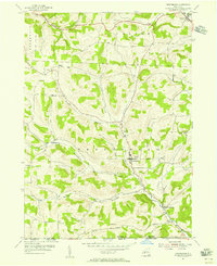
 1953 Woodhull1954 Print · USGSSteuben County farmland and ridge country are meticulously detailed in this mid-century survey just north of the Pennsylvania line. Researchers can trace rural school districts like Owlville Sch and Chenango Sch or locate the Norway Ridge Cem and the small hamlet of Five Corners.2 unique versions available
 - 1954 Map of Williamsport
 1954 Williamsport1954 Print · USGSNorth-central Pennsylvania in the mid-fifties is defined by the winding West Branch Susquehanna River and its industrial valley. Local historians can trace the massive Susquehanna Ordnance Depot and the extensive rail networks of the Pennsylvania Railroad.
 - 1954 Map of Knoxville, 1956 Print
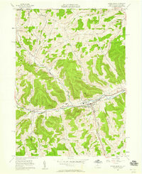
 1954 Knoxville1956 Print · USGSNorthern Tioga County in the mid-1950s is defined by its deep river valleys and the dual rail lines serving Knoxville. Genealogists can trace family sites like Woodlawn Cem and Academy Corners or locate the rural Jemison Valley Ch.3 unique versions available
 - 1954 Map of Troupsburg, 1956 Print
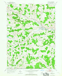
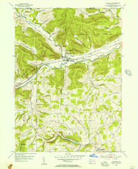
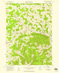
 1954 Troupsburg1956 Print · USGSThe rural borderlands of Steuben County come to life in this mid-fifties survey of the Troups Creek valley. Genealogists can locate family burial sites at Mt Vernon Cem or Card Cem and trace the old homesteads around Young Hickory and Alice.2 unique versions available
 - 1957 Map of Potter Brook, 1958 Print
 1957 Potter Brook1958 Print · USGSThe Cowanesque River valley in northern Tioga County was a busy crossroads of rail and road at the dawn of the 1960s. Family historians can trace ancestral sites through Westfield and Brookfield, identifying locations like Pleasant Cemetery and Champlin Cem.6 unique versions available
 - 1957 Map of Harrison Valley, 1958 Print
 1957 Harrison Valley1958 Print · USGSPotter County communities along the Cowanesque River are documented here in the late fifties as the regional landscape transitioned from its rail-heavy past. Local researchers can trace family landmarks like Schofield Cem, the Northern Tier Childrens Home, and the OLD RAILROAD GRADE.3 unique versions available
 - 1958 Map of Elmira
 1958 Elmira1958 Print · USGSThe New York Finger Lakes during the late fifties reveal a complex landscape of glacial geology and industrial growth. Researchers can trace historic transport corridors like the Erie Canal and Erie RR, or locate institutional landmarks like Cornell University.2 unique versions available
End of results
Showing maps 1-8 of 8
Top cities near Troupsburg
- Bath historical maps
- Alfred historical maps
- Canisteo historical maps
- Canisteo historical maps
- Woodhull historical maps
- Andover historical maps
See more
Top neighborhoods of Troupsburg
- Lila historical maps
- South Troupsburg historical maps
- Alice historical maps
- Young Hickory historical maps
Frequently asked questions
- What are the different types of historical maps available for Troupsburg?
- What is the oldest map of Troupsburg?
- Where can I purchase historical maps of Troupsburg for my home or office?
- Where can I download high-res historical maps of Troupsburg?
- Are there historical topographic maps available for Troupsburg?
- Is there historical aerial imagery available for Troupsburg?
- Where are historical maps of Troupsburg sourced from?