1950s Maps of Gardiners Island, East Hampton
Explore 2 historic maps of Gardiners Island from the 1950s. These maps offer a rare glimpse into what life looked like during the 1950s — showing old roads, neighborhoods, homes, and landmarks that have changed or disappeared over time.
Whether you're researching your family's past, planning a metal detecting trip, or studying how Gardiners Island's landscape evolved across the 1950s, these high-resolution maps are a powerful tool for exploring the history of this region.
- Focus on a specific era: All maps on this page are from the 1950s, giving you a focused view of this time period.
- See what’s changed: Compare century-old streets, trails, and buildings to today's modern landscape using overlays and satellite layers.
- Research with precision: Use these maps for genealogy, historical research, land use analysis, or educational projects.
- View, download, or print: Maps are fully viewable online in high resolution, and can be downloaded or printed for your own records.
Start exploring Gardiners Island's history through authentic maps from the 1950s. This is your window into the past.
Gardiners Island, East Hampton maps
(2)- 1956 Map of Gardiners Island East, 1957 Print
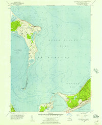 1956 Gardiners Island East1957 Print · USGSCoastal Suffolk County in the mid-fifties reveals a landscape of isolated islands and growing rail corridors. Genealogists and historians can trace the foundations of Hither Hills State Park and locate small settlements like Promised Land and Napeague.2 unique versions available
 - 1956 Map of Gardiners Island West, 1957 Print
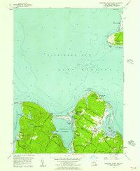 1956 Gardiners Island West1957 Print · USGSCoastal Suffolk County is captured here in the mid-fifties, showing the shoreline between the historic Gardiners Island and the mainland landings. Researchers can trace local heritage through landmarks like Our Lady of the Wayside Chapel, the Captain Kidd Monument, and the vanished era of Fireplace Lodge Girls Camp.3 unique versions available
End of results
Showing maps 1-2 of 2
Top cities near Gardiners Island
- Southampton historical maps
- Groton historical maps
- East Hampton historical maps
- New London historical maps
- Southold historical maps
- Waterford historical maps
See more
Frequently asked questions
- What are the different types of historical maps available for Gardiners Island?
- What is the oldest map of Gardiners Island?
- Where can I purchase historical maps of Gardiners Island for my home or office?
- Where can I download high-res historical maps of Gardiners Island?
- Are there historical topographic maps available for Gardiners Island?
- Is there historical aerial imagery available for Gardiners Island?
- Where are historical maps of Gardiners Island sourced from?