1970s Maps of Huntington, New York
Explore 1 historic maps of Huntington from the 1970s. These maps offer a rare glimpse into what life looked like during the 1970s — showing old roads, neighborhoods, homes, and landmarks that have changed or disappeared over time.
Whether you're researching your family's past, planning a metal detecting trip, or studying how Huntington's landscape evolved across the 1970s, these high-resolution maps are a powerful tool for exploring the history of this region.
- Focus on a specific era: All maps on this page are from the 1970s, giving you a focused view of this time period.
- See what’s changed: Compare century-old streets, trails, and buildings to today's modern landscape using overlays and satellite layers.
- Research with precision: Use these maps for genealogy, historical research, land use analysis, or educational projects.
- View, download, or print: Maps are fully viewable online in high resolution, and can be downloaded or printed for your own records.
Start exploring Huntington's history through authentic maps from the 1970s. This is your window into the past.
Huntington, NY maps
(1)- 1979 Map of Greenlawn
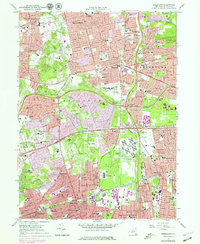 1979 Greenlawn1979 Print · USGSSuburban Long Island expands across the Huntington and Smithtown borders during a period of rapid development. Genealogists and historians can trace the footprint of dozens of local schools like Half Hollow Hills High Sch and find major landmarks including Pinelawn Cem and the State Hospital.
End of results
Showing maps 1-1 of 1
Top cities near Huntington
- Hempstead historical maps
- Brookhaven historical maps
- Islip historical maps
- Oyster Bay historical maps
- North Hempstead historical maps
- Babylon historical maps
See more
Top neighborhoods of Huntington
- Huntington Station historical maps
- Dix Hills historical maps
- East Northport historical maps
- Huntington historical maps
- Melville historical maps
- Greenlawn historical maps
See more
Frequently asked questions
- What are the different types of historical maps available for Huntington?
- What is the oldest map of Huntington?
- Where can I purchase historical maps of Huntington for my home or office?
- Where can I download high-res historical maps of Huntington?
- Are there historical topographic maps available for Huntington?
- Is there historical aerial imagery available for Huntington?
- Where are historical maps of Huntington sourced from?