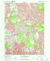
1979 Map of Greenlawn
USGS Topo · Published 1979About this map
Greenlawn and East Northport anchor the northern landscape of this Suffolk County map, showing the dense residential growth characteristic of Long Island in the late 1970s. The region is defined by a massive infrastructure of schools and public institutions, most notably the expansive State Hospital grounds near Brentwood. The terrain transitions from the suburban clusters of Little Plains and Elwood into the elevated Huntington Hills and Dix Hills, where the Northern State Parkway and Long Island Expressway carve through the landscape. Cultural and social hubs are clearly marked, from the Commack Hills Country Club to the Drive-in Theater near Commack. The southern corridor is heavily influenced by the Long Island railroad line, linking Wyandanch, Pine Aire, and Deer Park amidst a network of industrial sandpits and gravel pits.
Find a feature on this map
94 named features on this map. Tap any name to fly to it.
Don’t see what you’re looking for? This feature index may not catch every label — zoom into the map to look around manually.
Map Details
Editions of this 1979 Greenlawn Map
This is the sole edition of this map. No revisions or reprints were ever made.
Other maps of this area

1901 · Babylon
USGS Topo · 1:62,500

1901 · Northport
USGS Topo · 1:62,500

1902 · Setauket
USGS Topo · 1:62,500

1902 · Fire Island
USGS Topo · 1:62,500

1903 · Babylon
USGS Topo · 1:62,500

1903 · Northport
USGS Topo · 1:62,500

1903 · Fire Island
USGS Topo · 1:62,500

1904 · Setauket
USGS Topo · 1:62,500

1904 · Islip
USGS Topo · 1:125,000

1919 · Setauket
USGS Topo · 1:62,500