Loading...
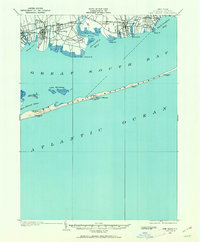
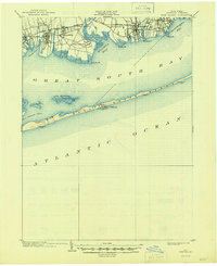
Loading map...1902 Map of Fire Island
USGS Topo · Published 1962About this map
The Montauk Division of the Long Island R. R. serves as the primary corridor for the mainland settlements of Islip, Sayville, and Bayport, establishing a transit-oriented shoreline long before the modern suburban era. This 1902 survey details the maritime-dependent geography of the South Shore, where the Connetquot River and Penataquit Cr. drain into the protected waters of Great South Bay and Nicolls Bay.
Find a feature on this map
36 named features on this map. Tap any name to fly to it.
Don’t see what you’re looking for? This feature index may not catch every label — zoom into the map to look around manually.
Map Details
Date Portrayed1902
Date Published1962
PublisherU.S. Geological Survey
Map TypeTopographic
Scale1:62,500
Physical Dimensions17 x 20.7 inches
Editions of this 1902 Fire Island Map
This is the sole edition of this map. No revisions or reprints were ever made.
Historical Maps of Brookhaven Through Time
Featured Locations
Source Details
SourceU.S. Geological Survey
CopyrightPublic Domain