
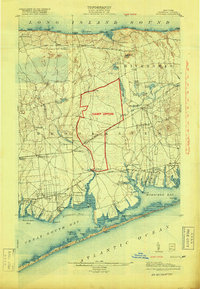
1904 Map of Moriches
USGS Topo · Published 1912About this map
The northern coast of Suffolk County is defined by a sequence of maritime landings along Long Island Sound, from Woodhull Landing to Jericho Landing. Inland, the 1903 survey reveals a landscape of scattered agricultural hamlets and evolving railway stops, such as Wardenclyffe and Wading River Sta., connected by the Long Island R. R. Port Jefferson Branch. This era represents a transition as the North Shore began to see early industrial and scientific development, most notably at Wardenclyffe.
Find a feature on this map
90 named features on this map. Tap any name to fly to it.
Don’t see what you’re looking for? This feature index may not catch every label — zoom into the map to look around manually.
Map Details
Editions of this 1904 Moriches Map
2 editions found
Other maps of this area

1891 · Bridgeport
USGS Topo · 1:62,500

1893 · Bridgeport
USGS Topo · 1:62,500

1902 · Setauket
USGS Topo · 1:62,500

1902 · Fire Island
USGS Topo · 1:62,500

1903 · Fire Island
USGS Topo · 1:62,500

1903 · Riverhead
USGS Topo · 1:62,500

1904 · Setauket
USGS Topo · 1:62,500

1904 · Islip
USGS Topo · 1:125,000

1904 · Riverhead
USGS Topo · 1:62,500

1919 · Setauket
USGS Topo · 1:62,500