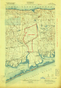
1904 Map of Moriches
USGS Topo · Published 1918About this map
Camp Upton dominates the central landscape of this Long Island survey, appearing as a significant military installation during the First World War. This 1918 reissue of the 1904 topography shows the island's South Shore and North Shore connected by the Long Island R. R. (Montauk Division) and the branch to Wading River Sta.. The coastline is dotted with numerous maritime landmarks, including Life Saving Stations such as Smith Point L.S.S. and Bellport L.S.S. guarding the thin barrier of Fire Island Beach.
Find a feature on this map
98 named features on this map. Tap any name to fly to it.
Don’t see what you’re looking for? This feature index may not catch every label — zoom into the map to look around manually.
Map Details
Editions of this 1904 Moriches Map
2 editions found
Other maps of this area

1891 · Bridgeport
USGS Topo · 1:62,500

1893 · Bridgeport
USGS Topo · 1:62,500

1902 · Setauket
USGS Topo · 1:62,500

1902 · Fire Island
USGS Topo · 1:62,500

1903 · Fire Island
USGS Topo · 1:62,500

1903 · Riverhead
USGS Topo · 1:62,500

1904 · Setauket
USGS Topo · 1:62,500

1904 · Islip
USGS Topo · 1:125,000

1904 · Riverhead
USGS Topo · 1:62,500

1904 · Moriches
USGS Topo · 1:62,500