1950s Maps of Smithtown, New York
Explore 10 historic maps of Smithtown from the 1950s. These maps offer a rare glimpse into what life looked like during the 1950s — showing old roads, neighborhoods, homes, and landmarks that have changed or disappeared over time.
Whether you're researching your family's past, planning a metal detecting trip, or studying how Smithtown's landscape evolved across the 1950s, these high-resolution maps are a powerful tool for exploring the history of this region.
- Focus on a specific era: All maps on this page are from the 1950s, giving you a focused view of this time period.
- See what’s changed: Compare century-old streets, trails, and buildings to today's modern landscape using overlays and satellite layers.
- Research with precision: Use these maps for genealogy, historical research, land use analysis, or educational projects.
- View, download, or print: Maps are fully viewable online in high resolution, and can be downloaded or printed for your own records.
Start exploring Smithtown's history through authentic maps from the 1950s. This is your window into the past.
Smithtown, NY maps
(10)- 1951 Map of Sherwood Point, 1952 Print
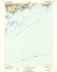 1951 Sherwood Point1952 Print · USGSThe Connecticut coast at the start of the 1950s shows a landscape of growing seaside neighborhoods and maritime heritage. Genealogists and local historians can trace family-named landmarks from Hale Court and Compo Hills to the shores of Sherwood Millpond.4 unique versions available
 - 1954 Map of New York
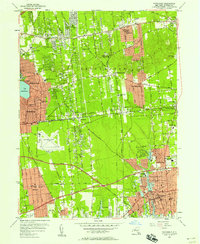
 1954 New York1954 Print · USGSLong Island and the New York metropolitan area are shown during the height of post-war suburbanization. Genealogists and historians can trace the growth of Levittown, the infrastructure of the Long Island Rail Road, and landmarks like Mitchel Afb.2 unique versions available
 - 1954 Map of Northport, 1955 Print
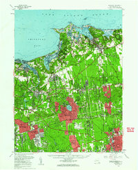
 1954 Northport1955 Print · USGSNorthport and the surrounding harbors are shown during the post-war growth of the mid-fifties. Genealogists and local historians can trace the development of East Northport, find family plots at Skidmore Cem, and locate the Central State Hosp.2 unique versions available
 - 1954 Map of Greenlawn, 1956 Print
 1954 Greenlawn1956 Print · USGSWestern Suffolk County is shown here in the mid-fifties as suburban grids begin to surround massive institutional grounds and parkways. Genealogists can trace family burial sites like Buffett Cem and Carll Cem or locate the Deer Park Airport and Pilgrim State Hospital.2 unique versions available
 - 1955 Map of Saint James, 1963 Print
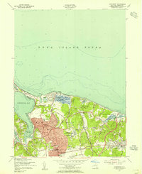
 1955 Saint James1963 Print · USGSCoastal Suffolk County shows its mid-century character as the residential corridors of Saint James and Stony Brook expand. Researchers can trace the grounds of Kings Park State Hospital, find early family sites like Wheeler Cem, or locate the Civil Air Patrol Landing Strip near the harbor.
 - 1956 Map of Central Islip, 1957 Print
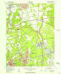
 1956 Central Islip1957 Print · USGSMid-century Suffolk County is captured here during a period of massive suburban expansion along the central Island. Researchers can trace the massive footprints of the Central Islip State Hospital, locate family plots in Calvary Cem, or follow the early routes of the Long Island Motor Parkway.2 unique versions available
 - 1956 Map of Patchogue, 1958 Print
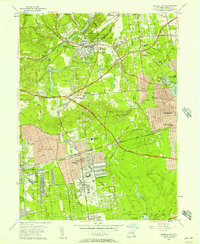
 1956 Patchogue1958 Print · USGSMid-century Suffolk County comes alive in this survey of the central Long Island corridor from the South Shore to the Ronkonkoma hills. Researchers can trace the mid-century footprint of Mac Arthur Airport or locate family history at Holy Sepulchre Cem and Medford Station.2 unique versions available
 - 1956 Map of Setauket, 1961 Print
 1956 Setauket1961 Print · USGSMid-century central Suffolk County is captured here during a period of significant suburban growth and institutional prominence. Researchers can trace the massive grounds of Central Islip State Hospital, locate the St James Cem, or explore the maritime layout of Port Jefferson.
 - 1957 Map of New York, 1975 Print
 1957 New York1975 Print · USGSLong Island and the New York metropolitan area are shown in this mid-century survey during a period of massive suburban growth and industrial expansion. Researchers can trace the Long Island RR network and locate landmarks like Fort Tilden or the Brookhaven National Laboratory.
 - 1958 Map of New York
 1958 New York1958 Print · USGSLong Island at the height of its postwar expansion reveals a landscape of rapidly growing suburbs and critical military installations. Genealogists and historians can trace the early footprints of Levittown, the terminals of Idlewild Airport, and the grounds of Brookhaven National Laboratory.3 unique versions available
End of results
Showing maps 1-10 of 10
Top cities near Smithtown
- Brookhaven historical maps
- Islip historical maps
- Oyster Bay historical maps
- Babylon historical maps
- Huntington historical maps
- Bridgeport historical maps
See more
Top neighborhoods of Smithtown
- Smithtown historical maps
- Kings Park historical maps
- Saint James historical maps
- Nesconset historical maps
- the Branch historical maps
- Nissequogue historical maps
See more
Frequently asked questions
- What are the different types of historical maps available for Smithtown?
- What is the oldest map of Smithtown?
- Where can I purchase historical maps of Smithtown for my home or office?
- Where can I download high-res historical maps of Smithtown?
- Are there historical topographic maps available for Smithtown?
- Is there historical aerial imagery available for Smithtown?
- Where are historical maps of Smithtown sourced from?