1950s Maps of Peconic, Southold
Explore 2 historic maps of Peconic from the 1950s. These maps offer a rare glimpse into what life looked like during the 1950s — showing old roads, neighborhoods, homes, and landmarks that have changed or disappeared over time.
Whether you're researching your family's past, planning a metal detecting trip, or studying how Peconic's landscape evolved across the 1950s, these high-resolution maps are a powerful tool for exploring the history of this region.
- Focus on a specific era: All maps on this page are from the 1950s, giving you a focused view of this time period.
- See what’s changed: Compare century-old streets, trails, and buildings to today's modern landscape using overlays and satellite layers.
- Research with precision: Use these maps for genealogy, historical research, land use analysis, or educational projects.
- View, download, or print: Maps are fully viewable online in high resolution, and can be downloaded or printed for your own records.
Start exploring Peconic's history through authentic maps from the 1950s. This is your window into the past.
Peconic, Southold maps
(2)- 1956 Map of Southold, 1958 Print
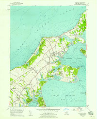 1956 Southold1958 Print · USGSThe North Fork of Long Island in the mid-fifties shows a serene landscape of coastal villages and maritime heritage before modern suburbanization. Researchers can trace family sites near Willow Hill Cem, the path of the Long Island Railroad, and local landmarks like the Drive-in Theater.3 unique versions available
 - 1956 Map of Mattituck Hills, 1958 Print
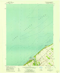 1956 Mattituck Hills1958 Print · USGSThe North Fork of Long Island comes into focus during the mid-fifties, showing the maritime landscape from Mattituck Inlet to the high ground of the Mattituck Hills. Genealogists and local historians can trace family-named routes like Reeve Road and Alvahs Road or locate early settlements at Shore Acres and Waterville.2 unique versions available
End of results
Showing maps 1-2 of 2
Top cities near Peconic
- Southampton historical maps
- Riverhead historical maps
- East Hampton historical maps
- Southold historical maps
- Guilford historical maps
- Madison historical maps
See more
Frequently asked questions
- What are the different types of historical maps available for Peconic?
- What is the oldest map of Peconic?
- Where can I purchase historical maps of Peconic for my home or office?
- Where can I download high-res historical maps of Peconic?
- Are there historical topographic maps available for Peconic?
- Is there historical aerial imagery available for Peconic?
- Where are historical maps of Peconic sourced from?