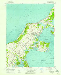
1956 Map of Southold
USGS Topo · Published 1958About this map
Horton Pt Lighthouse stands as a sentinel over the North Fork's northern shore in this mid-century survey of eastern Long Island. The landscape reveals a network of coastal hamlets, including Southold, Peconic, and Cutchogue, linked by the Long Island Railroad and the historic Main Road. The area's transition into a seasonal destination is evident through landmarks like the North Fork Country Club and the Southold Yacht Club, while traditional local institutions such as Sacred Heart Cem and Peconic Sch anchor the year-round community. The intricate shoreline is defined by numerous inlets and coves, from Goldsmith Inlet to the tidal reaches of Goose Creek. To the south, the survey captures the northern tip of the Morton National Wildlife Refuge and the waters of Little Peconic Bay, illustrating the area's maritime character and ecological importance.
Find a feature on this map
91 named features on this map. Tap any name to fly to it.
Don’t see what you’re looking for? This feature index may not catch every label — zoom into the map to look around manually.
Map Details
Editions of this 1956 Southold Map
3 editions found
Other maps of this area

1903 · Sag Harbor
USGS Topo · 1:62,500

1903 · Riverhead
USGS Topo · 1:62,500

1904 · Sag Harbor
USGS Topo · 1:62,500

1904 · Shelter Island
USGS Topo · 1:62,500

1904 · Riverhead
USGS Topo · 1:62,500

1943 · Riverhead
USGS Topo · 1:62,500

1946 · Sag Harbor
USGS Topo · 1:24,000
1947 · Orient
USGS Topo · 1:24,000

1947 · Mattituck
USGS Topo · 1:24,000

1947 · Mattituck Hills
USGS Topo · 1:24,000