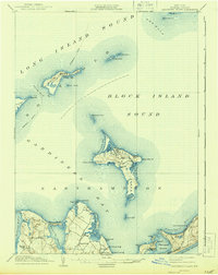
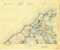
1904 Map of Shelter Island
USGS Topo · Published 1904About this map
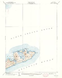
Shelter Island Sound and the surrounding Peconic Bays define this maritime landscape at the eastern end of Long Island. The map reveals a dense network of coastal settlements and summer destinations, from the established whaling port of Sag Harbor to the seasonal elegance of the Manhanset House and Shelter Island Heights. The Long Island RR serves as the primary inland artery, terminating at the active maritime hub of Greenport, while numerous Steamboat Routes crisscross the surrounding waters. A close study of the shoreline shows an economy deeply tied to the sea, marked by life-saving stations, identified here as L.S.S., and essential navigation aids like L.H. lighthouses. Local place names such as Hog Neck, Peters Neck Pt., and Mashomack Pt. reflect centuries of family landownership and geographic heritage.
Find a feature on this map
87 named features on this map. Tap any name to fly to it.
Don’t see what you’re looking for? This feature index may not catch every label — zoom into the map to look around manually.
Map Details
Editions of this 1904 Shelter Island Map
6 editions found

Historical Maps of Southampton Through Time
10 maps found