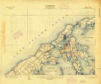
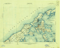
1904 Map of Shelter Island
USGS Topo · Published 1913About this map
Shelter Island and the North Fork of Long Island define this coastal landscape at the dawn of the twentieth century, illustrating a maritime economy reliant on the Long Island railroad and established steamboat routes. The map documents prominent Victorian-era landmarks such as the Manhanset House and the development of Shelter Island Heights. Along the jagged shoreline, intricate coastal features like Coecles Inlet and Pipes Cove provide safe harbor near the bustling village of Greenport. The interior of the island and the surrounding peninsulas are marked by family-named points and hills, including Browns Hills and Jennings Pt., which offer a detailed view of the regional topography before mid-century suburbanization. To the south, the village of Sag Harbor anchors the edge of Noyack Bay, while the rail line serves agricultural hubs like Cutchogue Sta. and Peconic.
Find a feature on this map
85 named features on this map. Tap any name to fly to it.
Don’t see what you’re looking for? This feature index may not catch every label — zoom into the map to look around manually.
Map Details
Editions of this 1904 Shelter Island Map
6 editions found
Other maps of this area

1903 · Sag Harbor
USGS Topo · 1:62,500

1903 · Gardiners Island
USGS Topo · 1:62,500

1903 · Riverhead
USGS Topo · 1:62,500

1904 · Sag Harbor
USGS Topo · 1:62,500

1904 · Shelter Island
USGS Topo · 1:62,500

1904 · Easthampton
USGS Topo · 1:62,500

1904 · Gardiners Island
USGS Topo · 1:62,500

1904 · Riverhead
USGS Topo · 1:62,500

1921 · Gardiners Island
USGS Topo · 1:62,500

1921 · Easthampton
USGS Topo · 1:62,500