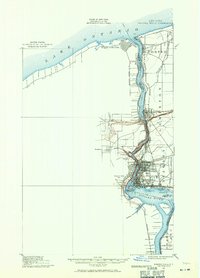
1900 Map of Niagara Falls
USGS Topo · Published 1971About this map
Fort Niagara and its lighthouse stand at the northern tip of the peninsula where the Niagara River meets Lake Ontario, anchoring a landscape defined by international borders and early industrial infrastructure. This survey captures the complex transport network around the cataract, featuring the intricate street grid of Niagara Falls and the significant rail junctions at Suspension Bridge. The map details various islands like Goat Id. and Navy Id., while highlighting the proximity of Niagara-on-the-Lake and Youngstown across the water.
Find a feature on this map
52 named features on this map. Tap any name to fly to it.
Don’t see what you’re looking for? This feature index may not catch every label — zoom into the map to look around manually.
Map Details
Editions of this 1900 Niagara Falls Map
4 editions found
Other maps of this area

1894 · Buffalo
USGS Topo · 1:62,500

1894 · Niagara Falls
USGS Topo · 1:62,500

1894 · Wilson
USGS Topo · 1:62,500

1896 · Niagara Falls
USGS Topo · 1:62,500

1897 · Tonawanda
USGS Topo · 1:62,500

1899 · Niagara
USGS Topo · 1:125,000

1900 · Wilson
USGS Topo · 1:62,500

1900 · Tonawanda
USGS Topo · 1:62,500

1900 · Niagara Falls
USGS Topo · 1:62,500

1901 · Buffalo
USGS Topo · 1:62,500