1920s Maps of Bethel, New York
Explore 3 historic maps of Bethel from the 1920s. These maps offer a rare glimpse into what life looked like during the 1920s — showing old roads, neighborhoods, homes, and landmarks that have changed or disappeared over time.
Whether you're researching your family's past, planning a metal detecting trip, or studying how Bethel's landscape evolved across the 1920s, these high-resolution maps are a powerful tool for exploring the history of this region.
- Focus on a specific era: All maps on this page are from the 1920s, giving you a focused view of this time period.
- See what’s changed: Compare century-old streets, trails, and buildings to today's modern landscape using overlays and satellite layers.
- Research with precision: Use these maps for genealogy, historical research, land use analysis, or educational projects.
- View, download, or print: Maps are fully viewable online in high resolution, and can be downloaded or printed for your own records.
Start exploring Bethel's history through authentic maps from the 1920s. This is your window into the past.
Bethel, NY maps
(3)- 1921 Map of Livingston Manor, 1952 Print
 1921 Livingston Manor1952 Print · USGSSullivan County in the early twenties is captured here as a landscape of timber processing and rail-connected mountain towns. Genealogists and historians can trace numerous rural districts like the Ireland School or find specific industrial sites such as the Acid Plant and Dye Works.2 unique versions available
 - 1922 Map of White Lake
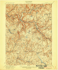
 1922 White Lake1922 Print · USGSSullivan County's lake-strewn highlands appear here in the early twenties, showing a landscape defined by small mountain hamlets and rural school districts. Genealogists can trace family names through landmarks like Stewart Cemetery, Bauer's Mill, and Mount Hope School.6 unique versions available
 - 1923 Map of Livingston Manor
 1923 Livingston Manor1923 Print · USGSSullivan County in the early twenties shows a landscape transitioning between timber industries and mountain recreation. Genealogists and historians can locate dozens of district schools like Sprague School and trace industrial sites like the Acid Plant along the Ontario and Western RR.5 unique versions available
End of results
Showing maps 1-3 of 3
Top cities near Bethel
- Thompson historical maps
- Fallsburg historical maps
- Mamakating historical maps
- Liberty historical maps
- Deerpark historical maps
- Monticello historical maps
See more
Top neighborhoods of Bethel
- Bushville historical maps
- Black Lake historical maps
- Hurd Settlement historical maps
- Odell historical maps
- Briscoe historical maps
- Smallwood historical maps
See more
Frequently asked questions
- What are the different types of historical maps available for Bethel?
- What is the oldest map of Bethel?
- Where can I purchase historical maps of Bethel for my home or office?
- Where can I download high-res historical maps of Bethel?
- Are there historical topographic maps available for Bethel?
- Is there historical aerial imagery available for Bethel?
- Where are historical maps of Bethel sourced from?